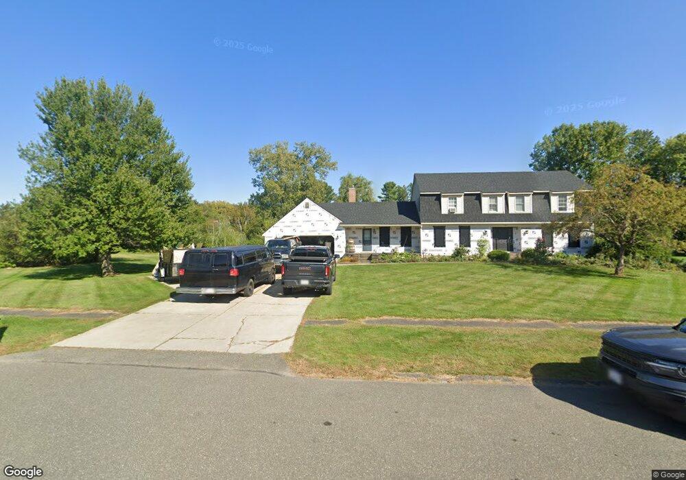
81 Stonehenge Rd Pittsfield, MA 01201
Estimated Value: $614,998 - $691,000
4
Beds
3
Baths
2,944
Sq Ft
$225/Sq Ft
Est. Value
About This Home
This home is located at 81 Stonehenge Rd, Pittsfield, MA 01201 and is currently estimated at $662,250, approximately $224 per square foot. 81 Stonehenge Rd is a home located in Berkshire County with nearby schools including Williams Elementary School, Theodore Herberg Middle School, and Sinai Academy of the Berkshires.
Ownership History
Date
Name
Owned For
Owner Type
Purchase Details
Closed on
May 1, 2009
Sold by
Fenn James D and Fenn Alice E
Bought by
Strassell Craig W and Strassell Karen A
Current Estimated Value
Home Financials for this Owner
Home Financials are based on the most recent Mortgage that was taken out on this home.
Original Mortgage
$356,250
Outstanding Balance
$225,208
Interest Rate
4.86%
Mortgage Type
Purchase Money Mortgage
Estimated Equity
$437,042
Purchase Details
Closed on
Aug 24, 2004
Sold by
Phelps David E and Phelps Madeline M
Bought by
Fenn James D and Fenn Alice E
Create a Home Valuation Report for This Property
The Home Valuation Report is an in-depth analysis detailing your home's value as well as a comparison with similar homes in the area
Home Values in the Area
Average Home Value in this Area
Purchase History
| Date | Buyer | Sale Price | Title Company |
|---|---|---|---|
| Strassell Craig W | $375,000 | -- | |
| Fenn James D | $365,000 | -- |
Source: Public Records
Mortgage History
| Date | Status | Borrower | Loan Amount |
|---|---|---|---|
| Open | Strassell Craig W | $356,250 |
Source: Public Records
Tax History Compared to Growth
Tax History
| Year | Tax Paid | Tax Assessment Tax Assessment Total Assessment is a certain percentage of the fair market value that is determined by local assessors to be the total taxable value of land and additions on the property. | Land | Improvement |
|---|---|---|---|---|
| 2025 | $9,980 | $556,300 | $81,800 | $474,500 |
| 2024 | $8,957 | $485,500 | $81,800 | $403,700 |
| 2023 | $8,312 | $453,700 | $81,800 | $371,900 |
| 2022 | $7,521 | $405,200 | $81,800 | $323,400 |
| 2021 | $7,665 | $398,200 | $81,800 | $316,400 |
| 2020 | $7,636 | $387,400 | $81,800 | $305,600 |
| 2019 | $7,183 | $369,900 | $81,800 | $288,100 |
| 2018 | $7,090 | $354,300 | $76,800 | $277,500 |
| 2017 | $6,849 | $348,900 | $81,800 | $267,100 |
| 2016 | $6,632 | $353,500 | $81,800 | $271,700 |
| 2015 | $6,384 | $353,500 | $81,800 | $271,700 |
Source: Public Records
Map
Nearby Homes
- 68 Brookside Dr
- 787 Williams St
- 59 Joan Dr
- 4 Filomena Dr
- 565 Williams St
- 932 Williams St
- 989 Williams St
- 26 Leona Dr
- 381 Williams St
- 189 Doreen St
- 106 Sampson Pkwy
- 171 Harryel St
- 171 Pine Grove Dr
- 51 Anita Dr
- 69 Gravesleigh Terrace
- 40 Sampson Pkwy
- 100 Elaine Dr
- 104 Washington Mountain Rd
- 82 Quirico Dr
- 36 Joseph Dr
- 26 Brookside Dr
- 28 Brookside Dr
- 91 Stonehenge Rd
- 71 Stonehenge Rd
- 24 Brookside Dr
- 30 Brookside Dr
- 80 Stonehenge Rd
- 90 Stonehenge Rd
- 27 Brookside Dr
- 25 Brookside Dr
- 70 Stonehenge Rd
- 29 Brookside Dr
- 22 Brookside Dr
- 23 Brookside Dr
- 61 Stonehenge Rd
- 33 Brookside Dr
- 116 Alfred Dr
- 108 Alfred Dr
- 124 Alfred Dr
- 20 Brookside Dr