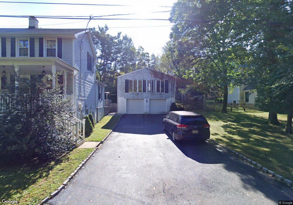
810 Canal Rd Princeton, NJ 08540
Estimated Value: $762,901 - $1,234,000
--
Bed
--
Bath
3,218
Sq Ft
$315/Sq Ft
Est. Value
About This Home
This home is located at 810 Canal Rd, Princeton, NJ 08540 and is currently estimated at $1,015,225, approximately $315 per square foot. 810 Canal Rd is a home located in Mercer County with nearby schools including Maurice Hawk Elementary School, Village Elementary School, and Thomas R. Grover Middle School.
Ownership History
Date
Name
Owned For
Owner Type
Purchase Details
Closed on
Sep 18, 2020
Sold by
Duffy James and Duffy Leslie
Bought by
Gat Jonathan and Murphy Kathleen
Current Estimated Value
Purchase Details
Closed on
May 18, 2000
Purchase Details
Closed on
Jul 10, 1992
Sold by
Henderson Robert and Henderson Kerri
Bought by
Wrenn Abigail R
Purchase Details
Closed on
Aug 24, 1989
Sold by
Pearse-Drance Pearse-Drance R and Pearse-Drance Voskrencia,T J
Bought by
Henderson Robert D and Henderson Ratcliffe,K
Create a Home Valuation Report for This Property
The Home Valuation Report is an in-depth analysis detailing your home's value as well as a comparison with similar homes in the area
Home Values in the Area
Average Home Value in this Area
Purchase History
| Date | Buyer | Sale Price | Title Company |
|---|---|---|---|
| Gat Jonathan | $780,000 | Old Republic Title | |
| -- | $220,000 | -- | |
| Wrenn Abigail R | $224,000 | -- | |
| Henderson Robert D | $235,000 | -- |
Source: Public Records
Tax History Compared to Growth
Tax History
| Year | Tax Paid | Tax Assessment Tax Assessment Total Assessment is a certain percentage of the fair market value that is determined by local assessors to be the total taxable value of land and additions on the property. | Land | Improvement |
|---|---|---|---|---|
| 2025 | $15,426 | $503,300 | $261,000 | $242,300 |
| 2024 | $14,782 | $503,300 | $261,000 | $242,300 |
| 2023 | $14,782 | $503,300 | $261,000 | $242,300 |
| 2022 | $14,449 | $501,700 | $261,000 | $240,700 |
| 2021 | $14,329 | $501,700 | $261,000 | $240,700 |
| 2020 | $14,068 | $501,700 | $261,000 | $240,700 |
| 2019 | $13,907 | $501,700 | $261,000 | $240,700 |
| 2018 | $13,777 | $501,700 | $261,000 | $240,700 |
| 2017 | $13,491 | $501,700 | $261,000 | $240,700 |
| 2016 | $13,200 | $501,700 | $261,000 | $240,700 |
| 2015 | $12,894 | $501,700 | $261,000 | $240,700 |
| 2014 | $12,743 | $501,700 | $261,000 | $240,700 |
Source: Public Records
Map
Nearby Homes
- 0 Basin St
- 409 Basin St
- 21 Dorset Ct
- 19 Dorset Ct
- 14 Kensington Ct
- 304 Trinity Ct Unit 11
- 306 Trinity Ct Unit 12
- 160 Springdale Rd
- 9 Cromwell Ct
- 237 Varsity Ave
- 1 Fieldwood Ct Unit 612
- 111 Biscayne Ct Unit 4
- 200 Parkside Dr
- 53 E Shrewsbury Place
- 98 Nassau St Unit 3
- 10 Corio Ct
- 8 Corio Ct
- 49 Palmer Square W Unit D
- 82 Library Place
- 87 Library Place