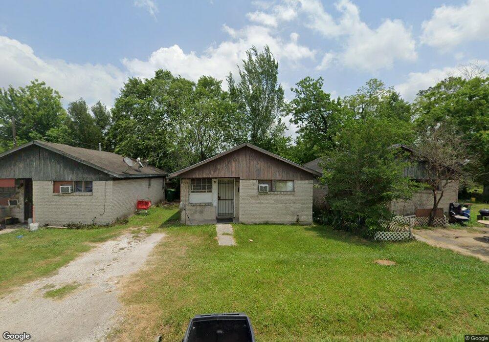
8105 Rock Rose St Houston, TX 77051
Sunnyside NeighborhoodEstimated Value: $117,000 - $253,000
--
Bed
1
Bath
686
Sq Ft
$256/Sq Ft
Est. Value
About This Home
This home is located at 8105 Rock Rose St, Houston, TX 77051 and is currently estimated at $175,365, approximately $255 per square foot. 8105 Rock Rose St is a home located in Harris County with nearby schools including Young Elementary School, Attucks Middle School, and Worthing High School.
Ownership History
Date
Name
Owned For
Owner Type
Purchase Details
Closed on
Mar 1, 2002
Sold by
Tran Thoung Tri and Winfrey Wilber
Bought by
Tran Gia
Current Estimated Value
Purchase Details
Closed on
Nov 2, 2001
Sold by
Jones Pamela Elaine
Bought by
Authorlee Joseph G
Purchase Details
Closed on
Mar 1, 2001
Sold by
Kuper Mony and Kuper Leon
Bought by
Tran Thoung Tri and Winfrey Wilber
Create a Home Valuation Report for This Property
The Home Valuation Report is an in-depth analysis detailing your home's value as well as a comparison with similar homes in the area
Home Values in the Area
Average Home Value in this Area
Purchase History
| Date | Buyer | Sale Price | Title Company |
|---|---|---|---|
| Tran Gia | -- | -- | |
| Authorlee Joseph G | -- | -- | |
| Tran Thoung Tri | -- | -- |
Source: Public Records
Tax History Compared to Growth
Tax History
| Year | Tax Paid | Tax Assessment Tax Assessment Total Assessment is a certain percentage of the fair market value that is determined by local assessors to be the total taxable value of land and additions on the property. | Land | Improvement |
|---|---|---|---|---|
| 2025 | $3,316 | $156,912 | $78,750 | $78,162 |
| 2024 | $3,316 | $158,458 | $73,500 | $84,958 |
| 2023 | $3,624 | $179,854 | $68,250 | $111,604 |
| 2022 | $3,500 | $158,959 | $52,500 | $106,459 |
| 2021 | $2,609 | $111,948 | $36,750 | $75,198 |
| 2020 | $2,318 | $95,718 | $30,188 | $65,530 |
| 2019 | $2,264 | $89,482 | $22,313 | $67,169 |
| 2018 | $1,986 | $78,487 | $15,750 | $62,737 |
| 2017 | $1,937 | $76,602 | $11,813 | $64,789 |
| 2016 | $1,937 | $76,602 | $11,813 | $64,789 |
| 2015 | $1,538 | $71,134 | $11,813 | $59,321 |
| 2014 | $1,538 | $59,815 | $11,813 | $48,002 |
Source: Public Records
Map
Nearby Homes
- 4607 Bricker St
- 4614 Redbud St
- 4548 Briscoe St
- 7905 Rock Rose St
- 4545 Bricker St
- 4608 White Rock St
- 4741 Bricker St
- 8107 Calhoun Rd
- 8201 Calhoun Rd Unit A/B
- 4555 Newberry St
- 4638 Sunflower St Unit 9
- 4718 Teton St
- 4523 Sunflower St
- 4843 Bricker St
- 4526 Edfield St
- 4515 Teton St
- 4830 Teton St
- 4624 Mayflower St Unit A/B
- 8521 Dosia St
- 8533 Amadwe St Unit A/B
- 8103 Rock Rose St
- 8109 Rock Rose St
- 4604 Briscoe St
- 4601 White Rock St
- 4601 White Rock St
- 4606 Briscoe St
- 4601 Whiterock St
- 4605 White Rock St
- 4546 Briscoe St
- 4541 White Rock St
- 4638 Briscoe St
- 8011 Rock Rose St
- 4607 White Rock St
- 4605 Briscoe St
- 4609 Briscoe St
- 4609 White Rock St
- 4611 Briscoe St
- 4611 Briscoe St Unit A
- 4611 Briscoe St Unit A , B
- 4611 Briscoe St Unit B