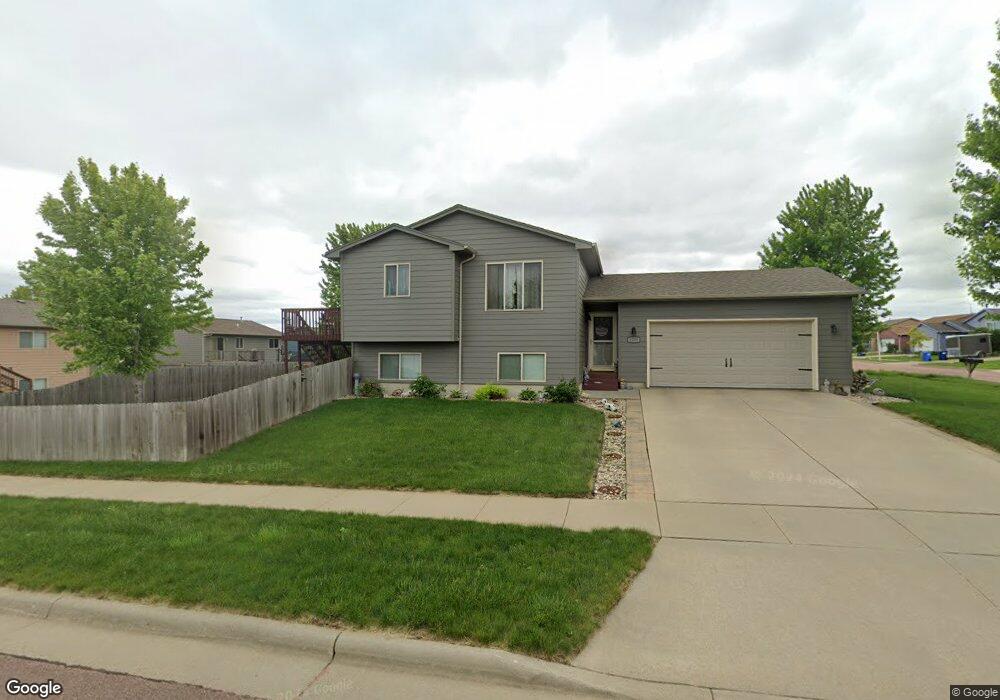
8109 W Kelsey St Sioux Falls, SD 57106
Northwest Sioux Falls NeighborhoodEstimated Value: $302,000 - $311,000
3
Beds
2
Baths
1,454
Sq Ft
$210/Sq Ft
Est. Value
About This Home
This home is located at 8109 W Kelsey St, Sioux Falls, SD 57106 and is currently estimated at $305,282, approximately $209 per square foot. 8109 W Kelsey St is a home located in Minnehaha County with nearby schools including Discovery Elementary School, Memorial Middle School, and Jefferson High School - 67.
Ownership History
Date
Name
Owned For
Owner Type
Purchase Details
Closed on
Apr 7, 2014
Sold by
Hegar A Hegar A
Bought by
Dwire Anddrew J and Dwire Kristin J
Current Estimated Value
Home Financials for this Owner
Home Financials are based on the most recent Mortgage that was taken out on this home.
Original Mortgage
$129,000
Outstanding Balance
$97,953
Interest Rate
4.31%
Mortgage Type
Stand Alone First
Estimated Equity
$207,329
Purchase Details
Closed on
Dec 14, 2009
Sold by
Douglas County State Of Nebraska
Bought by
Ismail Heger A
Create a Home Valuation Report for This Property
The Home Valuation Report is an in-depth analysis detailing your home's value as well as a comparison with similar homes in the area
Home Values in the Area
Average Home Value in this Area
Purchase History
| Date | Buyer | Sale Price | Title Company |
|---|---|---|---|
| Dwire Anddrew J | $139,000 | Dataquick Title Llc | |
| Ismail Heger A | -- | -- |
Source: Public Records
Mortgage History
| Date | Status | Borrower | Loan Amount |
|---|---|---|---|
| Open | Dwire Anddrew J | $129,000 |
Source: Public Records
Tax History Compared to Growth
Tax History
| Year | Tax Paid | Tax Assessment Tax Assessment Total Assessment is a certain percentage of the fair market value that is determined by local assessors to be the total taxable value of land and additions on the property. | Land | Improvement |
|---|---|---|---|---|
| 2024 | $3,580 | $261,400 | $29,700 | $231,700 |
| 2023 | $3,527 | $248,100 | $29,700 | $218,400 |
| 2022 | $3,320 | $219,900 | $29,700 | $190,200 |
| 2021 | $2,775 | $199,300 | $0 | $0 |
| 2020 | $2,775 | $175,400 | $0 | $0 |
| 2019 | $2,637 | $163,404 | $0 | $0 |
| 2018 | $2,430 | $160,051 | $0 | $0 |
| 2016 | $2,328 | $144,700 | $29,280 | $115,420 |
| 2015 | $2,289 | $136,719 | $27,652 | $109,067 |
| 2014 | -- | $135,628 | $27,652 | $107,976 |
Source: Public Records
Map
Nearby Homes
- 604 S Mary Gene Ave
- 813 S Clearbrook Ave
- 8709 W Rathburn St
- 8008 W Browning St
- 521 S Big Stone Ave
- 7805 W Noah Cir
- 7809 W Stoney Creek St
- 8605 W Bryggen Ct
- 1200 S Monticello Ave
- 8905 W 18th St
- 1315 S President Ct
- 1301 Hyannis Port Ln
- 7524 W Boysenberry St
- 100 N Bryggen Place
- 1501 S Wheatland Ave
- 8613 W Shoreline Place
- 8611 W Shoreline Place
- 8609 W Shoreline Place
- 102 N Bryggen Place
- 8607 W Shoreline Place
- 8109 W Kelsey St St
- 704 S Tanglewood Ave
- 701 S Wheatland Ave
- 8112 W Kelsey Cir
- 705 S Wheatland Ave
- 8112 W Kelsey St
- 8108 W Kelsey St
- 8104 W Kelsey St
- 705 S Tanglewood Ave
- 701 S Tanglewood Ave
- 709 S Wheatland Ave
- 709 S Tanglewood Ave
- 712 S Tanglewood Ave
- 8100 W Kelsey St
- 8116 W Kelsey St
- 8116 W Kelsey St St
- 713 S Wheatland Ave
- 716 S Tanglewood Ave
- 717 S Tanglewood Ave
- 717 S Wheatland Ave