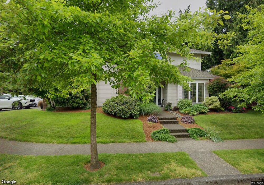
811 Nicole Ct West Linn, OR 97068
Willamette NeighborhoodEstimated Value: $831,865 - $929,000
4
Beds
3
Baths
2,540
Sq Ft
$342/Sq Ft
Est. Value
About This Home
This home is located at 811 Nicole Ct, West Linn, OR 97068 and is currently estimated at $869,466, approximately $342 per square foot. 811 Nicole Ct is a home located in Clackamas County with nearby schools including Willamette Primary School, Athey Creek Middle School, and West Linn High School.
Ownership History
Date
Name
Owned For
Owner Type
Purchase Details
Closed on
Jun 2, 2016
Sold by
Harnish Ian and Harnish Gina M
Bought by
Clarke Wade M and Clarke Bogdana A
Current Estimated Value
Home Financials for this Owner
Home Financials are based on the most recent Mortgage that was taken out on this home.
Original Mortgage
$417,000
Outstanding Balance
$331,202
Interest Rate
3.59%
Mortgage Type
New Conventional
Estimated Equity
$538,264
Purchase Details
Closed on
Jun 15, 2006
Sold by
Blessing Gale Elaine and Bergstrom Gale B
Bought by
Harnish Ian and Harnish Gina M
Home Financials for this Owner
Home Financials are based on the most recent Mortgage that was taken out on this home.
Original Mortgage
$40,000
Interest Rate
6.55%
Mortgage Type
Credit Line Revolving
Create a Home Valuation Report for This Property
The Home Valuation Report is an in-depth analysis detailing your home's value as well as a comparison with similar homes in the area
Home Values in the Area
Average Home Value in this Area
Purchase History
| Date | Buyer | Sale Price | Title Company |
|---|---|---|---|
| Clarke Wade M | $535,000 | Fidelity Natl Title Of Or | |
| Harnish Ian | $480,000 | Fidelity Natl Title Co Of Or |
Source: Public Records
Mortgage History
| Date | Status | Borrower | Loan Amount |
|---|---|---|---|
| Open | Clarke Wade M | $417,000 | |
| Previous Owner | Harnish Ian | $40,000 | |
| Previous Owner | Harnish Ian | $384,000 |
Source: Public Records
Tax History Compared to Growth
Tax History
| Year | Tax Paid | Tax Assessment Tax Assessment Total Assessment is a certain percentage of the fair market value that is determined by local assessors to be the total taxable value of land and additions on the property. | Land | Improvement |
|---|---|---|---|---|
| 2025 | $9,435 | $489,584 | -- | -- |
| 2024 | $9,082 | $475,325 | -- | -- |
| 2023 | $9,082 | $461,481 | $0 | $0 |
| 2022 | $8,572 | $448,040 | $0 | $0 |
| 2021 | $8,137 | $434,991 | $0 | $0 |
| 2020 | $8,193 | $422,322 | $0 | $0 |
| 2019 | $7,813 | $410,022 | $0 | $0 |
| 2018 | $7,402 | $398,080 | $0 | $0 |
| 2017 | $6,991 | $386,485 | $0 | $0 |
| 2016 | $6,786 | $375,228 | $0 | $0 |
| 2015 | $6,305 | $364,299 | $0 | $0 |
| 2014 | $6,013 | $353,688 | $0 | $0 |
Source: Public Records
Map
Nearby Homes
- 812 Wendy Ct
- 1075 Epperly Way
- 2250 River Heights Cir
- 1160 Blankenship Rd
- 1765 Ostman Rd
- 1101 Ryan Ct
- 1925 Hillhouse Dr
- 25540 Cheryl Dr
- 2420 Margery St
- 1733 Jamie Cir
- 1694 16th St
- 1690 16th St
- 1721 Dollar St Unit 1721
- 975 Springtree Ln
- 640 Springtree Ln
- 880 Springtree Ln Unit 880
- 800 Springtree Ln
- 2026 Virginia Ln
- 850 Springtree Ln Unit 850
- 1618 Village Park Place