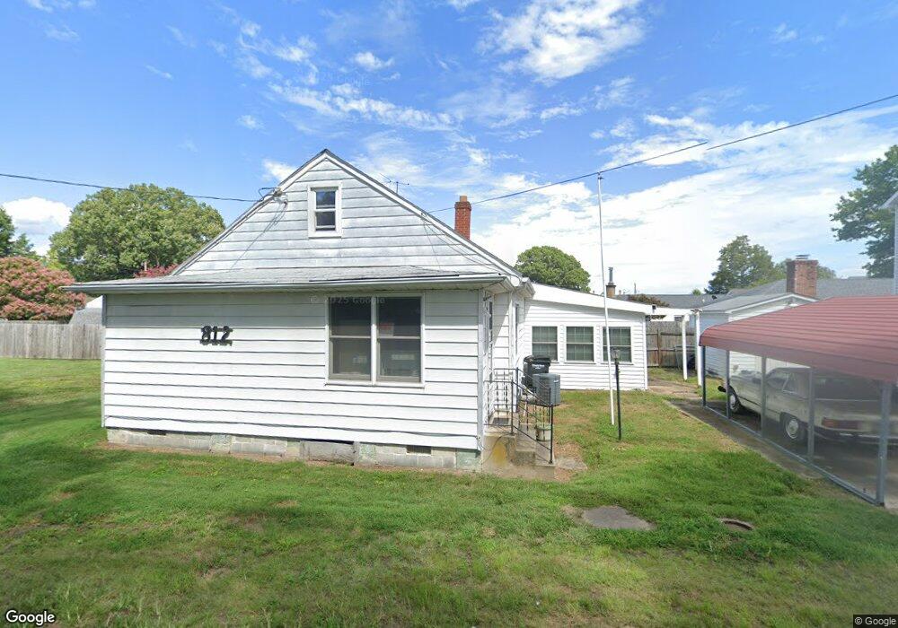
812 Bancroft Ave Colonial Beach, VA 22443
Estimated Value: $287,514 - $410,000
2
Beds
1
Bath
1,156
Sq Ft
$298/Sq Ft
Est. Value
About This Home
This home is located at 812 Bancroft Ave, Colonial Beach, VA 22443 and is currently estimated at $344,879, approximately $298 per square foot. 812 Bancroft Ave is a home located in Westmoreland County with nearby schools including Colonial Beach Elementary School and Colonial Beach High School.
Ownership History
Date
Name
Owned For
Owner Type
Purchase Details
Closed on
Aug 14, 2018
Sold by
Hudson Paul Eugene and Hudson James Carlton
Bought by
Tiches Demetrios and Caires Tamey
Current Estimated Value
Home Financials for this Owner
Home Financials are based on the most recent Mortgage that was taken out on this home.
Original Mortgage
$86,250
Outstanding Balance
$74,435
Interest Rate
4.5%
Mortgage Type
New Conventional
Estimated Equity
$270,445
Create a Home Valuation Report for This Property
The Home Valuation Report is an in-depth analysis detailing your home's value as well as a comparison with similar homes in the area
Home Values in the Area
Average Home Value in this Area
Purchase History
| Date | Buyer | Sale Price | Title Company |
|---|---|---|---|
| Tiches Demetrios | $115,000 | Lawyers Title/Westmoreland |
Source: Public Records
Mortgage History
| Date | Status | Borrower | Loan Amount |
|---|---|---|---|
| Open | Tiches Demetrios | $86,250 |
Source: Public Records
Tax History
| Year | Tax Paid | Tax Assessment Tax Assessment Total Assessment is a certain percentage of the fair market value that is determined by local assessors to be the total taxable value of land and additions on the property. | Land | Improvement |
|---|---|---|---|---|
| 2025 | $642 | $152,800 | $39,200 | $113,600 |
| 2024 | $642 | $152,800 | $39,200 | $113,600 |
| 2023 | $611 | $152,800 | $39,200 | $113,600 |
| 2022 | $611 | $152,800 | $39,200 | $113,600 |
| 2021 | $599 | $128,300 | $39,200 | $89,100 |
| 2020 | $603 | $128,300 | $39,200 | $89,100 |
| 2018 | $513 | $128,300 | $39,200 | $89,100 |
| 2017 | -- | $128,300 | $39,200 | $89,100 |
| 2016 | $500 | $128,300 | $39,200 | $89,100 |
| 2015 | -- | $122,300 | $39,200 | $83,100 |
| 2014 | -- | $0 | $0 | $0 |
| 2013 | -- | $121,600 | $39,200 | $82,400 |
Source: Public Records
Map
Nearby Homes
- 400 Wirt St
- 408 Wirt St
- 1212 Lossing Ave
- 412 Marshall Ave
- 1226 Bancroft Ave
- 26 Marshall Ave
- 19 Bancroft Ave
- LOT 6 Bancroft Ave
- 100 Taylor St Unit 505
- 100 Taylor St Unit 302
- 209 Hawthorn St
- 227 Wilder Ave
- 1252 Shore Dr
- 14 Westmoreland Dr
- 307 Monroe Point Dr
- 309 Monroe Point Dr
- Lot 66A Elkins
- 504 Monroe Point Dr
- 207 Lincoln Ave
- 704 Jackson St
Your Personal Tour Guide
Ask me questions while you tour the home.