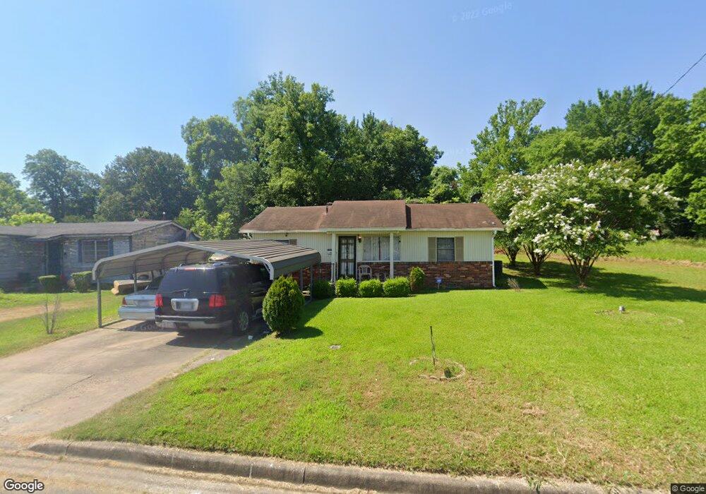
812 E 10th Ave Pine Bluff, AR 71601
Estimated Value: $54,000 - $60,000
Studio
1
Bath
1,295
Sq Ft
$44/Sq Ft
Est. Value
About This Home
This home is located at 812 E 10th Ave, Pine Bluff, AR 71601 and is currently estimated at $56,439, approximately $43 per square foot. 812 E 10th Ave is a home located in Jefferson County with nearby schools including Matthews Elementary School, Dollarway High School, and Hope Academy.
Ownership History
Date
Name
Owned For
Owner Type
Purchase Details
Closed on
Jul 19, 2017
Bought by
Mays Timothy
Current Estimated Value
Purchase Details
Closed on
Jul 12, 2017
Sold by
Smith Bessie Mae
Bought by
Mays Timothy
Purchase Details
Closed on
Aug 16, 2007
Sold by
Smith Bessie
Bought by
Smith Smith Jr Herbert Jr Herbert and Smith Jones Debra Ann
Purchase Details
Closed on
Jul 6, 2004
Bought by
Smith Herbert
Purchase Details
Closed on
Jul 20, 1976
Bought by
Smith Bessie
Create a Home Valuation Report for This Property
The Home Valuation Report is an in-depth analysis detailing your home's value as well as a comparison with similar homes in the area
Purchase History
| Date | Buyer | Sale Price | Title Company |
|---|---|---|---|
| Mays Timothy | $25,000 | -- | |
| Mays Timothy | $25,000 | None Available | |
| Smith Smith Jr Herbert Jr Herbert | -- | -- | |
| Smith Herbert | -- | -- | |
| Smith Bessie | -- | -- |
Source: Public Records
Tax History
| Year | Tax Paid | Tax Assessment Tax Assessment Total Assessment is a certain percentage of the fair market value that is determined by local assessors to be the total taxable value of land and additions on the property. | Land | Improvement |
|---|---|---|---|---|
| 2025 | $388 | $5,760 | $450 | $5,310 |
| 2024 | $388 | $5,760 | $450 | $5,310 |
| 2023 | $387 | $5,760 | $450 | $5,310 |
| 2022 | $320 | $5,220 | $200 | $5,020 |
| 2021 | $320 | $5,220 | $200 | $5,020 |
| 2020 | $320 | $5,220 | $200 | $5,020 |
| 2019 | $320 | $5,220 | $200 | $5,020 |
| 2018 | $320 | $5,220 | $200 | $5,020 |
| 2017 | $1 | $2,690 | $200 | $2,490 |
| 2016 | $0 | $2,690 | $200 | $2,490 |
| 2015 | $0 | $2,690 | $200 | $2,490 |
| 2014 | -- | $2,690 | $200 | $2,490 |
Source: Public Records
Map
Nearby Homes
- 1120 E 8th Ave
- .18 Acre E 6th Ave
- 812 S Nebraska St
- 919 S Nebraska St
- 517 E 17th Ave
- 310 W 11th Ave Unit 312
- 1200 S Walnut St Unit 1202
- 1307 S Dakota St
- 402 W Martin Place
- 1019 S Olive St
- 716 S Walnut St
- 208 Rutherford Place
- 315 W 15th Ave
- 1909 Lucia Ln
- 1509 S Walnut St
- 1603 Belmoor Dr
- 3217 E 4th Ave
- 1307 S Laurel St
- 1313 S Laurel St
- 808 W 15th Ave
- 814 E 10th Ave
- 1001 S Missouri St
- 816 E 10th Ave
- 1000 S Virginia St
- 1002 S Virginia St
- 1009 S Missouri St
- 1006 S Virginia St
- 1011 S Missouri St
- 1000 S Missouri St
- 1004 S Missouri St
- 904 E 10th Ave
- 817 E 11th Ave Unit 819
- 1001 S Virginia St
- 1003 S Virginia St
- 1005 S Virginia St
- 1014 S Missouri St
- 1015 S Virginia St Unit 1017
- 1018 S Missouri St
- 915 E 10th Ave
- E E 11th Ave
Your Personal Tour Guide
Ask me questions while you tour the home.