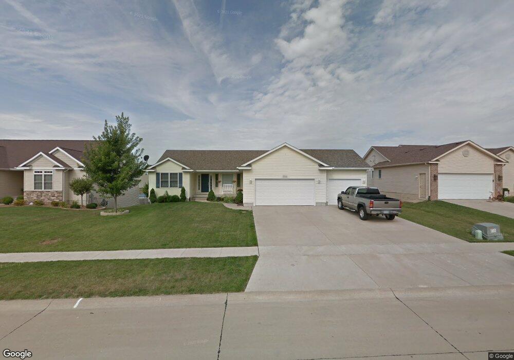
812 Sawgrass Ct Eldridge, IA 52748
Estimated Value: $420,000 - $474,000
4
Beds
3
Baths
2,505
Sq Ft
$176/Sq Ft
Est. Value
About This Home
This home is located at 812 Sawgrass Ct, Eldridge, IA 52748 and is currently estimated at $439,978, approximately $175 per square foot. 812 Sawgrass Ct is a home located in Scott County with nearby schools including Edward White Elementary School, North Scott Junior High School, and North Scott Senior High School.
Ownership History
Date
Name
Owned For
Owner Type
Purchase Details
Closed on
Jul 27, 2006
Sold by
Fitzpatrick Homes Inc
Bought by
Larson Robert D and Larson Brittney D
Current Estimated Value
Purchase Details
Closed on
Oct 31, 2005
Sold by
Townsend Farm Developers L C
Bought by
Fitzpatrick Homes Inc
Create a Home Valuation Report for This Property
The Home Valuation Report is an in-depth analysis detailing your home's value as well as a comparison with similar homes in the area
Home Values in the Area
Average Home Value in this Area
Purchase History
| Date | Buyer | Sale Price | Title Company |
|---|---|---|---|
| Larson Robert D | $48,000 | None Available | |
| Fitzpatrick Homes Inc | $46,000 | None Available |
Source: Public Records
Mortgage History
| Date | Status | Borrower | Loan Amount |
|---|---|---|---|
| Closed | Larson Robert D | $0 |
Source: Public Records
Tax History
| Year | Tax Paid | Tax Assessment Tax Assessment Total Assessment is a certain percentage of the fair market value that is determined by local assessors to be the total taxable value of land and additions on the property. | Land | Improvement |
|---|---|---|---|---|
| 2025 | $4,100 | $369,400 | $89,800 | $279,600 |
| 2024 | $3,990 | $338,500 | $78,900 | $259,600 |
| 2023 | $3,784 | $338,500 | $78,900 | $259,600 |
| 2022 | $3,666 | $272,490 | $48,450 | $224,040 |
| 2021 | $3,666 | $272,490 | $48,450 | $224,040 |
| 2020 | $3,590 | $261,400 | $48,450 | $212,950 |
| 2019 | $3,632 | $253,330 | $40,380 | $212,950 |
| 2018 | $3,704 | $253,330 | $40,380 | $212,950 |
| 2017 | $1,391 | $253,330 | $40,380 | $212,950 |
| 2016 | $3,396 | $232,150 | $0 | $0 |
| 2015 | $3,396 | $222,560 | $0 | $0 |
| 2014 | $3,304 | $222,560 | $0 | $0 |
| 2013 | $3,242 | $0 | $0 | $0 |
| 2012 | -- | $224,440 | $40,380 | $184,060 |
Source: Public Records
Map
Nearby Homes
- 116 Pinehurst Dr
- 318 W Oak St
- 101 W Sheridan Dr
- 1218 S 2nd St
- 513 S 7th St
- 1867 Redbud Cir Unit 103
- 1832 Redbud Cir
- 1867 Redbud Cir Unit 102
- 1867 Redbud Cir Unit 101
- 1875 Redbud Cir Unit 102
- 1875 Redbud Cir Unit 103
- 1821 Redbud Cir
- Lot 22 S 5th St
- 1719 S 5th St
- 1719 5th St
- 1704 Redbud Cir Unit 101
- 1704 Redbud Cir Unit 103
- 1704 Redbud Cir Unit 102
- 1831 S 5th St
- 5 S 5th St
- 818 Sawgrass Ct
- 802 Sawgrass Ct
- 811 S 3rd St
- 817 S 3rd St
- 805 S 3rd St
- 1101 Cypress Point Ct
- 0 Pinehurst Unit 4186300
- 0 Pinehurst Unit 4186302
- 0 Pinehurst Unit 4141491
- 0 Pinehurst Unit 4141489
- 0 Pinehurst Unit 4141542
- 0 Pinehurst Unit 4141098
- 0 Pinehurst Unit 4143236
- 0 Pinehurst Unit 4143829
- 0 Pinehurst Unit 4143649
- 0 Pinehurst Unit 4143652
- 0 Pinehurst Unit 4145579
- 0 Pinehurst Unit 4160386
- 0 Pinehurst Unit 4162786
- 0 Pinehurst Unit 4170696
Your Personal Tour Guide
Ask me questions while you tour the home.