Estimated Value: $323,000 - $384,000
3
Beds
3
Baths
2,970
Sq Ft
$119/Sq Ft
Est. Value
About This Home
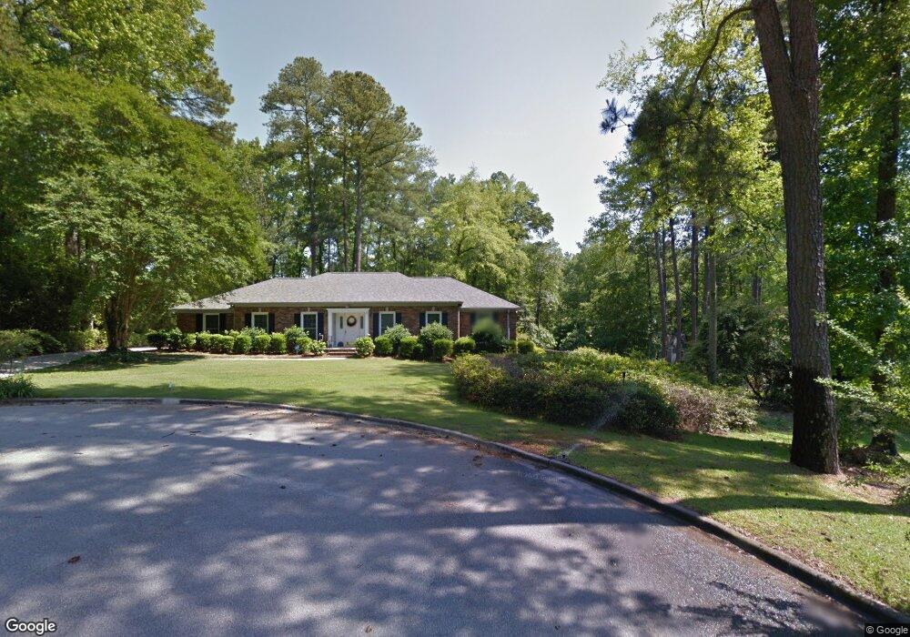
This home is located at 8141 Sir Lancelot Ct, Evans, GA 30809 and is currently estimated at $353,399, approximately $118 per square foot. 8141 Sir Lancelot Ct is a home located in Columbia County with nearby schools including Evans Elementary School, John F. Kennedy Middle School, and Evans Middle School.
Ownership History
Date
Name
Owned For
Owner Type
Purchase Details
Closed on
Oct 7, 2005
Sold by
Mccord Jacquelyn B
Bought by
Hopkins Ellis L and Hopkins Terisa D
Current Estimated Value
Home Financials for this Owner
Home Financials are based on the most recent Mortgage that was taken out on this home.
Original Mortgage
$216,300
Outstanding Balance
$114,336
Interest Rate
5.66%
Mortgage Type
New Conventional
Estimated Equity
$239,063
Create a Home Valuation Report for This Property
The Home Valuation Report is an in-depth analysis detailing your home's value as well as a comparison with similar homes in the area
Home Values in the Area
Average Home Value in this Area
Purchase History
| Date | Buyer | Sale Price | Title Company |
|---|---|---|---|
| Hopkins Ellis L | $254,500 | -- |
Source: Public Records
Mortgage History
| Date | Status | Borrower | Loan Amount |
|---|---|---|---|
| Open | Hopkins Ellis L | $216,300 |
Source: Public Records
Tax History Compared to Growth
Tax History
| Year | Tax Paid | Tax Assessment Tax Assessment Total Assessment is a certain percentage of the fair market value that is determined by local assessors to be the total taxable value of land and additions on the property. | Land | Improvement |
|---|---|---|---|---|
| 2025 | $1,177 | $148,841 | $36,444 | $112,397 |
| 2024 | $3,619 | $144,472 | $36,444 | $108,028 |
| 2023 | $907 | $121,453 | $26,324 | $95,129 |
| 2022 | $912 | $100,664 | $24,124 | $76,540 |
| 2021 | $850 | $88,881 | $19,394 | $69,487 |
| 2020 | $867 | $87,222 | $23,684 | $63,538 |
| 2019 | $852 | $85,654 | $23,684 | $61,970 |
| 2018 | $753 | $74,441 | $17,524 | $56,917 |
| 2017 | $757 | $74,024 | $17,524 | $56,500 |
| 2016 | $691 | $75,017 | $17,500 | $57,517 |
| 2015 | $747 | $81,486 | $21,460 | $60,026 |
| 2014 | $2,455 | $89,648 | $21,460 | $68,188 |
Source: Public Records
Map
Nearby Homes
- 4421 Hereford Farm Rd
- 525 Pheasant Run Dr
- 464 Rachel Dr
- 489 Connemara Trail
- 4560 Mulberry Creek Dr
- 4586 Oxford Ct
- 854 Sparkleberry Rd
- 00 N Belair Rd
- 4569 Gray Ln
- 4597 Gray Ln
- 2975 Rosewood Dr
- 726 Whitney Shoals Rd
- 586 Gibbs Rd
- 4648 Leeward Dr
- 4489 Woodberry Ct
- 829 Woodberry Dr
- 4670 La Pointe
- 322 Sandhills Ln
- 4664 La Pointe
- 1 Bohler Ave
- 8139 Sir Lancelot Ct
- 8146 Sir Lancelot Ct
- 8137 Sir Lancelot Ct
- 8144 Sir Lancelot Ct
- 286 Lake Jean Dr
- 8142 Sir Lancelot Ct
- 292 Lake Jean Dr
- 8138 Sir Lancelot Ct
- 294 Lake Jean Dr
- 269 Lake Jean Dr
- 8133 Sir Lancelot Ct
- 472 Lawrence Dr
- 298 Lake Jean Dr
- 291 Lake Jean Dr
- 291 Lake Jean Dr
- 282 Lake Jean Dr
- 293 Lake Jean Dr
- 8119 Sir Galahad Dr
- 8117 Sir Galahad Dr
- 8127 Sir Galahad Dr