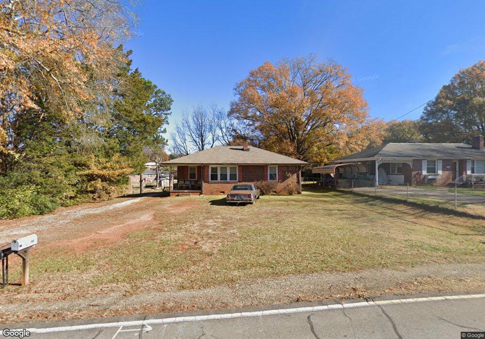
816 Ferry St Anderson, SC 29626
Estimated Value: $110,563 - $167,000
3
Beds
1
Bath
1,052
Sq Ft
$126/Sq Ft
Est. Value
About This Home
This home is located at 816 Ferry St, Anderson, SC 29626 and is currently estimated at $132,891, approximately $126 per square foot. 816 Ferry St is a home located in Anderson County with nearby schools including Varennes Elementary School, Robert Anderson Middle School, and Westside High School.
Ownership History
Date
Name
Owned For
Owner Type
Purchase Details
Closed on
Feb 28, 2024
Sold by
Oakes Paul A
Bought by
Oakes Christine
Current Estimated Value
Purchase Details
Closed on
Jan 6, 2024
Sold by
Oakes Harris Dewitt
Bought by
Oakes Paul A
Purchase Details
Closed on
Apr 10, 2012
Sold by
Witt David R
Bought by
Oakes Harris
Purchase Details
Closed on
Apr 6, 2012
Sold by
Witt Greg and Witt William D
Bought by
Oakes Harris
Purchase Details
Closed on
Apr 3, 2012
Sold by
Elgin Debra W
Bought by
Elgin Debra W
Purchase Details
Closed on
Oct 16, 2006
Sold by
Witt Greg
Bought by
Witt James Lloyd and Witt Greg
Create a Home Valuation Report for This Property
The Home Valuation Report is an in-depth analysis detailing your home's value as well as a comparison with similar homes in the area
Home Values in the Area
Average Home Value in this Area
Purchase History
| Date | Buyer | Sale Price | Title Company |
|---|---|---|---|
| Oakes Christine | -- | South Carolina Title | |
| Oakes Paul A | -- | None Listed On Document | |
| Oakes Harris | $208 | -- | |
| Oakes Harris | $4,791 | -- | |
| Elgin Debra W | -- | -- | |
| Witt James Lloyd | -- | None Available |
Source: Public Records
Tax History Compared to Growth
Tax History
| Year | Tax Paid | Tax Assessment Tax Assessment Total Assessment is a certain percentage of the fair market value that is determined by local assessors to be the total taxable value of land and additions on the property. | Land | Improvement |
|---|---|---|---|---|
| 2024 | $1,442 | $4,010 | $480 | $3,530 |
| 2023 | $1,442 | $2,680 | $320 | $2,360 |
| 2022 | $409 | $2,680 | $320 | $2,360 |
| 2021 | $384 | $2,440 | $280 | $2,160 |
| 2020 | $379 | $2,440 | $280 | $2,160 |
| 2019 | $1,292 | $3,650 | $420 | $3,230 |
| 2018 | $1,276 | $3,650 | $420 | $3,230 |
| 2017 | -- | $3,650 | $420 | $3,230 |
| 2016 | $1,218 | $3,550 | $390 | $3,160 |
| 2015 | $1,226 | $3,550 | $390 | $3,160 |
| 2014 | $1,205 | $3,550 | $390 | $3,160 |
Source: Public Records
Map
Nearby Homes
- 3308 New Pond Rd
- 00 Hwy 28 Bypass New Pond Rd
- AUBURN Plan at Shockley Bend
- BENNINGTON Plan at Shockley Bend
- BERKSHIRE Plan at Shockley Bend
- 312 W Roosevelt Dr
- 431 Lewis St
- 505 Lewis St
- 612 Martha Dr
- 110 Dixie Dr
- 112 Dixie Dr
- 114 Dixie Dr
- 46 S Lyons St
- 126 Rubin Ave
- 2920 Chambers Rd
- 313 Hugh St
- 112 Flowe Rd
- 203 Cromer Rd Unit A & B
- 210 E Roosevelt Dr
- 207 Hillman Dr