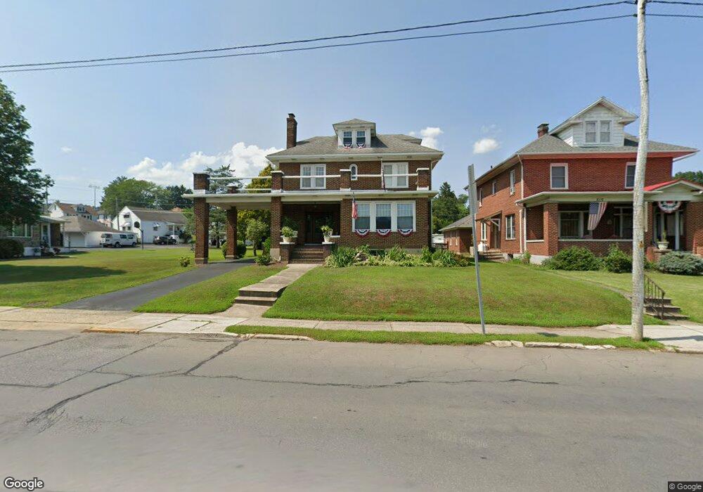
818 Mahoning St Lehighton, PA 18235
Estimated Value: $273,000 - $350,000
4
Beds
2
Baths
2,250
Sq Ft
$138/Sq Ft
Est. Value
About This Home
This home is located at 818 Mahoning St, Lehighton, PA 18235 and is currently estimated at $309,680, approximately $137 per square foot. 818 Mahoning St is a home located in Carbon County with nearby schools including Lehighton Area High School, Sts. Peter & Paul School, and Valley Ridge Academy.
Ownership History
Date
Name
Owned For
Owner Type
Purchase Details
Closed on
Dec 6, 2017
Sold by
Walker David L and Walker April F
Bought by
Walker April P
Current Estimated Value
Home Financials for this Owner
Home Financials are based on the most recent Mortgage that was taken out on this home.
Original Mortgage
$129,629
Outstanding Balance
$107,486
Interest Rate
3.37%
Mortgage Type
FHA
Estimated Equity
$202,194
Purchase Details
Closed on
Aug 2, 2011
Sold by
Wasilko Thomas M and Wasilko Shirley L
Bought by
Phillips Beth Anne
Home Financials for this Owner
Home Financials are based on the most recent Mortgage that was taken out on this home.
Original Mortgage
$120,000
Interest Rate
4.51%
Mortgage Type
New Conventional
Create a Home Valuation Report for This Property
The Home Valuation Report is an in-depth analysis detailing your home's value as well as a comparison with similar homes in the area
Home Values in the Area
Average Home Value in this Area
Purchase History
| Date | Buyer | Sale Price | Title Company |
|---|---|---|---|
| Walker April P | -- | None Available | |
| Phillips Beth Anne | $200,000 | None Available |
Source: Public Records
Mortgage History
| Date | Status | Borrower | Loan Amount |
|---|---|---|---|
| Open | Walker April P | $129,629 | |
| Closed | Phillips Beth Anne | $120,000 |
Source: Public Records
Tax History Compared to Growth
Tax History
| Year | Tax Paid | Tax Assessment Tax Assessment Total Assessment is a certain percentage of the fair market value that is determined by local assessors to be the total taxable value of land and additions on the property. | Land | Improvement |
|---|---|---|---|---|
| 2025 | $4,918 | $61,650 | $5,450 | $56,200 |
| 2024 | $4,671 | $61,650 | $5,450 | $56,200 |
| 2023 | $4,625 | $61,650 | $5,450 | $56,200 |
| 2022 | $4,625 | $61,650 | $5,450 | $56,200 |
| 2021 | $4,463 | $61,650 | $5,450 | $56,200 |
| 2020 | $4,354 | $61,650 | $5,450 | $56,200 |
| 2019 | $4,169 | $61,650 | $5,450 | $56,200 |
| 2018 | $4,077 | $61,650 | $5,450 | $56,200 |
| 2017 | $4,046 | $61,650 | $5,450 | $56,200 |
| 2016 | -- | $61,650 | $5,450 | $56,200 |
| 2015 | -- | $61,650 | $5,450 | $56,200 |
| 2014 | -- | $61,650 | $5,450 | $56,200 |
Source: Public Records
Map
Nearby Homes
- 639 Iron St
- 522 Iron St
- 0 Emily Plan at Summit Point Unit PACC2005480
- 0 Copper Beech Plan at Summit Ridge Unit PACC2005478
- 0 Black Cherry Plan at Summit Ridge Unit PACC2005474
- 0 Ridge
- 470 N 8th St
- 410 S 8th St
- 193 S 4th St
- 193 S 4th St Unit 191-193
- 117 N 4th St
- 196 S 3rd St
- 215 N 4th St
- 17 Mahoning Dr E
- 230 S 2nd St
- 236 S 2nd St
- 231 Coal St
- 344 Ochre St
- 12 2nd Ave
- 142 Bankway St