Estimated Value: $187,000 - $344,000
--
Bed
--
Bath
--
Sq Ft
10
Acres
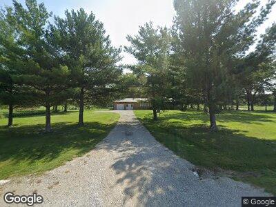
About This Home
This home is located at 8180 Garrett Rd, Alma, IL 62807 and is currently estimated at $246,744. 8180 Garrett Rd is a home with nearby schools including South Central Elementary School, South Central Middle School, and South Central High School.
Ownership History
Date
Name
Owned For
Owner Type
Purchase Details
Closed on
Sep 20, 2021
Sold by
Hiestand Colton E and Hiestand Sierra S
Bought by
Courson Dalton L and Hilmes Katlyn M
Current Estimated Value
Home Financials for this Owner
Home Financials are based on the most recent Mortgage that was taken out on this home.
Original Mortgage
$180,500
Outstanding Balance
$168,478
Interest Rate
2.8%
Mortgage Type
New Conventional
Estimated Equity
$124,236
Purchase Details
Closed on
Aug 30, 2018
Sold by
Garrett M Suzanne
Bought by
Hiestand Colton E and Hierstand Sierra S
Home Financials for this Owner
Home Financials are based on the most recent Mortgage that was taken out on this home.
Original Mortgage
$90,000
Interest Rate
4.5%
Mortgage Type
New Conventional
Create a Home Valuation Report for This Property
The Home Valuation Report is an in-depth analysis detailing your home's value as well as a comparison with similar homes in the area
Home Values in the Area
Average Home Value in this Area
Purchase History
| Date | Buyer | Sale Price | Title Company |
|---|---|---|---|
| Courson Dalton L | $190,000 | Jessica N Hudspeth Hudspeth La | |
| Hiestand Colton E | $120,000 | None Available |
Source: Public Records
Mortgage History
| Date | Status | Borrower | Loan Amount |
|---|---|---|---|
| Open | Courson Dalton L | $180,500 | |
| Previous Owner | Hiestand Colton E | $93,300 | |
| Previous Owner | Hiestand Colton E | $24,900 | |
| Previous Owner | Hiestand Colton E | $90,000 |
Source: Public Records
Tax History Compared to Growth
Tax History
| Year | Tax Paid | Tax Assessment Tax Assessment Total Assessment is a certain percentage of the fair market value that is determined by local assessors to be the total taxable value of land and additions on the property. | Land | Improvement |
|---|---|---|---|---|
| 2023 | $3,792 | $56,760 | $14,780 | $41,980 |
| 2022 | $3,402 | $51,600 | $13,440 | $38,160 |
| 2021 | $2,656 | $39,776 | $4,116 | $35,660 |
| 2020 | $2,493 | $38,531 | $3,891 | $34,640 |
| 2019 | $2,486 | $37,086 | $3,666 | $33,420 |
| 2018 | $2,177 | $36,951 | $3,531 | $33,420 |
| 2017 | $2,210 | $36,175 | $3,385 | $32,790 |
| 2016 | $2,148 | $34,766 | $3,186 | $31,580 |
| 2015 | $21 | $34,695 | $3,115 | $31,580 |
| 2012 | $26 | $42,080 | $2,110 | $39,970 |
Source: Public Records
Map
Nearby Homes
- 8411 Brimberry Rd
- 1195 Kinoka Rd
- 4636 Kinoka Rd
- 4544 Vermundy Rd
- 3975 Hicks Rd
- 721 Illinois St
- 4347 Alma Hatchery Rd
- 000 Bailey Rd
- 517 Fremont St
- 401 S A St
- 105 N Elm St
- 309 E Clinton Ave
- 100 Holman St
- 1987 Charleston Rd
- 000 Wisher Rd
- 5 Lakedale Dr
- 370 Northwood Ln
- 1579 Charleston Rd
- 205 E Jennings St
- 226 E William St