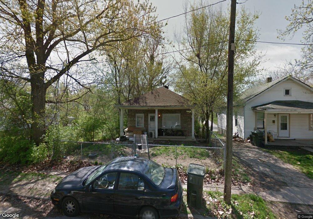
819 E Rogers Ave Decatur, IL 62521
Mueller Park NeighborhoodEstimated Value: $33,000 - $56,000
--
Bed
--
Bath
864
Sq Ft
$53/Sq Ft
Est. Value
About This Home
This home is located at 819 E Rogers Ave, Decatur, IL 62521 and is currently estimated at $45,951, approximately $53 per square foot. 819 E Rogers Ave is a home located in Macon County with nearby schools including South Shores Elementary School, Stephen Decatur Middle School, and St. Patrick School.
Ownership History
Date
Name
Owned For
Owner Type
Purchase Details
Closed on
Dec 30, 2021
Sold by
Sempkins Brian
Bought by
Whitfield Calvin
Current Estimated Value
Purchase Details
Closed on
Jul 19, 2021
Sold by
Corrington Darrel
Bought by
Simpkins Brian
Purchase Details
Closed on
Apr 12, 2016
Sold by
Macon County
Bought by
Corrington Darrel
Purchase Details
Closed on
Aug 21, 2015
Sold by
Platinum Real Estate Group
Bought by
Macon County
Purchase Details
Closed on
Nov 12, 2003
Purchase Details
Closed on
Jun 1, 1994
Create a Home Valuation Report for This Property
The Home Valuation Report is an in-depth analysis detailing your home's value as well as a comparison with similar homes in the area
Home Values in the Area
Average Home Value in this Area
Purchase History
| Date | Buyer | Sale Price | Title Company |
|---|---|---|---|
| Whitfield Calvin | -- | None Listed On Document | |
| Simpkins Brian | -- | None Available | |
| Corrington Darrel | -- | None Available | |
| Macon County | -- | None Available | |
| -- | -- | -- | |
| -- | $5,700 | -- |
Source: Public Records
Tax History Compared to Growth
Tax History
| Year | Tax Paid | Tax Assessment Tax Assessment Total Assessment is a certain percentage of the fair market value that is determined by local assessors to be the total taxable value of land and additions on the property. | Land | Improvement |
|---|---|---|---|---|
| 2024 | $574 | $5,932 | $513 | $5,419 |
| 2023 | $569 | $5,722 | $495 | $5,227 |
| 2022 | $542 | $5,295 | $458 | $4,837 |
| 2021 | $509 | $4,945 | $428 | $4,517 |
| 2020 | $501 | $4,715 | $408 | $4,307 |
| 2019 | $501 | $4,715 | $408 | $4,307 |
| 2018 | $445 | $4,231 | $437 | $3,794 |
| 2017 | $455 | $4,344 | $449 | $3,895 |
| 2016 | $0 | $98 | $49 | $49 |
| 2015 | $441 | $4,311 | $446 | $3,865 |
| 2014 | $412 | $4,269 | $442 | $3,827 |
| 2013 | $423 | $4,430 | $459 | $3,971 |
Source: Public Records
Map
Nearby Homes
- 1232 S Silas St
- 1347 S Maffit St
- 1283 S Illinois St
- 1263 E Dickinson Ave
- 1104 E Moore St
- 409 Southmoreland Place
- 1408 E Buena Vista Ave
- 318 S Martin Luther King Junior Dr
- 1232 E Johns Ave
- 22 Eastmoreland Ln
- 632 S 17th St
- 1952 Florida Ct
- 1605 E Clay St
- 580 Powers Ln
- 1155 S 20th St
- 530 Powers Ln
- 1127 S 21st St
- 1136 S 21st St
- 1764 E Johns Ave
- 1645 E Wood St
- 815 E Rogers Ave
- 829 E Rogers Ave
- 805 E Rogers Ave
- 801 E Rogers Ave
- 833 E Rogers Ave
- 1140 S Hilton St
- 845 E Rogers Ave
- 810 E Rogers Ave
- 1148 S Hilton St
- 830 E Rogers Ave
- 759 E Rogers Ave
- 770 E Rogers Ave
- 1103 S Maffit St
- 766 E Rogers Ave
- 1152 S Hilton St
- 1117 S Maffit St
- 1087 S Maffit St
- 758 E Rogers Ave
- 1168 S Hilton St
- 743 E Rogers Ave