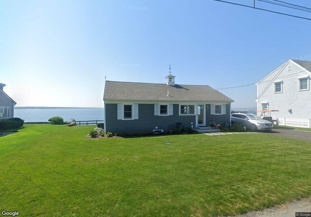
82 Captains Row Mashnee Isl Bourne, MA 02532
Estimated Value: $907,000 - $2,119,000
3
Beds
2
Baths
1,750
Sq Ft
$821/Sq Ft
Est. Value
About This Home
This home is located at 82 Captains Row Mashnee Isl, Bourne, MA 02532 and is currently estimated at $1,436,361, approximately $820 per square foot. 82 Captains Row Mashnee Isl is a home located in Barnstable County with nearby schools including Bourne High School.
Ownership History
Date
Name
Owned For
Owner Type
Purchase Details
Closed on
Jan 13, 2025
Sold by
Moore William C and Moore Marilou J
Bought by
Moore Ft and Moore
Current Estimated Value
Purchase Details
Closed on
Jan 21, 2021
Sold by
Jean A Chinzi Bourne Irt and Moore
Bought by
Moore Marilou J and Moore William C
Purchase Details
Closed on
Dec 5, 2012
Sold by
Chinzi Jean A
Bought by
Jean A Chinzi Bourne I A and Jean Moore
Purchase Details
Closed on
Jan 15, 2008
Sold by
Chinzi Jean A
Bought by
82 Captains Row Rt and Chinzi
Create a Home Valuation Report for This Property
The Home Valuation Report is an in-depth analysis detailing your home's value as well as a comparison with similar homes in the area
Purchase History
| Date | Buyer | Sale Price | Title Company |
|---|---|---|---|
| Moore Ft | -- | None Available | |
| Moore Ft | -- | None Available | |
| Moore Marilou J | -- | None Available | |
| Moore Marilou J | -- | None Available | |
| Moore Marilou J | -- | None Available | |
| Jean A Chinzi Bourne I A | -- | -- | |
| Chinzi Jean A | -- | -- | |
| Jean A Chinzi Bourne I A | -- | -- | |
| 82 Captains Row Rt | -- | -- | |
| 82 Captains Row Rt | -- | -- | |
| Jean A Chinzi Bourne I A | -- | -- | |
| 82 Captains Row Rt | -- | -- |
Source: Public Records
Mortgage History
| Date | Status | Borrower | Loan Amount |
|---|---|---|---|
| Previous Owner | 82 Captains Row Rt | $129,000 |
Source: Public Records
Tax History
| Year | Tax Paid | Tax Assessment Tax Assessment Total Assessment is a certain percentage of the fair market value that is determined by local assessors to be the total taxable value of land and additions on the property. | Land | Improvement |
|---|---|---|---|---|
| 2025 | $10,001 | $1,280,600 | $971,500 | $309,100 |
| 2024 | $9,780 | $1,219,500 | $925,200 | $294,300 |
| 2023 | $9,154 | $1,039,100 | $818,800 | $220,300 |
| 2022 | $9,125 | $904,400 | $724,600 | $179,800 |
| 2021 | $8,736 | $811,100 | $659,400 | $151,700 |
| 2020 | $8,566 | $797,600 | $653,200 | $144,400 |
| 2019 | $8,297 | $789,400 | $653,200 | $136,200 |
| 2018 | $7,858 | $745,500 | $622,100 | $123,400 |
| 2017 | $7,622 | $740,000 | $616,300 | $123,700 |
| 2016 | $7,667 | $754,600 | $650,500 | $104,100 |
| 2015 | $7,599 | $754,600 | $650,500 | $104,100 |
Source: Public Records
Map
Nearby Homes
- 248 Great Neck Rd
- 566 Shore Rd
- 14 Navajo Rd
- 35 Benedict Rd
- 200 Great Neck Rd
- 254 Barlows Landing Rd
- 203 County Rd
- 60 Bourne Neck Dr
- 709 County Rd
- 16 Michael Rd
- 36B Starboard Dr Unit 36E
- 36B Starboard Dr Unit 36G
- 36B Starboard Dr Unit 36C
- 36B Starboard Dr Unit 36A
- 36B Starboard Dr Unit 36D
- 36B Starboard Dr Unit 36B
- 36B Starboard Dr Unit 36F
- 36B Starboard Dr Unit 36H
- 3 Carleton St Unit 3
- 23 Starboard Dr Unit Lot 50
- 82 Captains Row
- 82 Captains Row
- 83 Captains Row
- 81 Captains Row
- 114 Captains Row
- 115 Captains Row
- 80 Captains Row
- 80 Captains Row
- 112 Rope Walk Rd
- 84 Captains Row
- 113 Mashnee Rd
- 146 Mashnee Rd
- 77 Captains Row
- 77 Captains Row
- 110 Rope Walk Rd
- 144 Mashnee Rd
- 78 Captains Row
- 111 Mashnee Rd
- 149 Leeward Rd
- 153 Captains Row
Your Personal Tour Guide
Ask me questions while you tour the home.