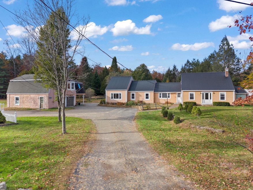
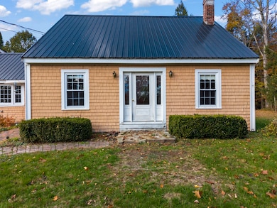
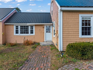
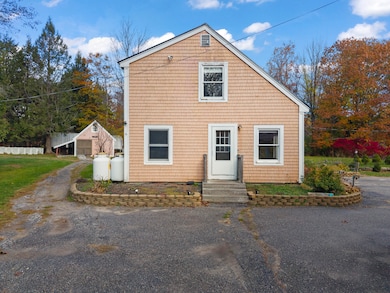
82 Carll Rd Buxton, ME 04093
Estimated payment $3,357/month
Highlights
- 4.7 Acre Lot
- Wood Flooring
- No HOA
- Wooded Lot
- Main Floor Bedroom
- 2 Car Garage
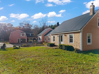
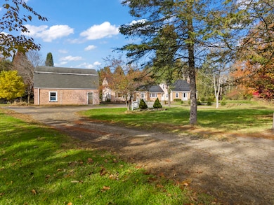
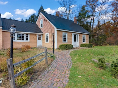
About This Home
Endless Possibilities!
Discover this beautifully maintained 4-bedroom home set on 4.7 acres of park-like grounds in the heart of Buxton. Thoughtfully landscaped and surrounded by mature trees, gardens, and a charming gazebo, this property offers both privacy and space to enjoy Maine's natural beauty.
Inside, the home features a flexible layout ideal for a variety of living arrangements, including the potential for an in-law suite or accessory dwelling unit (ADU). The bright, open kitchen and spacious living areas create a warm and welcoming atmosphere, while the generous bedrooms provide comfort for family or guests. Outside, you'll find multiple outbuildings perfect for hobbies, storage, or small livestock if the town allows, along with a detached garage that includes a workshop—ideal for projects, extra space, or ADU conversion. Whether you're looking for a multi-generational living setup, a small homestead, or simply a peaceful retreat, this property offers endless potential.
Enjoy the best of country living just a short drive from local shops, schools, and commuter routes to Portland and surrounding areas.
Home Details
Home Type
- Single Family
Est. Annual Taxes
- $4,952
Year Built
- Built in 1980
Lot Details
- 4.7 Acre Lot
- Rural Setting
- Level Lot
- Open Lot
- Wooded Lot
- Property is zoned Rural
Parking
- 2 Car Garage
Home Design
- 1,888 Sq Ft Home
- Wood Frame Construction
- Shingle Roof
- Wood Siding
- Shingle Siding
Flooring
- Wood
- Laminate
Bedrooms and Bathrooms
- 4 Bedrooms
- Main Floor Bedroom
- 2 Full Bathrooms
Unfinished Basement
- Basement Fills Entire Space Under The House
- Partial Basement
- Interior Basement Entry
Utilities
- No Cooling
- Heating System Mounted To A Wall or Window
- Private Water Source
- Private Sewer
Community Details
- No Home Owners Association
Listing and Financial Details
- Tax Lot 64-16
- Assessor Parcel Number BUXT-000007-000000-000064-000016
Map
Home Values in the Area
Average Home Value in this Area
Tax History
| Year | Tax Paid | Tax Assessment Tax Assessment Total Assessment is a certain percentage of the fair market value that is determined by local assessors to be the total taxable value of land and additions on the property. | Land | Improvement |
|---|---|---|---|---|
| 2024 | $4,952 | $450,600 | $177,200 | $273,400 |
| 2023 | $6,178 | $592,300 | $177,200 | $415,100 |
| 2022 | $6,122 | $597,900 | $177,200 | $420,700 |
| 2021 | $5,527 | $382,218 | $104,200 | $278,018 |
| 2020 | $5,573 | $382,218 | $104,200 | $278,018 |
| 2019 | $5,034 | $339,700 | $104,200 | $235,500 |
| 2018 | $4,803 | $339,700 | $104,200 | $235,500 |
| 2017 | $4,620 | $339,700 | $104,200 | $235,500 |
| 2016 | $0 | $339,700 | $104,200 | $235,500 |
| 2015 | -- | $339,700 | $104,200 | $235,500 |
| 2014 | $4,286 | $342,900 | $104,200 | $238,700 |
| 2013 | $4,286 | $342,900 | $104,200 | $238,700 |
Property History
| Date | Event | Price | List to Sale | Price per Sq Ft |
|---|---|---|---|---|
| 11/25/2025 11/25/25 | Price Changed | $559,000 | -2.8% | $296 / Sq Ft |
| 11/07/2025 11/07/25 | Price Changed | $575,000 | -1.7% | $305 / Sq Ft |
| 11/04/2025 11/04/25 | Price Changed | $585,000 | -2.3% | $310 / Sq Ft |
| 10/30/2025 10/30/25 | For Sale | $599,000 | -- | $317 / Sq Ft |
Purchase History
| Date | Type | Sale Price | Title Company |
|---|---|---|---|
| Personal Reps Deed | -- | None Available | |
| Quit Claim Deed | -- | -- | |
| Interfamily Deed Transfer | -- | -- |
Mortgage History
| Date | Status | Loan Amount | Loan Type |
|---|---|---|---|
| Previous Owner | $540,000 | Adjustable Rate Mortgage/ARM | |
| Previous Owner | $25,000 | Unknown | |
| Previous Owner | $214,500 | Adjustable Rate Mortgage/ARM |
Source: Maine Listings
MLS Number: 1642355
APN: BUXT-000007-000000-000064-000016
Disclaimer: Certain information contained herein is derived from information provided by parties other than Homes.com. All information provided is deemed reliable, but is not guaranteed to be accurate and should be independently verified.
![]() Listing data is derived in whole or in part from Maine Real Estate Information System, Inc. (d/b/a Maine Listings) and is for consumers' personal, noncommercial use only. Dimensions are approximate and not guaranteed. All data should be independently verified.
Listing data is derived in whole or in part from Maine Real Estate Information System, Inc. (d/b/a Maine Listings) and is for consumers' personal, noncommercial use only. Dimensions are approximate and not guaranteed. All data should be independently verified.
© 2025 Maine Real Estate Information System, Inc. All Rights Reserved. Equal Housing Opportunity.
Homes.com, LLC, 17600 Laguna Canyon Rd Irvine, CA 92618 (888)-952-6393
![]()
- 15 Winter St
- 90 Green Acres Dr
- 1306 Long Plains Rd
- 12 Richard Rd
- 9 Johnson Farm Rd
- 17 Johnson Farm Rd
- 38 Johnson Farm Rd
- 30 Joan Dixon Way
- 62 Emery Cir
- 28 E Wind Dr
- 6 Midnight Way
- 445 Portland Rd
- 00 Deering Dr
- 430 Narragansett Trail
- 9 Bonita Way
- 17 Boreal Dr
- 30 Boreal Dr
- 939 River Rd
- 742 River Rd
- 84 Tall Pine Dr
- 40 Turkey Ln Unit 2
- 73 State St
- 84 Johnson Rd Unit Main
- 139 Buck St
- 64 County Rd
- 364 Buxton Rd
- 2 New Gorham Rd Unit 2
- 39 W Pleasant St
- 6 Stockyard Dr
- 6-14 Island View Dr
- 20-24 Autumn Woods Dr
- 6-12 Jacqueline Way
- 16 Blue Spruce Farm Rd
- 762 Main St Unit 1
- 1 Ari Dr
- 9 Gambo Rd
- 9 Gambo Rd
- 5 Sherman Cir Unit 1
- 100 Gateway Blvd
- 2 Ashley Dr
