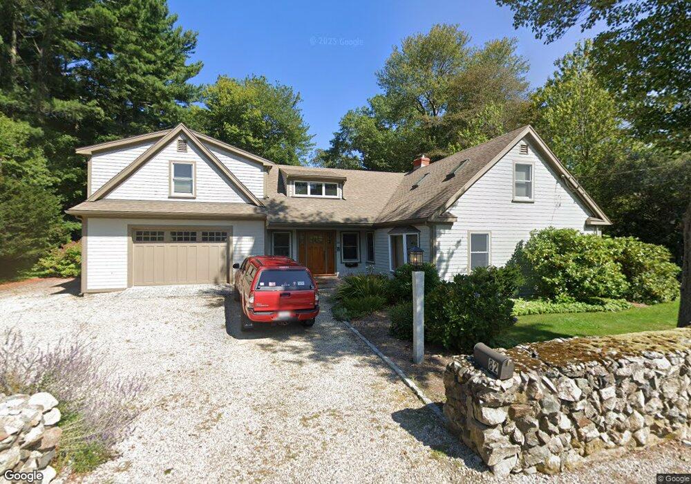
82 Elm St Scituate, MA 02066
Estimated Value: $1,043,000 - $1,305,607
3
Beds
2
Baths
1,723
Sq Ft
$687/Sq Ft
Est. Value
About This Home
This home is located at 82 Elm St, Scituate, MA 02066 and is currently estimated at $1,184,402, approximately $687 per square foot. 82 Elm St is a home located in Plymouth County with nearby schools including Cushing Elementary School, Lester J. Gates Middle School, and Scituate High School.
Ownership History
Date
Name
Owned For
Owner Type
Purchase Details
Closed on
Feb 24, 2006
Sold by
Crane John A and Crane Barbara J
Bought by
Glennon Joseph M and Glennon Katharine M
Current Estimated Value
Home Financials for this Owner
Home Financials are based on the most recent Mortgage that was taken out on this home.
Original Mortgage
$340,000
Interest Rate
6.17%
Mortgage Type
Purchase Money Mortgage
Purchase Details
Closed on
Aug 29, 1997
Sold by
Crane John A and Crane Barbara J
Bought by
Maheras John G and Maheras Susan T
Create a Home Valuation Report for This Property
The Home Valuation Report is an in-depth analysis detailing your home's value as well as a comparison with similar homes in the area
Home Values in the Area
Average Home Value in this Area
Purchase History
| Date | Buyer | Sale Price | Title Company |
|---|---|---|---|
| Glennon Joseph M | $582,500 | -- | |
| Maheras John G | $15,000 | -- |
Source: Public Records
Mortgage History
| Date | Status | Borrower | Loan Amount |
|---|---|---|---|
| Open | Maheras John G | $50,000 | |
| Open | Maheras John G | $334,000 | |
| Closed | Maheras John G | $340,000 | |
| Previous Owner | Maheras John G | $320,000 |
Source: Public Records
Tax History Compared to Growth
Tax History
| Year | Tax Paid | Tax Assessment Tax Assessment Total Assessment is a certain percentage of the fair market value that is determined by local assessors to be the total taxable value of land and additions on the property. | Land | Improvement |
|---|---|---|---|---|
| 2025 | $10,319 | $1,032,900 | $409,700 | $623,200 |
| 2024 | $10,267 | $991,000 | $372,400 | $618,600 |
| 2023 | $10,000 | $908,400 | $357,800 | $550,600 |
| 2022 | $10,000 | $792,400 | $330,400 | $462,000 |
| 2021 | $9,046 | $678,600 | $314,700 | $363,900 |
| 2020 | $8,770 | $649,600 | $302,600 | $347,000 |
| 2019 | $8,633 | $628,300 | $296,600 | $331,700 |
| 2018 | $8,553 | $613,100 | $294,300 | $318,800 |
| 2017 | $8,465 | $600,800 | $282,000 | $318,800 |
| 2016 | $8,149 | $576,300 | $257,500 | $318,800 |
| 2015 | $7,390 | $564,100 | $245,300 | $318,800 |
Source: Public Records
Map
Nearby Homes
- 111 Elm St
- 115 Elm St
- 18 James Way
- 290 Beaver Dam Rd
- 74 Tilden Rd
- 76 A Brook St
- 76 A Brook St Unit 1
- 148 Tilden Rd
- 13 Hornbeam Rd
- 50 First Parish Rd
- 12 Sassamon Rd
- 22 Kings Way
- 12 Richfield Rd
- 19 Ford Place Unit 3
- 19 Ford Place Unit 1
- 19 Ford Place Unit 4
- 116 Old Forge Rd
- 67 Greenfield Ln
- 12 Meeting House Ln Unit 308
- 91 Front St Unit 106