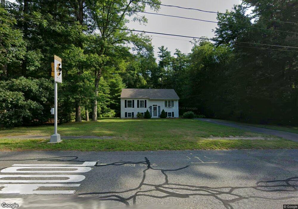
82 Pilgrim Rd Pembroke, MA 02359
Estimated Value: $587,147 - $642,000
--
Bed
2
Baths
925
Sq Ft
$672/Sq Ft
Est. Value
About This Home
This home is located at 82 Pilgrim Rd, Pembroke, MA 02359 and is currently estimated at $621,537, approximately $671 per square foot. 82 Pilgrim Rd is a home located in Plymouth County with nearby schools including Pembroke High School, Cadence Academy Preschool - Hanover, and Cardinal Cushing Centers.
Ownership History
Date
Name
Owned For
Owner Type
Purchase Details
Closed on
Feb 23, 2023
Sold by
Mulligan Ann T
Bought by
At Mulligan Lt
Current Estimated Value
Purchase Details
Closed on
May 20, 1987
Sold by
Hiltz Arthur D
Bought by
Maruca Joseph A
Home Financials for this Owner
Home Financials are based on the most recent Mortgage that was taken out on this home.
Original Mortgage
$106,000
Interest Rate
9.48%
Mortgage Type
Purchase Money Mortgage
Create a Home Valuation Report for This Property
The Home Valuation Report is an in-depth analysis detailing your home's value as well as a comparison with similar homes in the area
Home Values in the Area
Average Home Value in this Area
Purchase History
| Date | Buyer | Sale Price | Title Company |
|---|---|---|---|
| At Mulligan Lt | -- | None Available | |
| Maruca Joseph A | $132,900 | -- |
Source: Public Records
Mortgage History
| Date | Status | Borrower | Loan Amount |
|---|---|---|---|
| Previous Owner | Maruca Joseph A | $110,000 | |
| Previous Owner | Maruca Joseph A | $100,500 | |
| Previous Owner | Maruca Joseph A | $106,000 |
Source: Public Records
Tax History Compared to Growth
Tax History
| Year | Tax Paid | Tax Assessment Tax Assessment Total Assessment is a certain percentage of the fair market value that is determined by local assessors to be the total taxable value of land and additions on the property. | Land | Improvement |
|---|---|---|---|---|
| 2025 | $6,827 | $568,000 | $305,200 | $262,800 |
| 2024 | $6,736 | $559,900 | $300,000 | $259,900 |
| 2023 | $6,692 | $526,100 | $285,200 | $240,900 |
| 2022 | $6,165 | $435,700 | $235,200 | $200,500 |
| 2021 | $5,901 | $404,700 | $220,000 | $184,700 |
| 2020 | $5,795 | $399,900 | $215,200 | $184,700 |
| 2019 | $5,646 | $386,700 | $210,000 | $176,700 |
| 2018 | $5,575 | $374,400 | $210,000 | $164,400 |
| 2017 | $5,447 | $360,700 | $195,200 | $165,500 |
| 2016 | $5,231 | $342,800 | $180,000 | $162,800 |
| 2015 | $4,953 | $336,000 | $170,000 | $166,000 |
Source: Public Records
Map
Nearby Homes
- 218 Schoosett St
- 46 Lorna Ave
- 31 Hillcrest Dr
- 66 Hemlock Dr
- 261 Washington St
- 15 Kings Terrace
- 33 Barker Square Dr Unit 33
- 172 Washington St
- 15 Bagnell Dr Unit 15
- 21 Union St
- 5 Royal Dane Dr Unit 46
- 55 Shipyard Ln
- 10 Royal Dane Dr Unit 88
- 133 Brigantine Cir
- 547 Washington St Unit A10
- 21 Chowdermarch St
- 451 School St Unit 5-2
- 40 Fairwood Dr
- 387 North St
- 17 Sherman Way