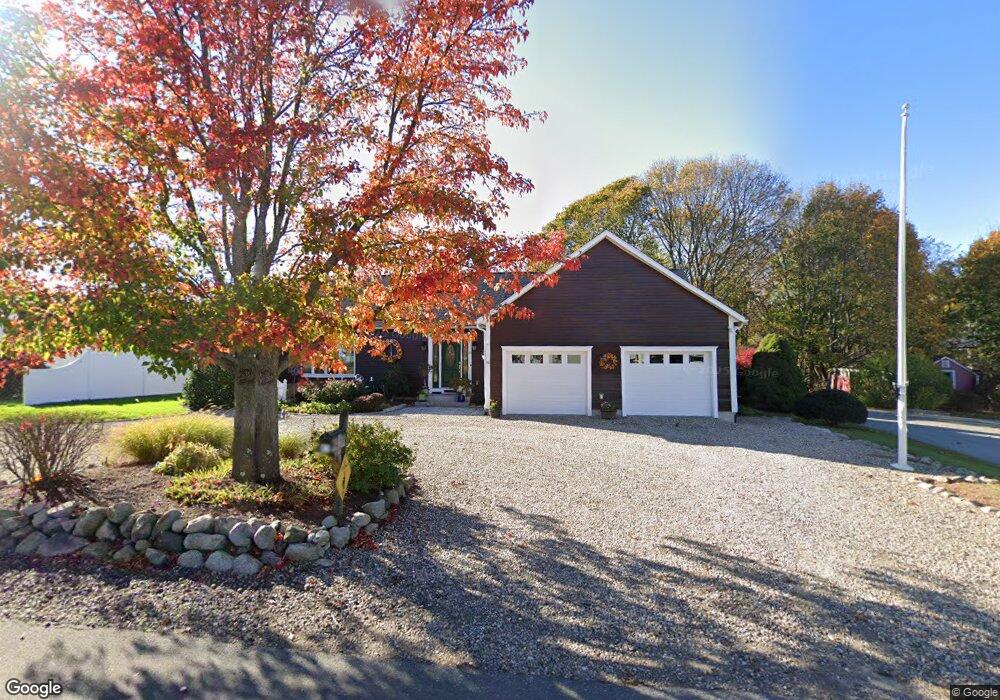
82 Wheeler St Gloucester, MA 01930
Riverview NeighborhoodEstimated Value: $854,629 - $1,084,000
2
Beds
3
Baths
1,974
Sq Ft
$478/Sq Ft
Est. Value
About This Home
This home is located at 82 Wheeler St, Gloucester, MA 01930 and is currently estimated at $943,907, approximately $478 per square foot. 82 Wheeler St is a home located in Essex County with nearby schools including Beeman Memorial, Ralph B O'maley Middle School, and Gloucester High School.
Ownership History
Date
Name
Owned For
Owner Type
Purchase Details
Closed on
Jan 9, 2025
Sold by
Richard B Pino Ret and Pino
Bought by
Ruth E Pino Ret and Pino
Current Estimated Value
Purchase Details
Closed on
Aug 4, 2015
Sold by
Sullivan Thomas H and Sullivan Susan E
Bought by
Sullivan Thomas H
Purchase Details
Closed on
Sep 3, 2014
Sold by
Pino Ruth E and Pino Richard B
Bought by
Richard B Pino Ret and Pino
Purchase Details
Closed on
Feb 29, 2000
Sold by
Dexter H Clark and Dexter Stephen F
Bought by
Pino Ruth E and Pino Richard B
Purchase Details
Closed on
Dec 21, 1999
Sold by
Dexter Eleanor F Est
Bought by
Sullivan Susan E
Create a Home Valuation Report for This Property
The Home Valuation Report is an in-depth analysis detailing your home's value as well as a comparison with similar homes in the area
Home Values in the Area
Average Home Value in this Area
Purchase History
| Date | Buyer | Sale Price | Title Company |
|---|---|---|---|
| Ruth E Pino Ret | -- | None Available | |
| Ruth E Pino Ret | -- | None Available | |
| Ruth E Pino Ret | -- | None Available | |
| Sullivan Thomas H | -- | -- | |
| Sullivan Thomas H | -- | -- | |
| Richard B Pino Ret | -- | -- | |
| Richard B Pino Ret | -- | -- | |
| Pino Ruth E | $102,000 | -- | |
| Pino Ruth E | $102,000 | -- | |
| Sullivan Susan E | $232,234 | -- | |
| Sullivan Susan E | $232,234 | -- |
Source: Public Records
Mortgage History
| Date | Status | Borrower | Loan Amount |
|---|---|---|---|
| Previous Owner | Sullivan Susan E | $116,000 | |
| Previous Owner | Sullivan Susan E | $125,000 | |
| Previous Owner | Sullivan Susan E | $50,000 |
Source: Public Records
Tax History
| Year | Tax Paid | Tax Assessment Tax Assessment Total Assessment is a certain percentage of the fair market value that is determined by local assessors to be the total taxable value of land and additions on the property. | Land | Improvement |
|---|---|---|---|---|
| 2025 | $7,067 | $727,100 | $245,300 | $481,800 |
| 2024 | $6,994 | $718,800 | $233,600 | $485,200 |
| 2023 | $7,043 | $665,100 | $208,600 | $456,500 |
| 2022 | $6,604 | $563,000 | $177,300 | $385,700 |
| 2021 | $6,660 | $535,400 | $161,200 | $374,200 |
| 2020 | $6,380 | $517,400 | $161,200 | $356,200 |
| 2019 | $6,394 | $503,900 | $161,200 | $342,700 |
| 2018 | $6,384 | $493,700 | $161,200 | $332,500 |
| 2017 | $6,219 | $471,500 | $153,500 | $318,000 |
| 2016 | $5,897 | $433,300 | $154,000 | $279,300 |
| 2015 | $5,800 | $424,900 | $154,000 | $270,900 |
Source: Public Records
Map
Nearby Homes
- 13 Honeysuckle Rd
- 3 Deacon Farm Ln
- 2 Breezy Point Rd
- 31 Echo Ave
- 672 Washington St
- 167 Atlantic St
- 178 Atlantic St
- 226 Atlantic St
- 13 Mystic Ave
- 8 Mystic Ave
- 6 Monroe Ct
- 98 Maplewood Ave
- 9 Cleveland Place
- 12 Arthur St
- 40 Sargent St
- 15 Harvard St
- 145 Essex Ave Unit 402
- 5 Samoset Rd Unit B
- 19 Trask St Unit 2
- 24 Cobblestone Ln Unit 603
- 80 Wheeler St
- 84 Wheeler St
- 78 Wheeler St
- 81 Wheeler St
- 79 Wheeler St
- 83 Wheeler St
- 57 Thurston Point Rd
- 77 Wheeler St
- 61 Thurston Point Rd
- 2 Rose Ln
- 1 Rose Ln
- 1 Rose Ln Unit UB
- 76 Wheeler St
- 3 Grandview Rd
- 87 Wheeler St
- 4 Grandview Rd
- 4 Smokey Way
- 4 Rose Ln
- 5 Rose Ln
- 5 Rose Ln Unit Beautiful 1 bed 1 ba
Your Personal Tour Guide
Ask me questions while you tour the home.