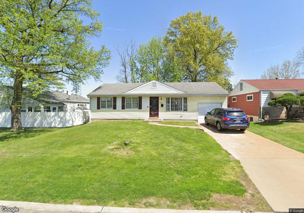
8206 General Sherman Ct Saint Louis, MO 63123
Estimated Value: $236,133 - $278,000
3
Beds
2
Baths
1,026
Sq Ft
$247/Sq Ft
Est. Value
About This Home
This home is located at 8206 General Sherman Ct, Saint Louis, MO 63123 and is currently estimated at $253,533, approximately $247 per square foot. 8206 General Sherman Ct is a home located in St. Louis County with nearby schools including Mesnier Primary School, Gotsch Intermediate School, and Rogers Middle School.
Ownership History
Date
Name
Owned For
Owner Type
Purchase Details
Closed on
Nov 30, 2012
Sold by
Faster House Llc
Bought by
Taylor Vickie V
Current Estimated Value
Home Financials for this Owner
Home Financials are based on the most recent Mortgage that was taken out on this home.
Original Mortgage
$117,826
Outstanding Balance
$82,132
Interest Rate
3.5%
Mortgage Type
FHA
Estimated Equity
$171,401
Purchase Details
Closed on
Aug 15, 2012
Sold by
Danter Matthew C
Bought by
Fasterhouse Llc
Home Financials for this Owner
Home Financials are based on the most recent Mortgage that was taken out on this home.
Original Mortgage
$77,000
Interest Rate
3.63%
Mortgage Type
Future Advance Clause Open End Mortgage
Purchase Details
Closed on
Jun 6, 2007
Sold by
Danter Charles Edward and Danter Marie Cecilia
Bought by
Danter Matthew C and The Charles Edward Danter & Marie Cecili
Create a Home Valuation Report for This Property
The Home Valuation Report is an in-depth analysis detailing your home's value as well as a comparison with similar homes in the area
Home Values in the Area
Average Home Value in this Area
Purchase History
| Date | Buyer | Sale Price | Title Company |
|---|---|---|---|
| Taylor Vickie V | $120,000 | Integrity Land Title Co Inc | |
| Fasterhouse Llc | $77,000 | Title Partners Agency Llc | |
| Danter Matthew C | -- | None Available |
Source: Public Records
Mortgage History
| Date | Status | Borrower | Loan Amount |
|---|---|---|---|
| Open | Taylor Vickie V | $117,826 | |
| Previous Owner | Fasterhouse Llc | $77,000 |
Source: Public Records
Tax History Compared to Growth
Tax History
| Year | Tax Paid | Tax Assessment Tax Assessment Total Assessment is a certain percentage of the fair market value that is determined by local assessors to be the total taxable value of land and additions on the property. | Land | Improvement |
|---|---|---|---|---|
| 2025 | $2,902 | $39,620 | $13,300 | $26,320 |
| 2024 | $2,902 | $35,750 | $8,850 | $26,900 |
| 2023 | $2,902 | $35,750 | $8,850 | $26,900 |
| 2022 | $2,659 | $30,840 | $9,750 | $21,090 |
| 2021 | $2,597 | $30,840 | $9,750 | $21,090 |
| 2020 | $2,542 | $28,160 | $8,700 | $19,460 |
| 2019 | $2,521 | $28,160 | $8,700 | $19,460 |
| 2018 | $2,334 | $23,030 | $6,080 | $16,950 |
| 2017 | $2,320 | $23,030 | $6,080 | $16,950 |
| 2016 | $2,017 | $21,260 | $4,540 | $16,720 |
| 2015 | $2,022 | $21,260 | $4,540 | $16,720 |
| 2014 | $2,119 | $22,190 | $5,340 | $16,850 |
Source: Public Records
Map
Nearby Homes
- 7101 Fernbrook Dr
- 7123 Craighill Dr
- 7243 General Sherman Ln
- 8415 Rockhaven Ln
- 8400 New Hampshire Ave
- 7936 Radnor Dr
- 6540 Lawnside Dr
- 8613 Carriage Way Dr
- 6843 Preservation Pkwy
- 6830 Preservation Pkwy
- 6819 Preservation Pkwy
- 7601 General Sheridan Ln
- 8215 General Sheridan Ln
- 6804 Snowy Owl Ln
- 6728 Preservation Pkwy
- 739 Hurstgreen Rd
- 6724 Preservation Pkwy
- 6325 Sheppard Dr
- 6730 Snowy Owl Ln
- 7625 General Meade Ln
- 8210 General Sherman Ct
- 6900 General Sherman Ln
- 8214 General Sherman Ct
- 8207 General Sherman Ct
- 8211 General Sherman Ct
- 6912 General Sherman Ln
- 8218 General Sherman Ct
- 8215 General Sherman Ct
- 6901 General Sherman Ln
- 6907 General Sherman Ln
- 6911 General Sherman Ln
- 8222 General Sherman Ct
- 8206 Marvale Ln
- 8219 General Sherman Ct
- 8210 Marvale Ln
- 6920 General Sherman Ln
- 6915 General Sherman Ln
- 8214 Marvale Ln
- 6919 General Sherman Ln
- 8226 General Sherman Ct