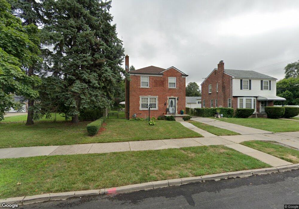
8214 Bingham St Detroit, MI 48228
Aviation NeighborhoodEstimated Value: $119,963 - $167,000
3
Beds
2
Baths
1,350
Sq Ft
$102/Sq Ft
Est. Value
About This Home
This home is located at 8214 Bingham St, Detroit, MI 48228 and is currently estimated at $138,241, approximately $102 per square foot. 8214 Bingham St is a home located in Wayne County with nearby schools including Barton Elementary School, Charles L. Spain Elementary-Middle School, and Edward 'Duke' Ellington Conservatory of Music and Art.
Ownership History
Date
Name
Owned For
Owner Type
Purchase Details
Closed on
Mar 24, 2015
Sold by
Capital Group Investments Llc
Bought by
First Alliance Investments Group Llc
Current Estimated Value
Purchase Details
Closed on
Feb 12, 2009
Sold by
Lowman Kenneth
Bought by
Capital Group Llc
Purchase Details
Closed on
Dec 5, 2007
Sold by
Jones Malcolm A and Jones Phyllis W
Bought by
Lowman Kenneth
Create a Home Valuation Report for This Property
The Home Valuation Report is an in-depth analysis detailing your home's value as well as a comparison with similar homes in the area
Home Values in the Area
Average Home Value in this Area
Purchase History
| Date | Buyer | Sale Price | Title Company |
|---|---|---|---|
| First Alliance Investments Group Llc | -- | None Available | |
| Capital Group Llc | -- | None Available | |
| Lowman Kenneth | -- | None Available |
Source: Public Records
Tax History Compared to Growth
Tax History
| Year | Tax Paid | Tax Assessment Tax Assessment Total Assessment is a certain percentage of the fair market value that is determined by local assessors to be the total taxable value of land and additions on the property. | Land | Improvement |
|---|---|---|---|---|
| 2025 | $1,602 | $51,000 | $0 | $0 |
| 2024 | $1,602 | $42,800 | $0 | $0 |
| 2023 | $1,556 | $33,500 | $0 | $0 |
| 2022 | $1,663 | $29,400 | $0 | $0 |
| 2021 | $1,616 | $22,100 | $0 | $0 |
| 2020 | $1,582 | $20,700 | $0 | $0 |
| 2019 | $1,590 | $15,600 | $0 | $0 |
| 2018 | $1,387 | $14,900 | $0 | $0 |
| 2017 | $283 | $14,900 | $0 | $0 |
| 2016 | $1,752 | $20,000 | $0 | $0 |
| 2015 | $2,000 | $20,000 | $0 | $0 |
| 2013 | $2,935 | $29,354 | $0 | $0 |
| 2010 | -- | $40,743 | $1,279 | $39,464 |
Source: Public Records
Map
Nearby Homes
- 8285 Cheyenne St
- 8207 Schaefer Hwy
- 13145 Mackenzie St
- 8229 Carlin St
- 7927 Bingham St
- 8537 Cheyenne St
- 12950 Mackenzie St
- 12953 Tireman Ave
- 7750 Morross Ct
- 8155 Appoline St
- 7813 Neckel St
- 7870 Oakman Blvd
- 7656 Neckel St
- 7857 Esper Blvd
- 7514 Calhoun St
- 5919 Oakman Blvd
- 7542 Neckel St
- 7741 Miller Rd
- 7658 Appoline St
- 8919 Steel St
- 8222 Bingham St
- 8204 Bingham St
- 8232 Bingham St
- 8203 Cheyenne St
- 8240 Bingham St
- 8223 Cheyenne St
- 8154 Bingham St
- 8237 Cheyenne St
- 8248 Bingham St
- 8247 Cheyenne St
- 8221 Bingham St
- 8201 Bingham St
- 8227 Bingham St
- 8159 Cheyenne St
- 8146 Bingham St
- 8256 Bingham St
- 8235 Bingham St
- 8253 Cheyenne St
- 8145 Cheyenne St
- 8145 Cheyenne St