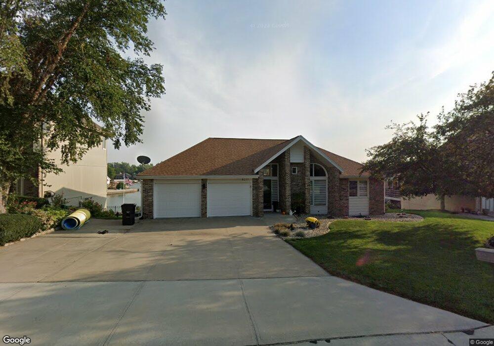
8217 Molokai Dr Papillion, NE 68046
Estimated Value: $528,000 - $643,000
2
Beds
2
Baths
1,500
Sq Ft
$384/Sq Ft
Est. Value
About This Home
This home is located at 8217 Molokai Dr, Papillion, NE 68046 and is currently estimated at $576,010, approximately $384 per square foot. 8217 Molokai Dr is a home located in Sarpy County with nearby schools including Platteview Central Junior High School and Platteview Senior High School.
Ownership History
Date
Name
Owned For
Owner Type
Purchase Details
Closed on
Dec 18, 2018
Sold by
Denker Judith L and Kirtell Lyle F
Bought by
Denker Julie A and Denker Clement Lee
Current Estimated Value
Home Financials for this Owner
Home Financials are based on the most recent Mortgage that was taken out on this home.
Original Mortgage
$180,000
Outstanding Balance
$114,963
Interest Rate
4.9%
Mortgage Type
New Conventional
Estimated Equity
$461,047
Create a Home Valuation Report for This Property
The Home Valuation Report is an in-depth analysis detailing your home's value as well as a comparison with similar homes in the area
Home Values in the Area
Average Home Value in this Area
Purchase History
| Date | Buyer | Sale Price | Title Company |
|---|---|---|---|
| Denker Julie A | $370,000 | Nebraska Title Co |
Source: Public Records
Mortgage History
| Date | Status | Borrower | Loan Amount |
|---|---|---|---|
| Open | Denker Julie A | $180,000 |
Source: Public Records
Tax History Compared to Growth
Tax History
| Year | Tax Paid | Tax Assessment Tax Assessment Total Assessment is a certain percentage of the fair market value that is determined by local assessors to be the total taxable value of land and additions on the property. | Land | Improvement |
|---|---|---|---|---|
| 2025 | $7,599 | $555,428 | $175,000 | $380,428 |
| 2024 | $8,661 | $531,165 | $172,000 | $359,165 |
| 2023 | $8,661 | $482,442 | $172,000 | $310,442 |
| 2022 | $8,299 | $435,795 | $120,000 | $315,795 |
| 2021 | $8,831 | $427,536 | $120,000 | $307,536 |
| 2020 | $7,976 | $368,153 | $96,000 | $272,153 |
| 2019 | $7,867 | $363,532 | $96,000 | $267,532 |
| 2018 | $3,446 | $362,764 | $96,000 | $266,764 |
| 2017 | $3,443 | $330,925 | $96,000 | $234,925 |
| 2016 | $4,178 | $316,298 | $96,000 | $220,298 |
| 2015 | $3,430 | $314,304 | $90,000 | $224,304 |
| 2014 | $3,883 | $309,747 | $90,000 | $219,747 |
| 2012 | -- | $309,906 | $90,000 | $219,906 |
Source: Public Records
Map
Nearby Homes
- 8609 Molokai Dr
- 8612 Makaha Cir
- 7912 Kona Cir
- 15560 S 79th Cir
- 19980 White Tail Ln
- 19910 White Tail Ln
- 8700 Raven Dr
- 6733 Platteview Rd
- TBD - 15600 S 63rd St
- 19577 Pheasant Ln
- 111 acres Platteview Rd
- 6711 Platteview Rd
- 7610 S 66th St
- 12715 S 79th St
- 12704 S 79th St
- 13002 S 66th Ave
- 12926 S 66th Ave
- 12930 S 66th Ave
- 12934 S 66th Ave
- 12620 S 78th Ave
- 8213 Molokai Dr
- 8303 Molokai Dr
- 0 Molokai Dr
- 7908 Molokai Dr
- 8209 Molokai Dr
- 8218 Molokai Dr
- 8214 Molokai Dr
- 8304 Molokai Dr
- 8311 Molokai Dr
- 8205 Molokai Dr
- 8308 Molokai Dr
- 8315 Molokai Dr
- 8201 Molokai Dr
- 8202 Molokai Dr
- 8312 Molokai Dr
- 8319 Molokai Dr
- 8119 Molokai Dr
- 8116 Molokai Dr
- 16503 Hilo Cir
- 8316 Molokai Dr