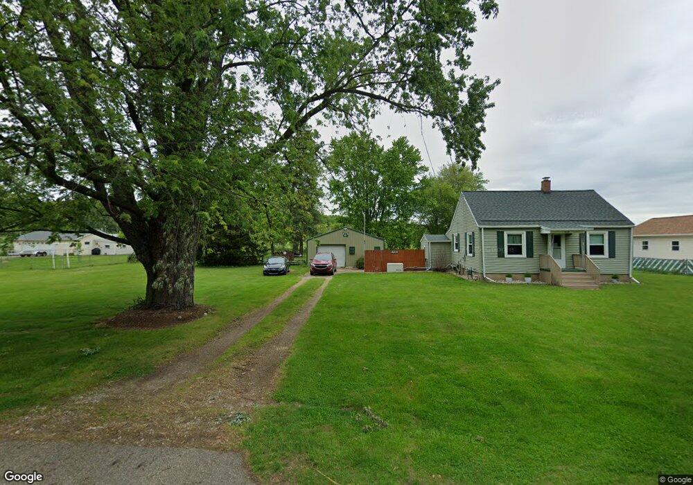
8219 Calvin Rd Battle Creek, MI 49017
Estimated Value: $117,000 - $157,000
2
Beds
1
Bath
672
Sq Ft
$208/Sq Ft
Est. Value
About This Home
This home is located at 8219 Calvin Rd, Battle Creek, MI 49017 and is currently estimated at $139,464, approximately $207 per square foot. 8219 Calvin Rd is a home located in Calhoun County with nearby schools including Pennfield Dunlap Elementary School, North Pennfield Elementary School, and Pennfield Middle School.
Ownership History
Date
Name
Owned For
Owner Type
Purchase Details
Closed on
Jan 9, 2023
Sold by
Lutz Cyrus W and Lutz Marilyn S
Bought by
Lutz Cyrus W and Lutz Cyrus W
Current Estimated Value
Purchase Details
Closed on
Nov 15, 2019
Sold by
Bennett Arthur J and Bennett Iris T
Bought by
Lutz Cyrus W and Lutz Marilyn S
Home Financials for this Owner
Home Financials are based on the most recent Mortgage that was taken out on this home.
Original Mortgage
$36,400
Interest Rate
3.6%
Mortgage Type
New Conventional
Purchase Details
Closed on
May 1, 2015
Sold by
Bennette Arthur and Bennett Ellen
Bought by
Lutz Cyrus W and Lutz Marilyn S
Create a Home Valuation Report for This Property
The Home Valuation Report is an in-depth analysis detailing your home's value as well as a comparison with similar homes in the area
Home Values in the Area
Average Home Value in this Area
Purchase History
| Date | Buyer | Sale Price | Title Company |
|---|---|---|---|
| Lutz Cyrus W | -- | -- | |
| Lutz Cyrus W | $60,000 | None Available | |
| Lutz Cyrus W | -- | None Available |
Source: Public Records
Mortgage History
| Date | Status | Borrower | Loan Amount |
|---|---|---|---|
| Previous Owner | Lutz Cyrus W | $36,400 |
Source: Public Records
Tax History Compared to Growth
Tax History
| Year | Tax Paid | Tax Assessment Tax Assessment Total Assessment is a certain percentage of the fair market value that is determined by local assessors to be the total taxable value of land and additions on the property. | Land | Improvement |
|---|---|---|---|---|
| 2025 | $1,836 | $59,400 | $0 | $0 |
| 2024 | $819 | $55,900 | $0 | $0 |
| 2023 | $1,332 | $47,610 | $0 | $0 |
| 2022 | $624 | $36,310 | $0 | $0 |
| 2021 | $1,337 | $34,980 | $0 | $0 |
| 2020 | $1,314 | $32,130 | $0 | $0 |
| 2019 | $1,271 | $31,740 | $0 | $0 |
| 2018 | $1,146 | $32,330 | $9,980 | $22,350 |
| 2017 | $0 | $30,340 | $0 | $0 |
| 2016 | $0 | $27,800 | $0 | $0 |
| 2015 | -- | $25,220 | $12,281 | $12,939 |
| 2014 | -- | $26,310 | $12,281 | $14,029 |
Source: Public Records
Map
Nearby Homes
- 114 Wanondoger Cir
- 220 Pennbrook Trail
- 150 Pennbrook Trail
- 21520 Swafford Rd
- V/L East Ave N
- 215 Pony Ave
- 22511 Capital Ave NE
- 6381 Saint Marys Lake Rd
- 22150 East Ave N
- 106 Buckingham
- 19687 East Ave N
- 146 Maplehurst Blvd
- 117 Old Lantern Trail
- 20259 Pine Lake Rd
- 9559 Brian Dr
- 1731 Capital Ave NE
- 8671 Gorsline Rd
- 228 Indian Rd
- 146 Indian Rd
- 20291 Chippewa Trail
- 8218 Calvin Rd
- 8210 Calvin Rd
- 81201 Calvin Rd
- 8223 Calvin Rd
- 8201 Calvin Rd
- 8226 Calvin Rd
- 8227 Calvin Rd
- 8200 Calvin Rd
- 8239 Calvin Rd
- 8245 Calvin Rd
- 8234 Calvin Rd
- 8195 Calvin Rd
- 8158 Calvin Rd
- 8250 Calvin Rd
- 8159 Calvin Rd
- 20936 Harding Rd
- 8259 Calvin Rd
- 8221 Swift Rd
- 8203 Swift Rd
- 20936 Harding Rd