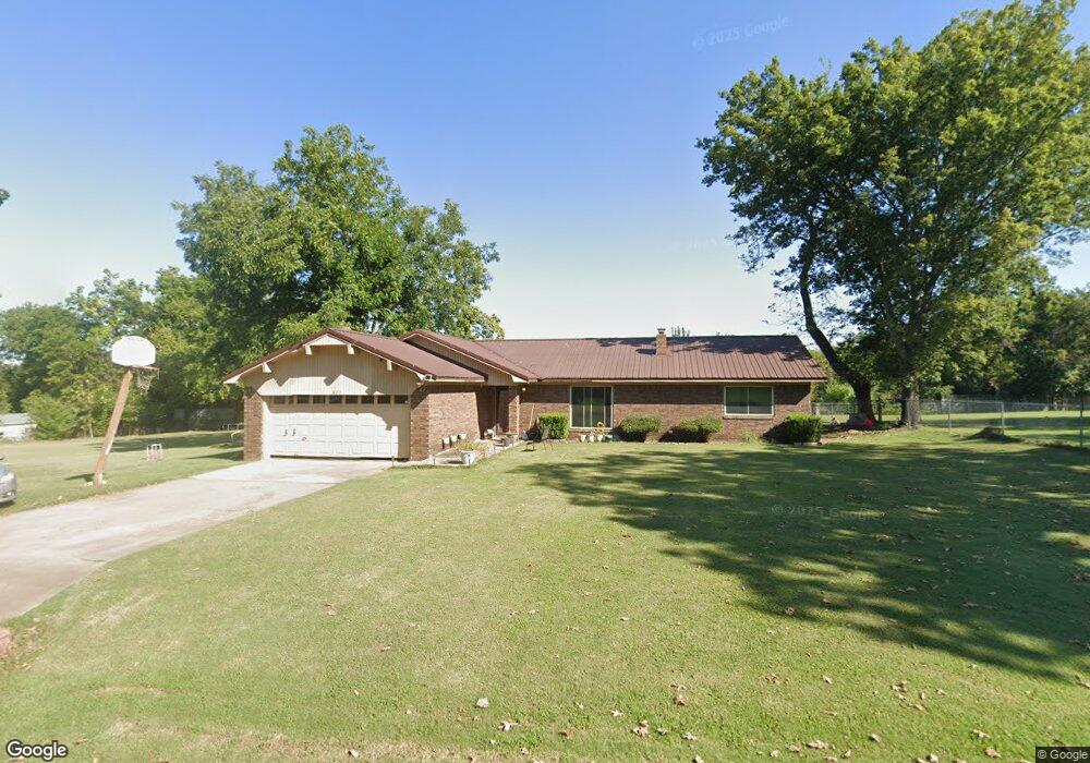
822 Cook Ave Arkoma, OK 74901
Estimated Value: $137,000 - $180,000
3
Beds
2
Baths
1,673
Sq Ft
$92/Sq Ft
Est. Value
About This Home
This home is located at 822 Cook Ave, Arkoma, OK 74901 and is currently estimated at $154,701, approximately $92 per square foot. 822 Cook Ave is a home located in Le Flore County with nearby schools including Singleton Elementary School, Arkoma High School, and The Montessori School of Fort Smith.
Ownership History
Date
Name
Owned For
Owner Type
Purchase Details
Closed on
Aug 23, 2016
Sold by
Young Paula and Young Timothy
Bought by
Cusick James D
Current Estimated Value
Home Financials for this Owner
Home Financials are based on the most recent Mortgage that was taken out on this home.
Original Mortgage
$102,827
Outstanding Balance
$81,885
Interest Rate
3.42%
Mortgage Type
New Conventional
Estimated Equity
$72,816
Purchase Details
Closed on
May 26, 2008
Sold by
Oliver Phillip G and Oliver Sandra
Bought by
Young Paula and Brand Pamela
Create a Home Valuation Report for This Property
The Home Valuation Report is an in-depth analysis detailing your home's value as well as a comparison with similar homes in the area
Purchase History
| Date | Buyer | Sale Price | Title Company |
|---|---|---|---|
| Cusick James D | $100,000 | None Available | |
| Young Paula | -- | None Available |
Source: Public Records
Mortgage History
| Date | Status | Borrower | Loan Amount |
|---|---|---|---|
| Open | Cusick James D | $102,827 |
Source: Public Records
Tax History
| Year | Tax Paid | Tax Assessment Tax Assessment Total Assessment is a certain percentage of the fair market value that is determined by local assessors to be the total taxable value of land and additions on the property. | Land | Improvement |
|---|---|---|---|---|
| 2025 | $756 | $10,759 | $770 | $9,989 |
| 2024 | $732 | $10,759 | $752 | $10,007 |
| 2023 | $732 | $10,142 | $743 | $9,399 |
| 2022 | $709 | $10,142 | $743 | $9,399 |
| 2021 | $709 | $10,142 | $743 | $9,399 |
| 2020 | $720 | $10,282 | $743 | $9,539 |
| 2019 | $727 | $10,373 | $743 | $9,630 |
| 2018 | $756 | $10,754 | $743 | $10,011 |
| 2017 | $778 | $11,032 | $743 | $10,289 |
| 2016 | $652 | $8,416 | $556 | $7,860 |
| 2015 | $545 | $8,015 | $515 | $7,500 |
| 2014 | $529 | $7,782 | $486 | $7,296 |
Source: Public Records
Map
Nearby Homes
- TBD Yoakum Ave
- 745 Yoakum Ave
- 107 Oak St
- 301 Choctaw St
- 3706 Towson Ave
- 1505 Jackson Ct
- 523 S 14th St
- 1706 Independence St
- 1603 Dallas St
- 1700 S Carthage St
- 4808 S 16th Terrace
- 3215 S 18th St
- 1604 Savannah Dr
- 1600 S 11th St
- 1400 S 11th St
- 1404 S 11th St
- 2910, 2912 S 16th St
- 3821 Old Jenny Lind Rd
- TBD Mockingbird Ln
- 1901 S Y St
- 820 Cook Ave
- 1427 Highway 9a
- 1427 Oklahoma 9a
- 5145 E 5th St
- 833 Highway 9a
- 844 Cook Ave
- 1404 Main St
- 835 Cook Ave
- 835 Cook Ave
- 905 Highway 9a
- 835 Highway 9a
- 900 Cook Ave
- 0 Hwy 112 Hwy Unit 1533133
- 0 Hwy 112 Hwy Unit 1612267
- 901 Cook Ave
- 905 Oklahoma 9a
- 805 Highway 9a
- 725 Cook Ave
- 806 Highway 9a
- 715 Cook Ave
Your Personal Tour Guide
Ask me questions while you tour the home.