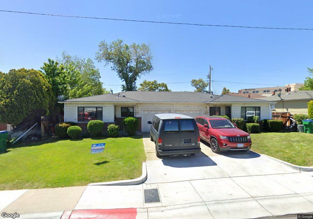
822 E Taylor St Reno, NV 89502
Wells Avenue District NeighborhoodEstimated Value: $533,159 - $667,000
4
Beds
2
Baths
1,654
Sq Ft
$367/Sq Ft
Est. Value
About This Home
This home is located at 822 E Taylor St, Reno, NV 89502 and is currently estimated at $606,290, approximately $366 per square foot. 822 E Taylor St is a home located in Washoe County with nearby schools including Veterans Memorial Elementary School, Vaughn Middle School, and Earl Wooster High School.
Ownership History
Date
Name
Owned For
Owner Type
Purchase Details
Closed on
Apr 16, 2020
Sold by
Eq3 Llc
Bought by
Manguray John M and Manguray Kimberley L
Current Estimated Value
Home Financials for this Owner
Home Financials are based on the most recent Mortgage that was taken out on this home.
Original Mortgage
$175,000
Interest Rate
3.1%
Mortgage Type
New Conventional
Purchase Details
Closed on
Sep 16, 2016
Sold by
Mocho Mike
Bought by
Eq3 Llc
Create a Home Valuation Report for This Property
The Home Valuation Report is an in-depth analysis detailing your home's value as well as a comparison with similar homes in the area
Home Values in the Area
Average Home Value in this Area
Purchase History
| Date | Buyer | Sale Price | Title Company |
|---|---|---|---|
| Manguray John M | $430,000 | Ticor Title Reno | |
| Eq3 Llc | $275,000 | Capital Title Co Of Ne |
Source: Public Records
Mortgage History
| Date | Status | Borrower | Loan Amount |
|---|---|---|---|
| Previous Owner | Manguray John M | $175,000 |
Source: Public Records
Tax History
| Year | Tax Paid | Tax Assessment Tax Assessment Total Assessment is a certain percentage of the fair market value that is determined by local assessors to be the total taxable value of land and additions on the property. | Land | Improvement |
|---|---|---|---|---|
| 2026 | $943 | $76,845 | $55,195 | $21,650 |
| 2024 | $1,187 | $76,689 | $55,195 | $21,494 |
| 2023 | $1,100 | $76,041 | $57,505 | $18,536 |
| 2022 | $1,020 | $61,374 | $45,675 | $15,699 |
| 2021 | $946 | $46,865 | $31,465 | $15,400 |
| 2020 | $888 | $42,142 | $26,950 | $15,192 |
| 2019 | $846 | $40,196 | $25,690 | $14,506 |
| 2018 | $807 | $30,316 | $16,450 | $13,866 |
| 2017 | $756 | $29,965 | $16,450 | $13,515 |
| 2016 | $756 | $27,868 | $14,420 | $13,448 |
| 2015 | $755 | $23,942 | $10,430 | $13,512 |
| 2014 | $731 | $21,753 | $9,100 | $12,653 |
| 2013 | -- | $19,065 | $7,000 | $12,065 |
Source: Public Records
Map
Nearby Homes
- 939 Bates Ave
- 755 Balzar Cir
- 943 S Wells Ave
- 825 Cordone Ave
- 243 Claremont St
- 1339 Locust St
- 446 Roberts St
- 880 S Center St
- 831 Ryland St
- 800 S Center St
- 330 Stewart St
- 537 Colorado River Blvd
- 536 Sinclair St
- 60 Caliente St
- 101 S Wells Ave
- 621 Forest St
- 627 E 2nd St
- 343 & 347 Mount Rose St St
- 343 Mount Rose St
- 512 Humboldt St
- 800 E Taylor St
- 820 E Taylor St
- 825 Belli Dr
- 827 Belli Dr
- 804 E Taylor St
- 850 E Taylor St
- 845 Belli Dr
- 845 Belli Dr Unit 6
- 845 Belli Dr Unit 5
- 765 Belli Dr
- 770 E Taylor St
- 860 E Taylor St
- 825 E Taylor St Unit 825 Taylor
- 825 E Taylor St
- 805 E Taylor St
- 865 Belli Dr
- 740 E Taylor St
- 882 Edelweiss St
- 875 Helvetia Ave
- 880 E Taylor St
Your Personal Tour Guide
Ask me questions while you tour the home.