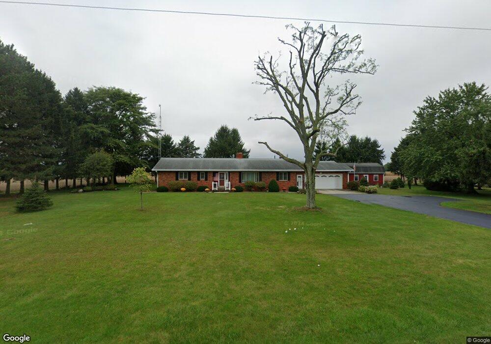
8240 State Highway 53 N Upper Sandusky, OH 43351
Estimated Value: $262,000 - $367,000
3
Beds
3
Baths
2,145
Sq Ft
$147/Sq Ft
Est. Value
About This Home
This home is located at 8240 State Highway 53 N, Upper Sandusky, OH 43351 and is currently estimated at $314,251, approximately $146 per square foot. 8240 State Highway 53 N is a home with nearby schools including Upper Sandusky High School and St. Peter Elementary School.
Ownership History
Date
Name
Owned For
Owner Type
Purchase Details
Closed on
Jun 11, 2013
Sold by
Merrick Erika
Bought by
Anderson Patricia and Eriak Merrick Irrevocable Trust
Current Estimated Value
Purchase Details
Closed on
Apr 30, 2013
Sold by
Merrick Erika and Merrick Lawrence G
Bought by
Merrick Erika
Purchase Details
Closed on
Jun 9, 2009
Sold by
Merrick Lawrence G and Merrick Erika
Bought by
Merrick Erika and Merrick Lawrence G
Create a Home Valuation Report for This Property
The Home Valuation Report is an in-depth analysis detailing your home's value as well as a comparison with similar homes in the area
Home Values in the Area
Average Home Value in this Area
Purchase History
| Date | Buyer | Sale Price | Title Company |
|---|---|---|---|
| Anderson Patricia | -- | None Available | |
| Merrick Erika | -- | None Available | |
| Merrick Erika | -- | None Available |
Source: Public Records
Tax History Compared to Growth
Tax History
| Year | Tax Paid | Tax Assessment Tax Assessment Total Assessment is a certain percentage of the fair market value that is determined by local assessors to be the total taxable value of land and additions on the property. | Land | Improvement |
|---|---|---|---|---|
| 2024 | $2,123 | $78,900 | $4,770 | $74,130 |
| 2023 | $2,123 | $78,900 | $4,770 | $74,130 |
| 2022 | $2,157 | $64,410 | $3,880 | $60,530 |
| 2021 | $1,791 | $64,410 | $3,880 | $60,530 |
| 2020 | $1,791 | $64,410 | $3,880 | $60,530 |
| 2019 | $1,790 | $64,410 | $3,880 | $60,530 |
| 2018 | $1,619 | $60,190 | $3,380 | $56,810 |
| 2017 | $1,646 | $60,190 | $3,380 | $56,810 |
| 2016 | -- | $60,190 | $3,380 | $56,810 |
| 2015 | -- | $57,490 | $3,380 | $54,110 |
| 2014 | -- | $57,490 | $3,380 | $54,110 |
| 2013 | -- | $57,490 | $3,380 | $54,110 |
Source: Public Records
Map
Nearby Homes
- 0 State Route 53 & 67 Unit 11165687
- 987 Greenbrier Rd Unit 101
- 7160 County Highway 47
- 955 Greenbrier Rd
- 900 Kimmel Ct
- 903 N Warpole St
- 606 Polaris Dr
- 620 Mission Dr
- 585 Betty Lou St
- 487 N 4th St
- 123 Rivers Edge Ln
- 453 N 7th St
- 443 N 7th St
- 435 Front St
- 417 N 8th St
- 222 E Bigelow St
- 109 Rivers Edge Ln Unit C
- 212 Duck Pond Rd
- 334 N 4th St
- 326 N 5th St
- 8210 State Highway 53 N
- 8381 State Highway 53 N
- 8895 County Highway 44
- 8315 County Highway 44
- 8956 County Highway 44
- 8836 County Highway 44
- 8283 County Highway 44
- 9157 County Highway 44
- 7685 State Highway 53 N
- 8911 State Highway 53 N
- 7619 Ohio 53
- 9249 County Highway 44
- 8946 State Highway 53 N
- 7739 County Highway 112
- 8988 State Highway 53 N
- 8470 State Highway 67
- 9344 County Highway 44
- 7848 County Highway 112
- 7492 Ohio 53
- 7914 County Highway 44