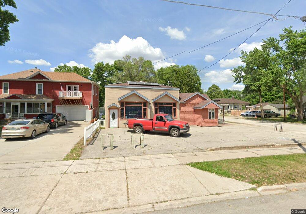
826 E State St Mason City, IA 50401
--
Bed
--
Bath
939
Sq Ft
3,877
Sq Ft Lot
About This Home
This home is located at 826 E State St, Mason City, IA 50401. 826 E State St is a home located in Cerro Gordo County with nearby schools including Mason City High School, North Iowa Christian School, and Mason City Seventh Day Adventi.
Ownership History
Date
Name
Owned For
Owner Type
Purchase Details
Closed on
Mar 18, 2008
Sold by
Link Station L L C
Bought by
Johnson Graves Real Estate Llc
Home Financials for this Owner
Home Financials are based on the most recent Mortgage that was taken out on this home.
Original Mortgage
$60,000
Outstanding Balance
$37,379
Interest Rate
5.74%
Mortgage Type
Future Advance Clause Open End Mortgage
Create a Home Valuation Report for This Property
The Home Valuation Report is an in-depth analysis detailing your home's value as well as a comparison with similar homes in the area
Home Values in the Area
Average Home Value in this Area
Purchase History
| Date | Buyer | Sale Price | Title Company |
|---|---|---|---|
| Johnson Graves Real Estate Llc | -- | None Available | |
| Johnson Graves Real Estate Llc | $25,500 | None Available |
Source: Public Records
Mortgage History
| Date | Status | Borrower | Loan Amount |
|---|---|---|---|
| Open | Johnson Graves Real Estate Llc | $60,000 |
Source: Public Records
Tax History Compared to Growth
Tax History
| Year | Tax Paid | Tax Assessment Tax Assessment Total Assessment is a certain percentage of the fair market value that is determined by local assessors to be the total taxable value of land and additions on the property. | Land | Improvement |
|---|---|---|---|---|
| 2024 | $922 | $57,600 | $10,120 | $47,480 |
| 2023 | $1,016 | $57,600 | $10,120 | $47,480 |
| 2022 | $1,044 | $51,360 | $7,790 | $43,570 |
| 2021 | $1,098 | $50,690 | $7,790 | $42,900 |
| 2020 | $1,753 | $50,690 | $7,790 | $42,900 |
| 2019 | $1,030 | $0 | $0 | $0 |
| 2018 | $1,008 | $0 | $0 | $0 |
| 2017 | $888 | $0 | $0 | $0 |
| 2016 | $704 | $0 | $0 | $0 |
| 2015 | $704 | $0 | $0 | $0 |
| 2014 | $698 | $0 | $0 | $0 |
| 2013 | $672 | $0 | $0 | $0 |
Source: Public Records
Map
Nearby Homes
- 102 S York Ave
- 29 S Vermont Ave
- 112 S Vermont Ave
- 201 S Vermont Ave
- 682 3rd St NE
- 680 3rd St NE
- 834 4th St SE
- 5 Willow Dr
- 636 2nd St NE
- 634 3rd St SE
- 35 S Tennessee Ave
- 1044 Maple Dr
- 316 S Kentucky Ave
- 659 3rd Place SE
- 341 S Carolina Ave
- 413 S Carolina Ave
- 706 6th Place SE
- 212 S Ohio Ave
- 102 S Connecticut Ave Unit A-E
- 415 N Massachusetts Ave
- 10 N York Ave
- 818 E State St
- 12 N York Ave
- 836 E State St
- 812 E State St
- 13 N York Ave
- 823 E State St
- 819 E State St
- 840 E State St
- 808 E State St
- 835 E State St
- 809 E State St
- 803 E State St
- 843 E State St
- 11 S Virginia Ave
- 20 S York Ave
- 17 S York Ave
- 845 E State St
- 13 S Virginia Ave
- 711 E State St