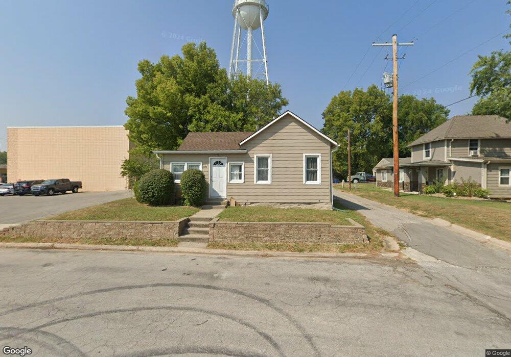
8260 Wea St De Soto, KS 66018
Estimated Value: $209,951 - $262,000
2
Beds
2
Baths
1,066
Sq Ft
$217/Sq Ft
Est. Value
About This Home
This home is located at 8260 Wea St, De Soto, KS 66018 and is currently estimated at $230,988, approximately $216 per square foot. 8260 Wea St is a home located in Johnson County with nearby schools including Starside Elementary School, Lexington Trails Middle School, and De Soto High School.
Ownership History
Date
Name
Owned For
Owner Type
Purchase Details
Closed on
Apr 26, 2019
Sold by
Market Street Property Llc
Bought by
Jc Management Group Llc
Current Estimated Value
Purchase Details
Closed on
Apr 13, 2018
Sold by
Kreutzer Mark A and Kreutzer Pamela A
Bought by
Market Street Property Llc
Purchase Details
Closed on
Sep 20, 2004
Sold by
Djl Properties Llc
Bought by
Kreutzer Mark A and Kreutzer Pamela A
Home Financials for this Owner
Home Financials are based on the most recent Mortgage that was taken out on this home.
Original Mortgage
$42,000
Interest Rate
5.81%
Mortgage Type
Purchase Money Mortgage
Create a Home Valuation Report for This Property
The Home Valuation Report is an in-depth analysis detailing your home's value as well as a comparison with similar homes in the area
Home Values in the Area
Average Home Value in this Area
Purchase History
| Date | Buyer | Sale Price | Title Company |
|---|---|---|---|
| Jc Management Group Llc | -- | Alpha Title Guaranty Inc | |
| Market Street Property Llc | -- | Platinum Title Llc | |
| Kreutzer Mark A | -- | Chicago Title Insurance Comp |
Source: Public Records
Mortgage History
| Date | Status | Borrower | Loan Amount |
|---|---|---|---|
| Previous Owner | Kreutzer Mark A | $42,000 |
Source: Public Records
Tax History Compared to Growth
Tax History
| Year | Tax Paid | Tax Assessment Tax Assessment Total Assessment is a certain percentage of the fair market value that is determined by local assessors to be the total taxable value of land and additions on the property. | Land | Improvement |
|---|---|---|---|---|
| 2024 | $2,178 | $18,067 | $4,461 | $13,606 |
| 2023 | $1,960 | $15,272 | $3,718 | $11,554 |
| 2022 | $2,066 | $15,778 | $2,974 | $12,804 |
| 2021 | $1,768 | $12,926 | $2,467 | $10,459 |
| 2020 | $1,558 | $11,144 | $2,245 | $8,899 |
| 2019 | $1,823 | $12,892 | $2,130 | $10,762 |
| 2018 | $1,564 | $10,971 | $2,130 | $8,841 |
| 2017 | $1,392 | $9,488 | $2,130 | $7,358 |
| 2016 | $1,042 | $7,027 | $2,130 | $4,897 |
| 2015 | $965 | $6,624 | $2,130 | $4,494 |
| 2013 | -- | $7,005 | $2,130 | $4,875 |
Source: Public Records
Map
Nearby Homes
- 8220 Wyandotte St
- 8440 Wea St
- 32845 W 84th St
- 8375 Wyandotte St
- 33321 Lexington Ave
- 8600 Willow Ln
- 8525 Penner Ave
- 8675 Shorewood Dr
- 8355 Kill Creek Rd
- 8844 Golden Ln
- 8315 Primrose St
- 31714 W 83rd Place
- 8459 Primrose St
- 29655 W 83rd St
- 32225 W 88th St
- 8464 Valley Spring Dr
- 34571 W 83rd St
- The Andrew Plan at Arbor Ridge
- The Addison Plan at Arbor Ridge
- The Ash Plan at Arbor Ridge