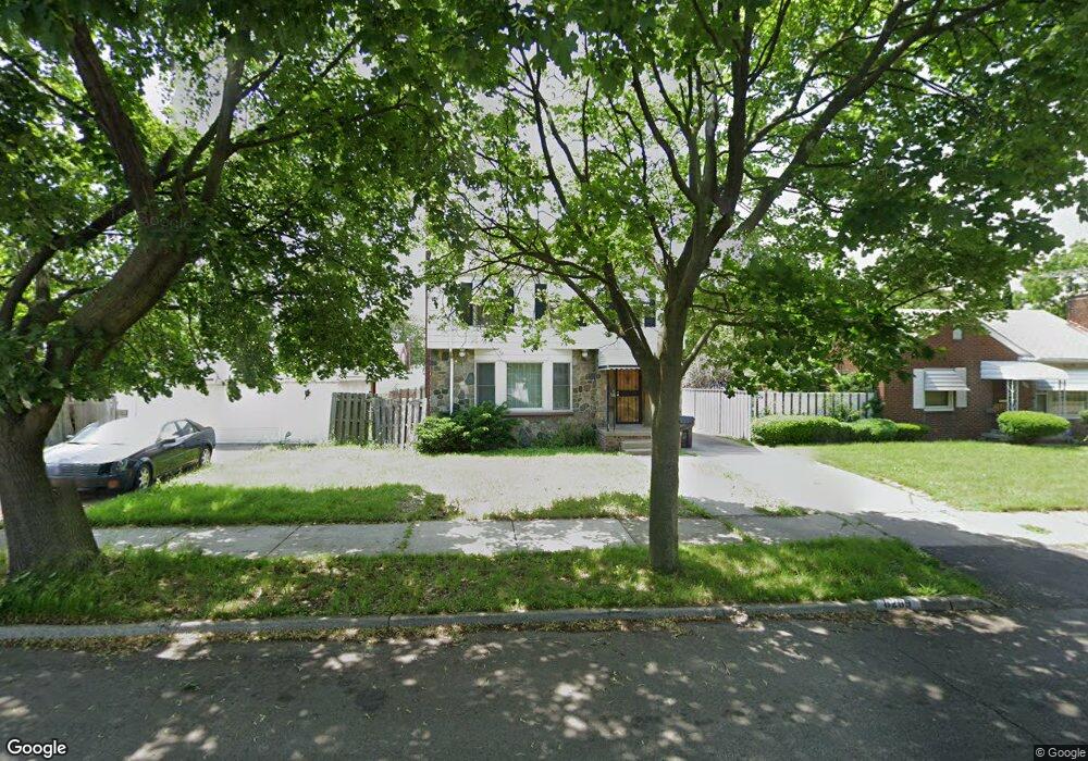
8269 Ward St Detroit, MI 48228
Aviation NeighborhoodEstimated Value: $121,510 - $184,000
--
Bed
2
Baths
1,661
Sq Ft
$92/Sq Ft
Est. Value
About This Home
This home is located at 8269 Ward St, Detroit, MI 48228 and is currently estimated at $152,128, approximately $91 per square foot. 8269 Ward St is a home located in Wayne County with nearby schools including Barton Elementary School, Charles L. Spain Elementary-Middle School, and Edward 'Duke' Ellington Conservatory of Music and Art.
Ownership History
Date
Name
Owned For
Owner Type
Purchase Details
Closed on
Jan 12, 2012
Sold by
Armstead Renee C
Bought by
Detroit Edison Credit Union and Lake Trust Credit Union
Current Estimated Value
Purchase Details
Closed on
Sep 21, 2005
Sold by
Scott Derrick L and Scott Regina D
Bought by
Armstead Renee C
Home Financials for this Owner
Home Financials are based on the most recent Mortgage that was taken out on this home.
Original Mortgage
$146,760
Interest Rate
5.88%
Mortgage Type
Fannie Mae Freddie Mac
Create a Home Valuation Report for This Property
The Home Valuation Report is an in-depth analysis detailing your home's value as well as a comparison with similar homes in the area
Home Values in the Area
Average Home Value in this Area
Purchase History
| Date | Buyer | Sale Price | Title Company |
|---|---|---|---|
| Detroit Edison Credit Union | $27,260 | None Available | |
| Armstead Renee C | $151,300 | Land Owners Title Agency |
Source: Public Records
Mortgage History
| Date | Status | Borrower | Loan Amount |
|---|---|---|---|
| Previous Owner | Armstead Renee C | $146,760 |
Source: Public Records
Tax History Compared to Growth
Tax History
| Year | Tax Paid | Tax Assessment Tax Assessment Total Assessment is a certain percentage of the fair market value that is determined by local assessors to be the total taxable value of land and additions on the property. | Land | Improvement |
|---|---|---|---|---|
| 2025 | $1,548 | $54,700 | $0 | $0 |
| 2024 | $1,548 | $46,000 | $0 | $0 |
| 2023 | $1,263 | $36,000 | $0 | $0 |
| 2022 | $1,606 | $29,500 | $0 | $0 |
| 2021 | $1,321 | $22,100 | $0 | $0 |
| 2020 | $1,560 | $20,700 | $0 | $0 |
| 2019 | $1,536 | $15,900 | $0 | $0 |
| 2018 | $1,341 | $14,300 | $0 | $0 |
| 2017 | $271 | $14,300 | $0 | $0 |
| 2016 | $2,222 | $38,200 | $0 | $0 |
| 2015 | $2,221 | $38,200 | $0 | $0 |
| 2013 | $118 | $1,180 | $0 | $0 |
| 2010 | -- | $1,180 | $1,179 | $1 |
Source: Public Records
Map
Nearby Homes
- 8285 Cheyenne St
- 13145 Mackenzie St
- 8537 Cheyenne St
- 12950 Mackenzie St
- 8207 Schaefer Hwy
- 8155 Appoline St
- 8229 Carlin St
- 7927 Bingham St
- 12953 Tireman Ave
- 7870 Oakman Blvd
- 7750 Morross Ct
- 5919 Oakman Blvd
- 8919 Steel St
- 7813 Neckel St
- 7857 Esper Blvd
- 8833 Manor St
- 7741 Miller Rd
- 7656 Neckel St
- 7658 Appoline St
- 8869 Manor St
- 8269 Ward St
- 8257 Ward St
- 8281 Ward St
- 8247 Ward St
- 8270 Cheyenne St
- 8260 Cheyenne St
- 8256 Cheyenne St
- 8260 Ward St
- 8411 Littlefield St
- 8286 Cheyenne St
- 8246 Cheyenne St
- 8233 Ward St
- 8294 Cheyenne St
- 8238 Cheyenne St
- 8301 Littlefield St
- 8295 Littlefield St
- 8227 Ward St
- 8300 Cheyenne St
- 8230 Cheyenne St
- 8221 Ward St