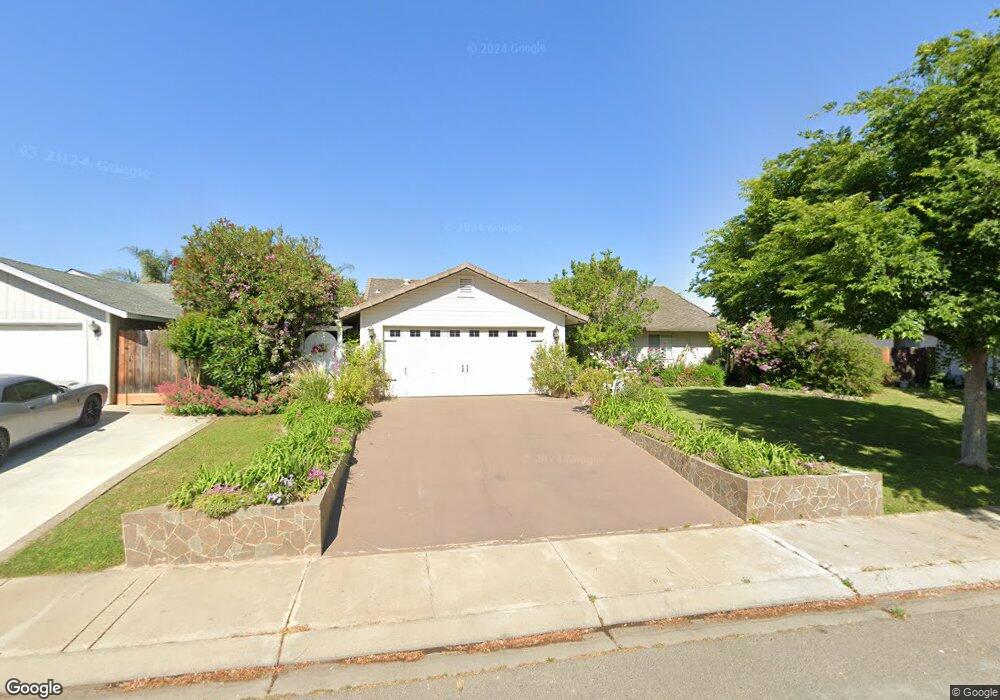
827 Massasso St Merced, CA 95341
Estimated Value: $362,188 - $410,000
4
Beds
2
Baths
1,614
Sq Ft
$237/Sq Ft
Est. Value
About This Home
This home is located at 827 Massasso St, Merced, CA 95341 and is currently estimated at $382,047, approximately $236 per square foot. 827 Massasso St is a home located in Merced County with nearby schools including Leontine Gracey Elementary School, Tenaya Middle School, and El Capitan High School.
Ownership History
Date
Name
Owned For
Owner Type
Purchase Details
Closed on
Nov 14, 2024
Sold by
Lopez Delia
Bought by
Delia C Lopez Trust and Lopez
Current Estimated Value
Purchase Details
Closed on
Apr 9, 1997
Sold by
Va
Bought by
Lopez Delia
Home Financials for this Owner
Home Financials are based on the most recent Mortgage that was taken out on this home.
Original Mortgage
$46,500
Interest Rate
7.86%
Mortgage Type
Seller Take Back
Purchase Details
Closed on
Jan 13, 1997
Sold by
Ge Capital Mtg Services Inc
Bought by
Va
Create a Home Valuation Report for This Property
The Home Valuation Report is an in-depth analysis detailing your home's value as well as a comparison with similar homes in the area
Purchase History
| Date | Buyer | Sale Price | Title Company |
|---|---|---|---|
| Delia C Lopez Trust | -- | None Listed On Document | |
| Lopez Delia | -- | -- | |
| Va | -- | Fidelity National Title |
Source: Public Records
Mortgage History
| Date | Status | Borrower | Loan Amount |
|---|---|---|---|
| Previous Owner | Lopez Delia | $46,500 |
Source: Public Records
Tax History
| Year | Tax Paid | Tax Assessment Tax Assessment Total Assessment is a certain percentage of the fair market value that is determined by local assessors to be the total taxable value of land and additions on the property. | Land | Improvement |
|---|---|---|---|---|
| 2025 | $1,455 | $140,854 | $40,703 | $100,151 |
| 2024 | $1,455 | $138,093 | $39,905 | $98,188 |
| 2023 | $1,434 | $135,386 | $39,123 | $96,263 |
| 2022 | $1,410 | $132,732 | $38,356 | $94,376 |
| 2021 | $1,413 | $130,130 | $37,604 | $92,526 |
| 2020 | $1,421 | $128,797 | $37,219 | $91,578 |
| 2019 | $1,398 | $126,273 | $36,490 | $89,783 |
| 2018 | $1,276 | $123,798 | $35,775 | $88,023 |
| 2017 | $1,297 | $121,372 | $35,074 | $86,298 |
| 2016 | $1,276 | $118,993 | $34,387 | $84,606 |
| 2015 | $1,255 | $117,207 | $33,871 | $83,336 |
| 2014 | $1,227 | $114,912 | $33,208 | $81,704 |
Source: Public Records
Map
Nearby Homes
- 2051 Wardrobe Ave
- 980 Sydney Ln
- 2044 W State Highway 140
- 1803 Lopes Ave
- 965 N Bryant
- 817 T St
- 1251 W 9th St
- 1220 Fig Ave
- 915 R St
- 1656 W North Bear Creek Dr Unit 9
- 1664 W North Bear Creek Dr Unit 5
- 1646 W North Bear Creek Dr
- 296 Grand Canyon Ct
- 1648 W North Bear Creek Dr
- 835 W 10th St
- 2500 N State Highway 59 Unit 36
- 2500 N State Highway 59 Unit 278
- 2500 N State Highway 59 Unit 239
- 2500 N State Highway 59 Unit 18
- 2500 N State Highway 59
- 849 Massasso St
- 793 Massasso St
- 871 Massasso St
- 771 Massasso St
- 826 Massasso St
- 792 Massasso St
- 848 Massasso St
- 749 Massasso St
- 893 Massasso St
- 770 Massasso St
- 870 Massasso St
- 748 Massasso St
- 862 Beechcraft Ave
- 727 Massasso St
- 892 Massasso St
- 791 Marian Ct
- 825 Marian Ct
- 769 Marian Ct
- 847 Marian Ct
- 747 Marian Ct
Your Personal Tour Guide
Ask me questions while you tour the home.