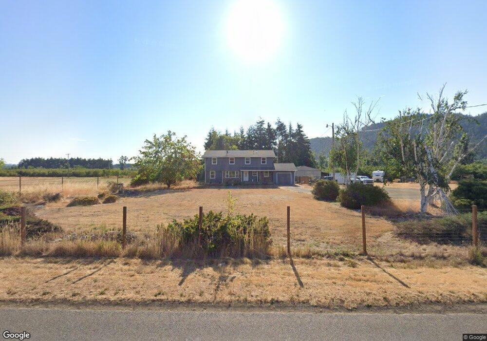
82735 Sears Rd Creswell, OR 97426
Estimated Value: $534,000 - $657,516
4
Beds
3
Baths
1,654
Sq Ft
$361/Sq Ft
Est. Value
About This Home
This home is located at 82735 Sears Rd, Creswell, OR 97426 and is currently estimated at $596,379, approximately $360 per square foot. 82735 Sears Rd is a home located in Lane County with nearby schools including Creslane Elementary School, Creswell Middle School, and Creswell High School.
Ownership History
Date
Name
Owned For
Owner Type
Purchase Details
Closed on
Jul 20, 2016
Sold by
Hansen Donald E and Hansen Terri D
Bought by
Towns Curtis L and Towns Tiffany L
Current Estimated Value
Home Financials for this Owner
Home Financials are based on the most recent Mortgage that was taken out on this home.
Original Mortgage
$299,250
Outstanding Balance
$238,583
Interest Rate
3.54%
Mortgage Type
New Conventional
Estimated Equity
$357,796
Purchase Details
Closed on
Apr 9, 2009
Sold by
Bartel Royce M and Bartel Mary E
Bought by
Hansen Donald E and Hansen Terri D
Home Financials for this Owner
Home Financials are based on the most recent Mortgage that was taken out on this home.
Original Mortgage
$220,000
Interest Rate
5.06%
Mortgage Type
Unknown
Create a Home Valuation Report for This Property
The Home Valuation Report is an in-depth analysis detailing your home's value as well as a comparison with similar homes in the area
Home Values in the Area
Average Home Value in this Area
Purchase History
| Date | Buyer | Sale Price | Title Company |
|---|---|---|---|
| Towns Curtis L | $315,000 | First American Title | |
| Hansen Donald E | -- | Cascade Title Co |
Source: Public Records
Mortgage History
| Date | Status | Borrower | Loan Amount |
|---|---|---|---|
| Open | Towns Curtis L | $299,250 | |
| Previous Owner | Hansen Donald E | $220,000 |
Source: Public Records
Tax History Compared to Growth
Tax History
| Year | Tax Paid | Tax Assessment Tax Assessment Total Assessment is a certain percentage of the fair market value that is determined by local assessors to be the total taxable value of land and additions on the property. | Land | Improvement |
|---|---|---|---|---|
| 2024 | $3,205 | $314,686 | -- | -- |
| 2023 | $3,205 | $305,521 | $0 | $0 |
| 2022 | $3,240 | $269,496 | $0 | $0 |
| 2021 | $2,975 | $248,471 | $0 | $0 |
| 2020 | $2,944 | $241,234 | $0 | $0 |
| 2019 | $2,885 | $234,208 | $0 | $0 |
| 2018 | $2,856 | $220,764 | $0 | $0 |
| 2017 | $2,705 | $220,764 | $0 | $0 |
| 2016 | $2,802 | $214,334 | $0 | $0 |
| 2015 | $2,697 | $208,091 | $0 | $0 |
| 2014 | $2,686 | $202,030 | $0 | $0 |
Source: Public Records
Map
Nearby Homes
- 0 River Dr
- 82682 River Dr
- 83062 Dale Kuni Rd
- 316 Sunday Dr
- 336 Sunday Dr
- 375 Sunday Dr
- 375 Magnolia Dr
- 491 Ironwood Loop
- 685 St Andrews Loop
- 400 N Mill St Unit 1
- 700 N Mill St Unit 56
- 700 N Mill St Unit 109
- 700 N Mill St
- 0 Holbrook Ln Unit 339588620
- 82277 Davisson Rd
- 589 Mary Neal Ln
- 689 Blue Jay Loop
- 156 N 1st St
- 83354 N Pacific Hwy
- 1 Queens Ave Unit 1
- 82653 Sears Rd
- 82755 Sears Rd
- 82800 River Dr
- 82675 Sears Rd
- 82565 Sears Rd
- 0000 Undisclosed Way
- 0 Undisclosed Way Unit 599433
- 82950 Horsebarn Way
- 0 Undisclosed Way Unit 8069806
- 82545 River Dr
- 34184 E Cloverdale Rd
- 82950 River Dr
- 82540 River Dr
- 34223 E Cloverdale Rd
- 34162 E Cloverdale Rd
- 82869 Brookhurst St
- 82515 N River Dr
- 34124 E Cloverdale Rd
- 82875 Brookhurst St
- 82883 Brookhurst St