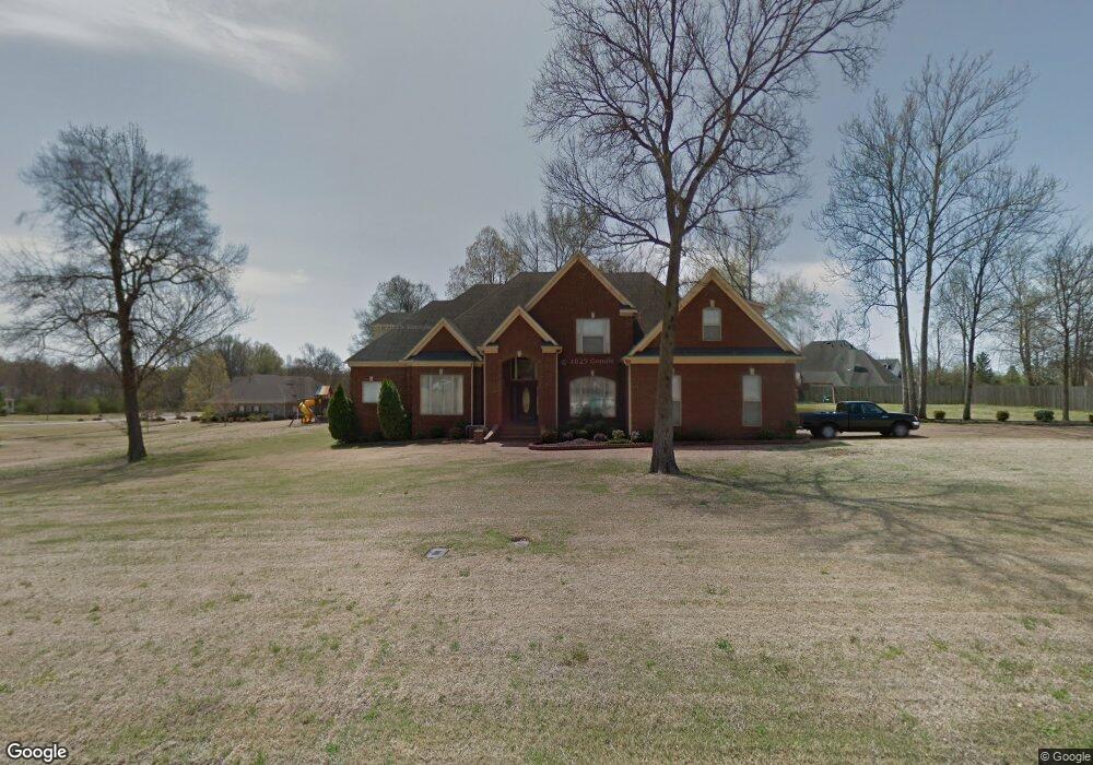
8279 Kings Crossing Dr Olive Branch, MS 38654
Estimated Value: $347,000 - $476,994
4
Beds
4
Baths
3,550
Sq Ft
$122/Sq Ft
Est. Value
About This Home
This home is located at 8279 Kings Crossing Dr, Olive Branch, MS 38654 and is currently estimated at $434,749, approximately $122 per square foot. 8279 Kings Crossing Dr is a home located in DeSoto County with nearby schools including Olive Branch Elementary School, Chickasaw Elementary School, and Olive Branch Middle School.
Ownership History
Date
Name
Owned For
Owner Type
Purchase Details
Closed on
Nov 13, 2009
Sold by
Thomas Gray Mattie and Gray Ronald Allen
Bought by
Freeman Ronnie L and Freeman Kincharska N
Current Estimated Value
Home Financials for this Owner
Home Financials are based on the most recent Mortgage that was taken out on this home.
Original Mortgage
$274,928
Outstanding Balance
$176,769
Interest Rate
4.94%
Mortgage Type
FHA
Estimated Equity
$257,980
Create a Home Valuation Report for This Property
The Home Valuation Report is an in-depth analysis detailing your home's value as well as a comparison with similar homes in the area
Home Values in the Area
Average Home Value in this Area
Purchase History
| Date | Buyer | Sale Price | Title Company |
|---|---|---|---|
| Freeman Ronnie L | -- | Multiple |
Source: Public Records
Mortgage History
| Date | Status | Borrower | Loan Amount |
|---|---|---|---|
| Open | Freeman Ronnie L | $274,928 | |
| Closed | Freeman Ronnie L | $274,928 |
Source: Public Records
Tax History
| Year | Tax Paid | Tax Assessment Tax Assessment Total Assessment is a certain percentage of the fair market value that is determined by local assessors to be the total taxable value of land and additions on the property. | Land | Improvement |
|---|---|---|---|---|
| 2025 | $3,961 | $36,803 | $4,000 | $32,803 |
| 2024 | $3,352 | $26,759 | $4,000 | $22,759 |
| 2023 | $3,352 | $26,759 | $0 | $0 |
| 2022 | $3,352 | $26,759 | $4,000 | $22,759 |
| 2021 | $3,352 | $26,759 | $4,000 | $22,759 |
| 2020 | $3,113 | $25,004 | $4,000 | $21,004 |
| 2019 | $3,113 | $25,004 | $4,000 | $21,004 |
| 2017 | $3,050 | $44,840 | $24,420 | $20,420 |
| 2016 | $3,050 | $24,420 | $4,000 | $20,420 |
| 2015 | $3,350 | $44,840 | $24,420 | $20,420 |
| 2014 | $3,206 | $25,555 | $0 | $0 |
| 2013 | $3,141 | $25,555 | $0 | $0 |
Source: Public Records
Map
Nearby Homes
- 8040 Hunt Club Cove
- 7885 Hunters Bend Cove
- 7738 Windersgate Cir
- 7961 Allendale Cove
- 7922 Allendale Cove
- 8798 Hunters Horn Cove
- 8321 Windersgate Dr
- 7899 Gardendale Dr
- 7831 Ferndale Dr
- 7881 Gardendale Dr
- 7867 Gardendale Dr
- 7736 Ferndale Dr
- 7721 Ferndale Dr
- 7851 Gardendale Dr
- 7745 Ferndale Dr
- 8390 Ms-178
- 7835 Gardendale Dr
- 7720 Ferndale Dr
- 8699 Courtly Cir N
- 7935 Hickory Cove
- 8279 Kings Crossing Dr
- 8279 Kings Crossing Dr
- 8293 Kings Crossing Dr
- 8293 Kings Crossing Dr
- 8265 Kings Crossing Dr
- 8265 Kings Crossing Dr
- 8260 Westbrook Dr
- 8280 Kings Crossing Dr
- 7987 Glenn View Cove
- 8266 Kings Crossing Dr
- 8294 Kings Crossing Dr
- 8266 Kings Crossing
- 8274 Westbrook Dr
- 8313 Kings Crossing Dr
- 8314 King''S Crossing
- 8273 Mellen Dr
- 8235 Westbrook Dr
- 8314 Kings Crossing Dr
- 8287 Mellen Dr
- 8288 Westbrook Dr
Your Personal Tour Guide
Ask me questions while you tour the home.