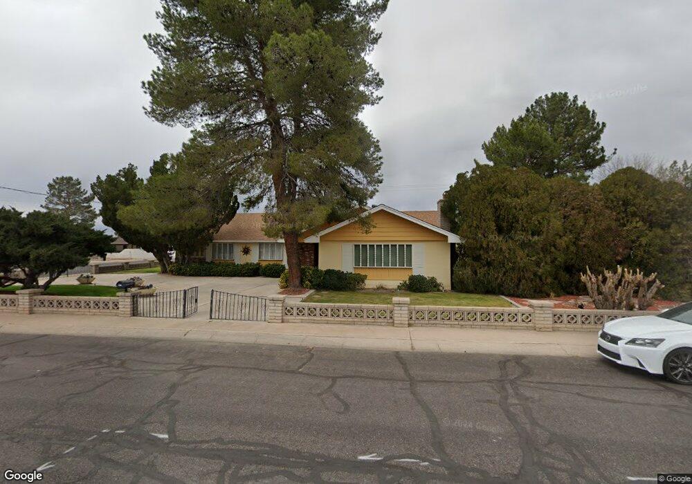
828 W Kimball Ln Safford, AZ 85546
Estimated Value: $334,204 - $433,000
--
Bed
--
Bath
2,489
Sq Ft
$155/Sq Ft
Est. Value
About This Home
This home is located at 828 W Kimball Ln, Safford, AZ 85546 and is currently estimated at $384,801, approximately $154 per square foot. 828 W Kimball Ln is a home located in Graham County with nearby schools including Ruth Powell Elementary School, Dorothy Stinson School, and Lafe Nelson School.
Ownership History
Date
Name
Owned For
Owner Type
Purchase Details
Closed on
Jun 18, 2019
Sold by
Haralson Ian Keith and Haralson Devin Kyle
Bought by
Haralson Vicki G
Current Estimated Value
Purchase Details
Closed on
Aug 11, 2008
Sold by
Marshall Curtis P and Marshall Diana K
Bought by
Sirva Relocation Credit Llc
Purchase Details
Closed on
Sep 17, 2007
Sold by
Haralson Danny Keith and Haralson Vicki G
Bought by
The Danny K & Vicki G Haralson Living Tr
Create a Home Valuation Report for This Property
The Home Valuation Report is an in-depth analysis detailing your home's value as well as a comparison with similar homes in the area
Home Values in the Area
Average Home Value in this Area
Purchase History
| Date | Buyer | Sale Price | Title Company |
|---|---|---|---|
| Haralson Vicki G | -- | None Available | |
| Haralson Vicki G | -- | None Available | |
| Sirva Relocation Credit Llc | -- | Safford Title Agency | |
| The Danny K & Vicki G Haralson Living Tr | -- | None Available |
Source: Public Records
Tax History Compared to Growth
Tax History
| Year | Tax Paid | Tax Assessment Tax Assessment Total Assessment is a certain percentage of the fair market value that is determined by local assessors to be the total taxable value of land and additions on the property. | Land | Improvement |
|---|---|---|---|---|
| 2026 | $1,200 | -- | -- | -- |
| 2025 | $1,200 | $28,386 | $2,856 | $25,530 |
| 2024 | $1,238 | $26,748 | $2,856 | $23,892 |
| 2023 | $1,238 | $21,400 | $2,856 | $18,544 |
| 2022 | $1,551 | $19,284 | $2,856 | $16,428 |
| 2021 | $1,763 | $0 | $0 | $0 |
| 2020 | $1,696 | $0 | $0 | $0 |
| 2019 | $1,792 | $0 | $0 | $0 |
| 2018 | $1,765 | $0 | $0 | $0 |
| 2017 | $1,582 | $0 | $0 | $0 |
| 2016 | $1,453 | $0 | $0 | $0 |
| 2015 | $1,326 | $0 | $0 | $0 |
Source: Public Records
Map
Nearby Homes
- 1309 S Bingham Place
- 813 W 13th St
- 1536 W Cherokee Ln
- 1227 S 7th Ave
- 1115 W Relation St
- 1108 S 9th Ave
- 1101 S 9th Place
- 1116 S 6th Ave
- 1808 Mesa Cir
- 1906 S Elm Ave
- 1104 S Central Ave
- 120 Relation St Unit 2
- 115 W 15th St
- 1210 S 1st Ave
- 1204 S 1st Ave
- 2190 S Mason Way
- 616 W 7th St
- 1544 Stone Willow Dr
- 1017 W Tucson St
- 860 S Flagstone Way
- 816 W Kimball Ln
- 821 W Relation St
- 1402 W Kimball St
- 829 W Kimball Ln
- 815 W Relation St
- 810 W Kimball Ln
- 903 W Relation St
- 1501 S 9th Ave
- 809 W Kimball Ln
- 936 W Kimball Ln
- 828 W Navajo Ln
- 1400 S 8th Ave
- 822 W Navajo Ln
- 824 W Relation St
- 909 W Relation St
- 1504 S 9th Ave
- 1475 W Cherokee Ln
- 816 W Navajo Ln
- 804 W Kimball Ln
- 1328 S 9th Ave