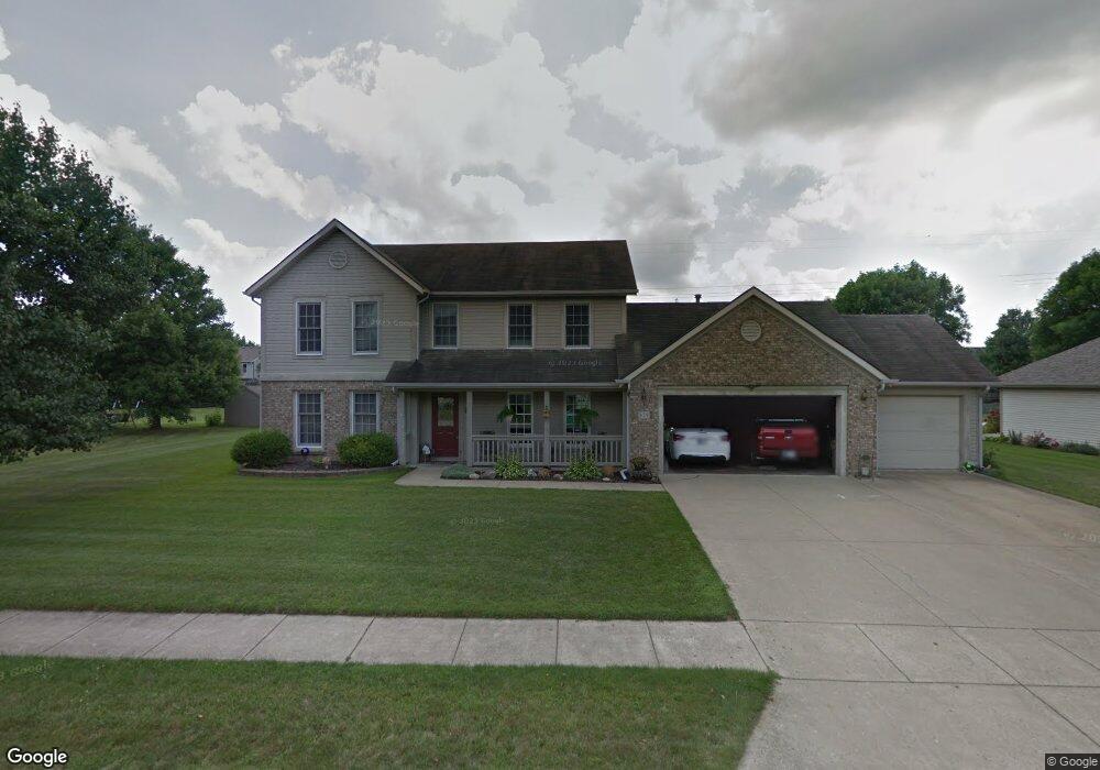
829 Brookside Dr Lafayette, IN 47909
Estimated Value: $343,000 - $361,000
4
Beds
3
Baths
2,192
Sq Ft
$159/Sq Ft
Est. Value
About This Home
This home is located at 829 Brookside Dr, Lafayette, IN 47909 and is currently estimated at $348,834, approximately $159 per square foot. 829 Brookside Dr is a home located in Tippecanoe County with nearby schools including Amelia Earhart Elementary School, Lafayette Tecumseh Junior High School, and Sunnyside Intermediate School.
Ownership History
Date
Name
Owned For
Owner Type
Purchase Details
Closed on
Jun 25, 2009
Sold by
Webb Joshua and Webb Donia S
Bought by
Bell Steven E and Bell Theresa J
Current Estimated Value
Home Financials for this Owner
Home Financials are based on the most recent Mortgage that was taken out on this home.
Original Mortgage
$166,920
Outstanding Balance
$105,861
Interest Rate
4.92%
Mortgage Type
FHA
Estimated Equity
$242,973
Purchase Details
Closed on
Jul 29, 2004
Sold by
Vanlaere Ronald A and Vanlaere Linda S
Bought by
Webb Joshua and Webb Donia S
Home Financials for this Owner
Home Financials are based on the most recent Mortgage that was taken out on this home.
Original Mortgage
$158,000
Interest Rate
6.4%
Mortgage Type
Unknown
Create a Home Valuation Report for This Property
The Home Valuation Report is an in-depth analysis detailing your home's value as well as a comparison with similar homes in the area
Purchase History
| Date | Buyer | Sale Price | Title Company |
|---|---|---|---|
| Bell Steven E | -- | None Available | |
| Webb Joshua | -- | -- |
Source: Public Records
Mortgage History
| Date | Status | Borrower | Loan Amount |
|---|---|---|---|
| Open | Bell Steven E | $166,920 | |
| Previous Owner | Webb Joshua | $158,000 |
Source: Public Records
Tax History
| Year | Tax Paid | Tax Assessment Tax Assessment Total Assessment is a certain percentage of the fair market value that is determined by local assessors to be the total taxable value of land and additions on the property. | Land | Improvement |
|---|---|---|---|---|
| 2024 | $2,733 | $273,300 | $53,000 | $220,300 |
| 2023 | $2,605 | $259,300 | $53,000 | $206,300 |
| 2022 | $1,954 | $196,000 | $30,000 | $166,000 |
| 2021 | $1,836 | $184,200 | $30,000 | $154,200 |
| 2020 | $1,718 | $172,400 | $30,000 | $142,400 |
| 2019 | $1,647 | $165,300 | $30,000 | $135,300 |
| 2018 | $1,627 | $161,700 | $30,000 | $131,700 |
| 2017 | $1,620 | $161,000 | $30,000 | $131,000 |
| 2016 | $1,591 | $158,600 | $30,000 | $128,600 |
| 2014 | $1,423 | $148,900 | $30,000 | $118,900 |
| 2013 | $1,334 | $144,100 | $30,000 | $114,100 |
Source: Public Records
Map
Nearby Homes
- 12 Brookhill Ct
- 601 Old Farm Rd
- 1007 Waterstone Dr
- 3500 Waverly Dr
- 3303 Crosspoint Ct S
- 3713 John Adams Rd
- 3435 Coventry Ln
- 3401 S 11th St
- 3442 Teasdale Ct
- 3920 George Washington Rd
- 3416 Coventry Ln
- 1301 Norma Jean Dr
- 1401 Normandy Dr
- 8151 John Adams Rd
- 8165 John Adams Rd
- 8171 John Adams Rd
- 8157 John Adams Rd
- TBD John Adams Rd
- 904 N Southland Dr
- 1920 Honeybrook Way
- 825 Brookside Dr
- 833 Brookside Dr
- 41 Brookberry Dr
- 828 Brookside Dr
- 932 Brookridge Ct
- 821 Brookside Dr
- 824 Brookside Dr
- 837 Brookside Dr
- 817 Brookside Dr
- 43 Brookdale Ct
- 820 Brookside Dr
- 13 Brookdale Ct
- 31 Brookberry Dr
- 928 Brookridge Ct
- 61 Brookberry Dr
- 935 Brookridge Ct
- 816 Brookside Dr
- 21 Brookberry Dr
- 33 Brookdale Ct
- 71 Brookberry Dr
Your Personal Tour Guide
Ask me questions while you tour the home.