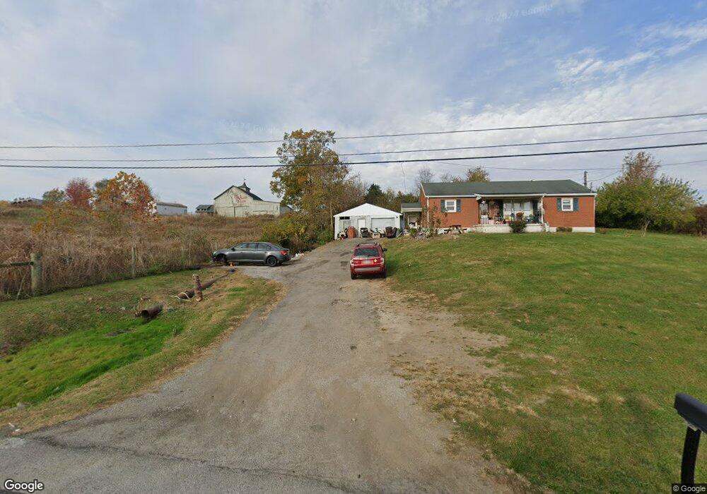
8293 State Route 41 West Union, OH 45693
Estimated Value: $120,000 - $187,000
3
Beds
1
Bath
1,376
Sq Ft
$111/Sq Ft
Est. Value
About This Home
This home is located at 8293 State Route 41, West Union, OH 45693 and is currently estimated at $152,058, approximately $110 per square foot. 8293 State Route 41 is a home located in Adams County with nearby schools including Manchester Elementary School, Manchester High School, and Adams County Christian School.
Ownership History
Date
Name
Owned For
Owner Type
Purchase Details
Closed on
Jan 22, 2018
Sold by
Fannie Mae
Bought by
Willis Daniel K
Current Estimated Value
Home Financials for this Owner
Home Financials are based on the most recent Mortgage that was taken out on this home.
Original Mortgage
$59,144
Interest Rate
4.4%
Mortgage Type
VA
Purchase Details
Closed on
May 26, 2017
Sold by
Walker Edgar T
Bought by
Federal National Mortgage Associati
Purchase Details
Closed on
Sep 10, 1998
Bought by
Walker Edgar T
Create a Home Valuation Report for This Property
The Home Valuation Report is an in-depth analysis detailing your home's value as well as a comparison with similar homes in the area
Home Values in the Area
Average Home Value in this Area
Purchase History
| Date | Buyer | Sale Price | Title Company |
|---|---|---|---|
| Willis Daniel K | -- | Ohio Title Corp | |
| Federal National Mortgage Associati | -- | -- | |
| Walker Edgar T | $61,000 | -- |
Source: Public Records
Mortgage History
| Date | Status | Borrower | Loan Amount |
|---|---|---|---|
| Previous Owner | Willis Daniel K | $59,144 |
Source: Public Records
Tax History Compared to Growth
Tax History
| Year | Tax Paid | Tax Assessment Tax Assessment Total Assessment is a certain percentage of the fair market value that is determined by local assessors to be the total taxable value of land and additions on the property. | Land | Improvement |
|---|---|---|---|---|
| 2024 | $869 | $29,260 | $4,410 | $24,850 |
| 2023 | $960 | $29,260 | $4,410 | $24,850 |
| 2022 | $869 | $25,760 | $3,290 | $22,470 |
| 2021 | $801 | $25,760 | $3,290 | $22,470 |
| 2020 | $777 | $25,760 | $3,290 | $22,470 |
| 2019 | $764 | $25,760 | $3,290 | $22,470 |
| 2018 | $841 | $22,820 | $3,290 | $19,530 |
| 2017 | $725 | $22,820 | $3,290 | $19,530 |
| 2016 | $719 | $22,820 | $3,290 | $19,530 |
| 2015 | $750 | $24,640 | $3,430 | $21,210 |
| 2014 | $750 | $24,640 | $3,430 | $21,210 |
Source: Public Records
Map
Nearby Homes
- 223 Polk St
- 1070 Eagle Creek Rd
- 9598 State Route 41
- 1300 Bentonville Rd
- 126 Robinson Hollow Rd
- 40 Greenwood Ave
- 271 Crawford Rd
- 333 Crawford Rd
- 43 Hill Crest Ln
- 81 Evergreen St
- 43 Hillcrest Ln
- 88 Rayborn Rd
- 0 Old Dutch Rd Unit (Tract 2 at Old Dutc
- 0 Old Dutch Rd Unit 25463381
- 0 Old Dutch Rd Unit (Tract 3 at Old Dutc
- 0 Old Dutch Rd Unit 25041806
- 0 Old Dutch Rd Unit 25463405
- 0 Old Dutch Rd Unit (Tract 1 at Old Dutc
- 0 State Route 136 Lot Unit Wp001
- 0 Cic Blvd
- 8293 St Rt 41
- 8125 State Route 41
- 8085 State Route 41
- 8525 State Route 41
- 7925 State Route 41
- 8589 State Route 41
- 8637 State Route 41
- 8637 St Rt 41
- 7949 State Route 41
- 7949 State Route 41
- 7949 State Route 41
- 8686 State Route 41
- 8686 State Route 41
- 7887 State Route 41
- 89 Polk St
- 8697 Sr 41
- 8697 State Route 41
- 7869 State Route 41
- 8697 State Route 41
- 7855 State Route 41