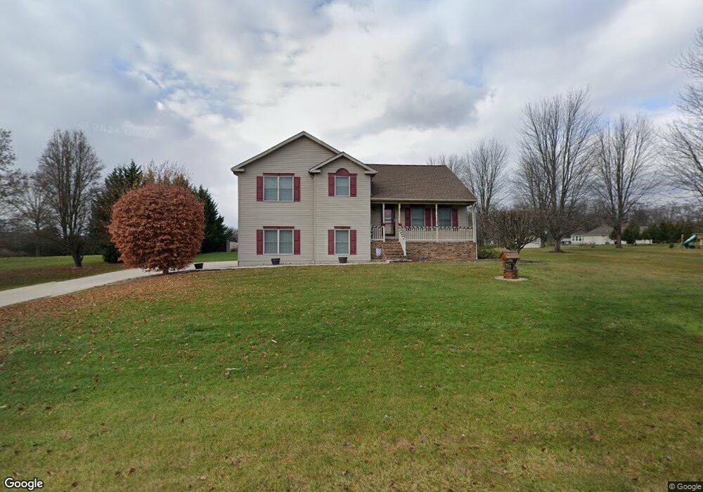
83 N Pheasant Way Unit 37 Abbottstown, PA 17301
Estimated Value: $321,000 - $373,000
3
Beds
2
Baths
1,363
Sq Ft
$257/Sq Ft
Est. Value
About This Home
This home is located at 83 N Pheasant Way Unit 37, Abbottstown, PA 17301 and is currently estimated at $350,958, approximately $257 per square foot. 83 N Pheasant Way Unit 37 is a home located in Adams County with nearby schools including New Oxford Senior High School and Paradise School.
Ownership History
Date
Name
Owned For
Owner Type
Purchase Details
Closed on
Nov 19, 2002
Bought by
Harlacher Scott A
Current Estimated Value
Create a Home Valuation Report for This Property
The Home Valuation Report is an in-depth analysis detailing your home's value as well as a comparison with similar homes in the area
Home Values in the Area
Average Home Value in this Area
Purchase History
| Date | Buyer | Sale Price | Title Company |
|---|---|---|---|
| Harlacher Scott A | $34,500 | -- |
Source: Public Records
Tax History Compared to Growth
Tax History
| Year | Tax Paid | Tax Assessment Tax Assessment Total Assessment is a certain percentage of the fair market value that is determined by local assessors to be the total taxable value of land and additions on the property. | Land | Improvement |
|---|---|---|---|---|
| 2025 | $5,359 | $236,400 | $68,000 | $168,400 |
| 2024 | $4,927 | $236,400 | $68,000 | $168,400 |
| 2023 | $4,734 | $236,400 | $68,000 | $168,400 |
| 2022 | $4,580 | $236,400 | $68,000 | $168,400 |
| 2021 | $4,455 | $236,400 | $68,000 | $168,400 |
| 2020 | $4,344 | $236,400 | $68,000 | $168,400 |
| 2019 | $4,248 | $236,400 | $68,000 | $168,400 |
| 2018 | $4,152 | $236,400 | $68,000 | $168,400 |
| 2017 | $3,969 | $236,400 | $68,000 | $168,400 |
| 2016 | -- | $236,400 | $68,000 | $168,400 |
| 2015 | -- | $236,400 | $68,000 | $168,400 |
| 2014 | -- | $236,400 | $68,000 | $168,400 |
Source: Public Records
Map
Nearby Homes
- 334 Rolling Ln Unit 2
- 290 Woods Rd Unit 1
- 60 Hunters Cir Unit 19
- 484 Brough Rd
- 0 Woods Rd
- 486 W King St
- 224 W King St
- 507 Bullet Way
- 6 Lobell Rd
- 201 Kinneman Rd Unit 25
- 221 Kinneman Rd Unit 28
- 28 Town Cir Unit 12A
- 6431 York Rd
- 3436 Carlisle Pike
- 3392 Carlisle Pike
- 115 Creekland Dr Unit 4
- 278 Runaway Rd
- 22 Meadowview Ln
- 702 Wind In the Willows
- 70 Peepytown Rd
- 89 N Pheasant Way Unit 36
- 77 N Pheasant Way Unit 38
- 82 N Pheasant Way Unit 34
- 88 N Pheasant Way Unit 35
- 76 N Pheasant Way Unit 33
- 71 N Pheasant Way Unit 39
- 23 Fox Run Rd Unit 42
- 70 N Pheasant Way Unit 32
- 35 Fox Run Rd Unit 40
- 29 Fox Run Rd Unit 41
- 64 N Pheasant Way Unit 31
- 11 Fox Run Rd Unit 44
- 978 Forest Dr Unit 8
- 58 N Pheasant Way Unit 30
- 30 Fox Run Rd Unit 49
- 5 Fox Run Rd Unit 45
- 20 Fox Run Rd Unit 48
- 8 Fox Run Rd Unit 46
- 57 N Pheasant Way Unit 50
- 1053 Forest Dr Unit 47