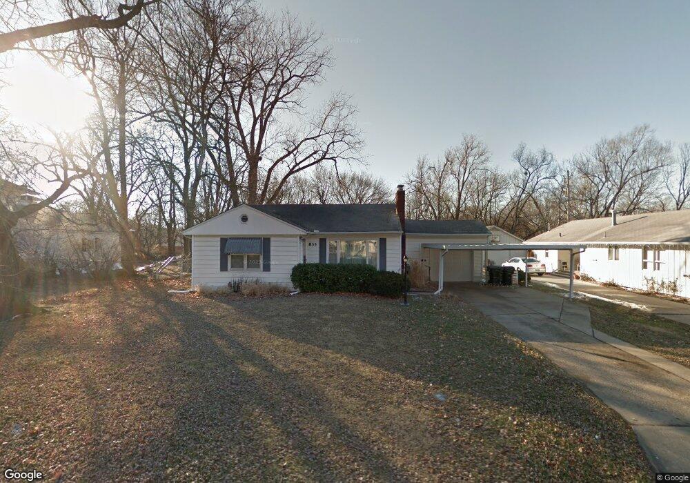
833 SW High Ave Topeka, KS 66606
Central Topeka NeighborhoodEstimated Value: $147,000 - $162,000
2
Beds
2
Baths
1,146
Sq Ft
$133/Sq Ft
Est. Value
About This Home
This home is located at 833 SW High Ave, Topeka, KS 66606 and is currently estimated at $152,984, approximately $133 per square foot. 833 SW High Ave is a home located in Shawnee County with nearby schools including Martin Park Elementary School, Lowman Hill Elementary School, and Landon Middle School.
Ownership History
Date
Name
Owned For
Owner Type
Purchase Details
Closed on
Oct 28, 2005
Sold by
Edwards Megan K and Walawender Brian P
Bought by
Decker Catherine M
Current Estimated Value
Home Financials for this Owner
Home Financials are based on the most recent Mortgage that was taken out on this home.
Original Mortgage
$72,000
Outstanding Balance
$38,699
Interest Rate
5.73%
Mortgage Type
New Conventional
Estimated Equity
$114,285
Create a Home Valuation Report for This Property
The Home Valuation Report is an in-depth analysis detailing your home's value as well as a comparison with similar homes in the area
Home Values in the Area
Average Home Value in this Area
Purchase History
| Date | Buyer | Sale Price | Title Company |
|---|---|---|---|
| Decker Catherine M | -- | Capital Title Insurace Compa |
Source: Public Records
Mortgage History
| Date | Status | Borrower | Loan Amount |
|---|---|---|---|
| Open | Decker Catherine M | $72,000 |
Source: Public Records
Tax History Compared to Growth
Tax History
| Year | Tax Paid | Tax Assessment Tax Assessment Total Assessment is a certain percentage of the fair market value that is determined by local assessors to be the total taxable value of land and additions on the property. | Land | Improvement |
|---|---|---|---|---|
| 2025 | $2,252 | $16,769 | -- | -- |
| 2023 | $2,252 | $15,215 | $0 | $0 |
| 2022 | $2,053 | $13,875 | $0 | $0 |
| 2021 | $1,885 | $12,065 | $0 | $0 |
| 2020 | $1,773 | $11,490 | $0 | $0 |
| 2019 | $1,748 | $11,265 | $0 | $0 |
| 2018 | $1,698 | $10,937 | $0 | $0 |
| 2017 | $1,701 | $10,937 | $0 | $0 |
| 2014 | $1,718 | $10,937 | $0 | $0 |
Source: Public Records
Map
Nearby Homes
- 804 SW High Ave
- 923 SW High Ave
- 2330 SW Hazelton Ct
- 626 SW Medford Ave
- 1022 SW MacVicar Ave
- 2204 SW Kensington Ct
- 618 SW Randolph Ave
- 614 SW Webster Ave
- 2235 SW Kenilworth Ct
- 2012 SW 10th Ave
- 3005 SW 6th Ave Unit 6th
- 801 SW Lindenwood Ave
- 829 SW Oakley Ave
- 808 SW Lindenwood Ave
- 734 SW Lindenwood Ave
- 1147 SW Webster Ave
- 1115 SW Billard Ave
- 1164 SW MacVicar Ave
- 1150 SW Collins Ave
- 719 SW Jewell Ave
- 825 SW High Ave
- 2500 SW 9th St
- 832 SW High Ave
- 836 SW High Ave
- 815 SW High Ave
- 2416 SW 9th St
- 828 SW High Ave
- 2520 SW 9th St
- 824 SW High Ave
- 901 SW High Ave
- 2412 SW 9th St
- 814 SW High Ave
- 900 SW Medford Ave
- 814 SW Medford Ave
- 811 SW High Ave
- 905 SW High Ave
- 2600 SW 9th St
- 2406 SW 9th St
- 900 SW High Ave
- 812 SW High Ave