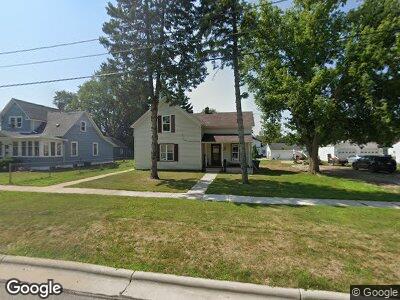
835 Elm St de Pere, WI 54115
Estimated Value: $184,524 - $248,000
3
Beds
2
Baths
1,567
Sq Ft
$140/Sq Ft
Est. Value
About This Home
This home is located at 835 Elm St, de Pere, WI 54115 and is currently estimated at $220,131, approximately $140 per square foot. 835 Elm St is a home located in Brown County with nearby schools including Westwood Elementary School, West De Pere Middle School, and West De Pere High School.
Ownership History
Date
Name
Owned For
Owner Type
Purchase Details
Closed on
Apr 19, 2024
Sold by
Rasmussen Wayne G
Bought by
Filler Cory
Current Estimated Value
Home Financials for this Owner
Home Financials are based on the most recent Mortgage that was taken out on this home.
Original Mortgage
$150,000
Outstanding Balance
$149,294
Interest Rate
10.36%
Estimated Equity
$59,270
Purchase Details
Closed on
Sep 4, 2020
Sold by
Rasmussen Wayne G
Bought by
Filler Cory
Home Financials for this Owner
Home Financials are based on the most recent Mortgage that was taken out on this home.
Original Mortgage
$22,000
Interest Rate
40%
Mortgage Type
Land Contract Argmt. Of Sale
Create a Home Valuation Report for This Property
The Home Valuation Report is an in-depth analysis detailing your home's value as well as a comparison with similar homes in the area
Home Values in the Area
Average Home Value in this Area
Purchase History
| Date | Buyer | Sale Price | Title Company |
|---|---|---|---|
| Filler Cory | -- | Liberty Title & Abstract Inc | |
| Filler Cory | $85,000 | Liberty Title |
Source: Public Records
Mortgage History
| Date | Status | Borrower | Loan Amount |
|---|---|---|---|
| Open | Filler Cory | $150,000 | |
| Previous Owner | Filler Cory | $22,000 |
Source: Public Records
Tax History Compared to Growth
Tax History
| Year | Tax Paid | Tax Assessment Tax Assessment Total Assessment is a certain percentage of the fair market value that is determined by local assessors to be the total taxable value of land and additions on the property. | Land | Improvement |
|---|---|---|---|---|
| 2024 | $2,027 | $129,200 | $37,000 | $92,200 |
| 2023 | $1,803 | $110,500 | $37,000 | $73,500 |
| 2022 | $1,807 | $100,100 | $37,000 | $63,100 |
| 2021 | $1,680 | $85,000 | $30,800 | $54,200 |
| 2020 | $2,860 | $130,500 | $30,800 | $99,700 |
| 2019 | $2,592 | $126,700 | $30,800 | $95,900 |
| 2018 | $2,429 | $115,300 | $30,800 | $84,500 |
| 2017 | $2,249 | $104,600 | $30,800 | $73,800 |
| 2016 | $2,258 | $104,600 | $30,800 | $73,800 |
| 2015 | $2,257 | $102,600 | $30,800 | $71,800 |
| 2014 | $2,187 | $102,600 | $30,800 | $71,800 |
| 2013 | $2,187 | $102,600 | $30,800 | $71,800 |
Source: Public Records
Map
Nearby Homes
- 840 Spruce St
- 555 Main Ave Unit 101
- 555 Main Ave Unit 206
- 3106 Trinity Ct
- 3166 Trinity Ct
- 1151 Grant St
- 656 Mollies Way
- 1401 Glory Rd
- 922 Amhart Dr
- 992 Aster Ct
- 980 Green Ridge Dr
- 312 N Michigan St
- 372 Battery Ave
- 304 Battery Ave
- 413 Brookline Ave
- 410 Battery Ave
- 416 Lansdowne St
- 305 Battery Ave
- 363 Battery Ave
- 400 Battery Ave