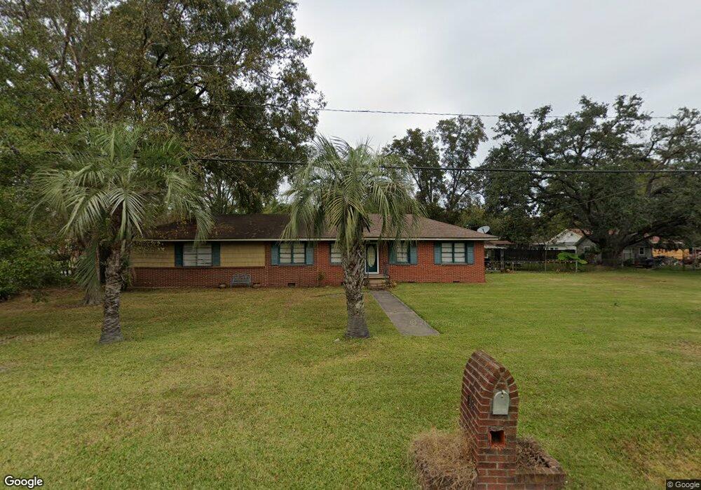
836 Crossgate Rd Savannah, GA 31407
Estimated Value: $232,000 - $264,000
3
Beds
2
Baths
1,623
Sq Ft
$157/Sq Ft
Est. Value
About This Home
This home is located at 836 Crossgate Rd, Savannah, GA 31407 and is currently estimated at $255,116, approximately $157 per square foot. 836 Crossgate Rd is a home located in Chatham County with nearby schools including Otis J. Brock Elementary School and Groves High School.
Ownership History
Date
Name
Owned For
Owner Type
Purchase Details
Closed on
Feb 11, 2011
Sold by
Davis Kathleen Usher
Bought by
Rollf Wanda D
Current Estimated Value
Home Financials for this Owner
Home Financials are based on the most recent Mortgage that was taken out on this home.
Original Mortgage
$90,500
Outstanding Balance
$3,323
Interest Rate
4.04%
Mortgage Type
New Conventional
Estimated Equity
$251,793
Create a Home Valuation Report for This Property
The Home Valuation Report is an in-depth analysis detailing your home's value as well as a comparison with similar homes in the area
Home Values in the Area
Average Home Value in this Area
Purchase History
| Date | Buyer | Sale Price | Title Company |
|---|---|---|---|
| Rollf Wanda D | $95,000 | -- | |
| Rollf Wanda D | $95,000 | -- |
Source: Public Records
Mortgage History
| Date | Status | Borrower | Loan Amount |
|---|---|---|---|
| Open | Rollf Wanda D | $90,500 | |
| Closed | Rollf Wanda D | $90,500 |
Source: Public Records
Tax History Compared to Growth
Tax History
| Year | Tax Paid | Tax Assessment Tax Assessment Total Assessment is a certain percentage of the fair market value that is determined by local assessors to be the total taxable value of land and additions on the property. | Land | Improvement |
|---|---|---|---|---|
| 2025 | $1,287 | $96,600 | $16,000 | $80,600 |
| 2024 | $1,287 | $82,800 | $12,000 | $70,800 |
| 2023 | $721 | $85,120 | $13,800 | $71,320 |
| 2022 | $1,124 | $61,480 | $9,200 | $52,280 |
| 2021 | $1,094 | $44,680 | $6,000 | $38,680 |
| 2020 | $1,174 | $46,120 | $6,000 | $40,120 |
| 2019 | $1,174 | $46,120 | $6,000 | $40,120 |
| 2018 | $963 | $37,440 | $6,000 | $31,440 |
| 2017 | $855 | $36,440 | $6,000 | $30,440 |
| 2016 | $868 | $36,920 | $6,280 | $30,640 |
| 2015 | $1,510 | $41,720 | $6,280 | $35,440 |
| 2014 | $1,660 | $41,720 | $0 | $0 |
Source: Public Records
Map
Nearby Homes
- 111 Gordon St
- 106 Gordon St
- 214 Cantyre St
- 115 Aberfeldy St
- 206 Turnberry St
- 410 Turnberry St
- 55 Warren Dr
- 21 Coleraine Dr
- 211 Osteen St
- 7 Coleraine Dr
- 303 Armadale Rd
- 109 Appleby Rd
- 204 Antrim St
- 0 Augusta Rd Unit 314758
- 34 Smith Ave
- 13 Ronnie Ave
- 67 Lynn Ave
- 108 Peabody St
- 116 Peabody St
- 97 Azalea Ave