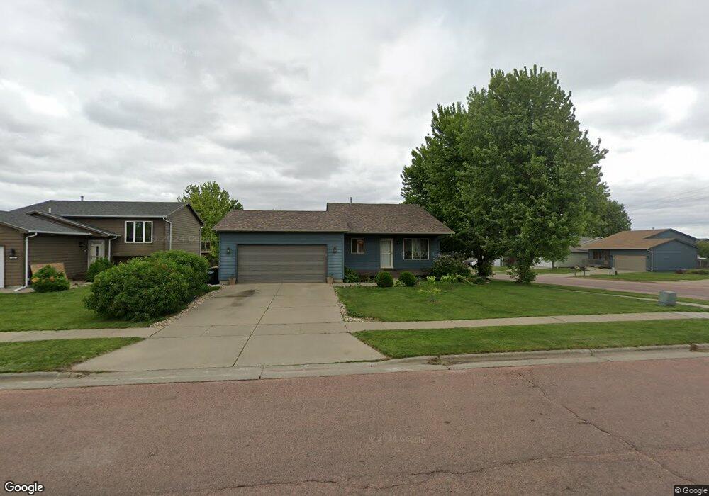
836 S Wheatland Ave Sioux Falls, SD 57106
Northwest Sioux Falls NeighborhoodEstimated Value: $289,000 - $316,000
3
Beds
2
Baths
1,489
Sq Ft
$203/Sq Ft
Est. Value
About This Home
This home is located at 836 S Wheatland Ave, Sioux Falls, SD 57106 and is currently estimated at $302,983, approximately $203 per square foot. 836 S Wheatland Ave is a home located in Minnehaha County with nearby schools including Discovery Elementary School, Memorial Middle School, and Jefferson High School - 67.
Ownership History
Date
Name
Owned For
Owner Type
Purchase Details
Closed on
Aug 14, 2014
Sold by
Eric J Eric J and Eric Van Roekel
Bought by
Taylor Shawna J and Taylor Nicholas A
Current Estimated Value
Home Financials for this Owner
Home Financials are based on the most recent Mortgage that was taken out on this home.
Original Mortgage
$142,405
Outstanding Balance
$108,543
Interest Rate
4.1%
Mortgage Type
New Conventional
Estimated Equity
$194,440
Create a Home Valuation Report for This Property
The Home Valuation Report is an in-depth analysis detailing your home's value as well as a comparison with similar homes in the area
Home Values in the Area
Average Home Value in this Area
Purchase History
| Date | Buyer | Sale Price | Title Company |
|---|---|---|---|
| Taylor Shawna J | $149,900 | -- |
Source: Public Records
Mortgage History
| Date | Status | Borrower | Loan Amount |
|---|---|---|---|
| Open | Taylor Shawna J | $142,405 |
Source: Public Records
Tax History
| Year | Tax Paid | Tax Assessment Tax Assessment Total Assessment is a certain percentage of the fair market value that is determined by local assessors to be the total taxable value of land and additions on the property. | Land | Improvement |
|---|---|---|---|---|
| 2024 | $3,675 | $268,800 | $29,800 | $239,000 |
| 2023 | $3,524 | $247,900 | $29,800 | $218,100 |
| 2022 | $3,317 | $219,700 | $29,800 | $189,900 |
| 2021 | $2,833 | $202,500 | $0 | $0 |
| 2020 | $2,833 | $179,300 | $0 | $0 |
| 2019 | $2,693 | $167,090 | $0 | $0 |
| 2018 | $2,480 | $163,641 | $0 | $0 |
| 2016 | $2,376 | $147,849 | $29,126 | $118,723 |
| 2015 | $2,336 | $139,695 | $27,507 | $112,188 |
| 2014 | $2,242 | $135,338 | $27,507 | $107,831 |
Source: Public Records
Map
Nearby Homes
- 1107 S President Ct
- 824 S Tanglewood Ave
- 1209 S Wheatland Ave
- 7816 W Kelsey Cir
- 1301 S Hyannis Port Ln
- 8709 W Rathburn St
- 1100 S Maria Ave
- 811 S Discovery Ave
- 1501 S Wheatland Ave
- 1516 S Kinderhook Ave
- 516 S Mary Gene Ave
- 1201 S Montpelier Ave Ave
- 521 S Big Stone Ave
- 8016 W Browning St
- 8101 W 24th St
- 8105 W 24th St
- 1508 S Kathryn Ave
- 1305 S Gill Ave
- 7512 W Stoney Creek St
- 701 S Gill Ave
- 832 S Wheatland Ave
- 828 S Wheatland Ave
- 825 S Whitewood Ave
- 821 S Whitewood Ave
- 8013 W Stoney Creek St
- 833 S Wheatland Ave
- 837 S Wheatland Ave
- 824 S Wheatland Ave
- 817 S Whitewood Ave
- 829 S Wheatland Ave
- 8005 W Stoney Creek St
- 901 S Wheatland Ave
- 820 S Wheatland Ave
- 825 S Wheatland Ave
- 813 S Whitewood Ave
- 8001 W Stoney Creek St
- 8001 W Stoney Creek St St
- 821 S Wheatland Ave
- 809 S Whitewood Ave
- 8105 W Stoney Creek St
Your Personal Tour Guide
Ask me questions while you tour the home.