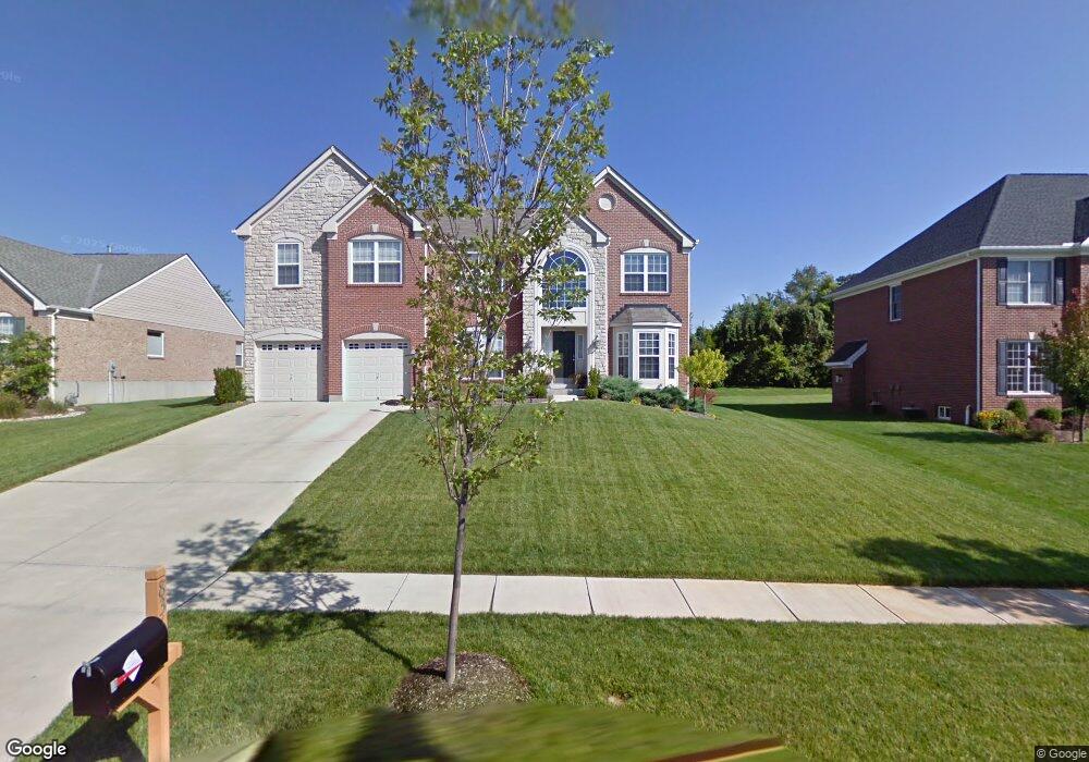
8365 Ashmont Way Mason, OH 45040
Deerfield Township NeighborhoodEstimated Value: $707,921 - $790,000
4
Beds
4
Baths
2,600
Sq Ft
$287/Sq Ft
Est. Value
About This Home
This home is located at 8365 Ashmont Way, Mason, OH 45040 and is currently estimated at $746,730, approximately $287 per square foot. 8365 Ashmont Way is a home located in Warren County with nearby schools including Mason Intermediate Elementary School, Mason Middle School, and William Mason High School.
Ownership History
Date
Name
Owned For
Owner Type
Purchase Details
Closed on
Aug 17, 2005
Sold by
The Drees Co
Bought by
Vrooman Stephen and Vrooman Carla
Current Estimated Value
Home Financials for this Owner
Home Financials are based on the most recent Mortgage that was taken out on this home.
Original Mortgage
$295,000
Interest Rate
5.93%
Mortgage Type
Fannie Mae Freddie Mac
Create a Home Valuation Report for This Property
The Home Valuation Report is an in-depth analysis detailing your home's value as well as a comparison with similar homes in the area
Home Values in the Area
Average Home Value in this Area
Purchase History
| Date | Buyer | Sale Price | Title Company |
|---|---|---|---|
| Vrooman Stephen | $368,833 | Landamerica |
Source: Public Records
Mortgage History
| Date | Status | Borrower | Loan Amount |
|---|---|---|---|
| Closed | Vrooman Stephen | $295,000 |
Source: Public Records
Tax History Compared to Growth
Tax History
| Year | Tax Paid | Tax Assessment Tax Assessment Total Assessment is a certain percentage of the fair market value that is determined by local assessors to be the total taxable value of land and additions on the property. | Land | Improvement |
|---|---|---|---|---|
| 2024 | $8,815 | $204,850 | $45,500 | $159,350 |
| 2023 | $8,122 | $155,386 | $26,950 | $128,436 |
| 2022 | $7,934 | $154,434 | $26,950 | $127,484 |
| 2021 | $7,549 | $154,434 | $26,950 | $127,484 |
| 2020 | $8,077 | $140,396 | $24,500 | $115,896 |
| 2019 | $7,489 | $140,396 | $24,500 | $115,896 |
| 2018 | $7,426 | $140,396 | $24,500 | $115,896 |
| 2017 | $7,834 | $135,002 | $25,106 | $109,897 |
| 2016 | $8,051 | $135,002 | $25,106 | $109,897 |
| 2015 | $6,974 | $126,648 | $25,106 | $101,542 |
| 2014 | $6,974 | $109,180 | $21,640 | $87,540 |
| 2013 | $6,989 | $123,580 | $24,500 | $99,080 |
Source: Public Records
Map
Nearby Homes
- 5398 Harbourwatch Way
- 5661 Baywatch Way
- 5626 Baywatch Way
- 8421 Cameron Ct
- 5369 N Shore Place
- 5754 Trailside Ct
- 8659 Coveview Ct
- 5532 Winding Cape Way
- 7693 Misty Springs Ct
- 7725 Livingston Dr
- 7648 Waterfront Way
- 7660 Waterfront Way
- 7692 Waterfront Way
- 7600 Waterfront Way
- 9147 Elizabeth Ln Unit 9147
- 7858 Yellowwood Dr
- 7911 Meadowbrook Dr
- 9120 Boylston St
- 7839 Meadowbrook Dr
- 4765 Mallard Creek Dr
- 8369 Ashmont Way
- 8361 Ashmont Way
- 8373 Ashmont Way
- 8357 Ashmont Way
- 8362 Ashmont Way
- 8370 Ashmont Way
- 8358 Ashmont Way
- 8353 Ashmont Way
- 8377 Ashmont Way
- A Socialville-Fosters Rd
- 8354 Ashmont Way
- 8344 Oakdale Ct
- 8343 Oakdale Ct
- 8222 Pineleigh Ct
- 8374 Ashmont Way
- 8381 Ashmont Way
- 8226 Pineleigh Ct
- 8350 Ashmont Way
- 8345 Oakdale Ct
- 8218 Pineleigh Ct