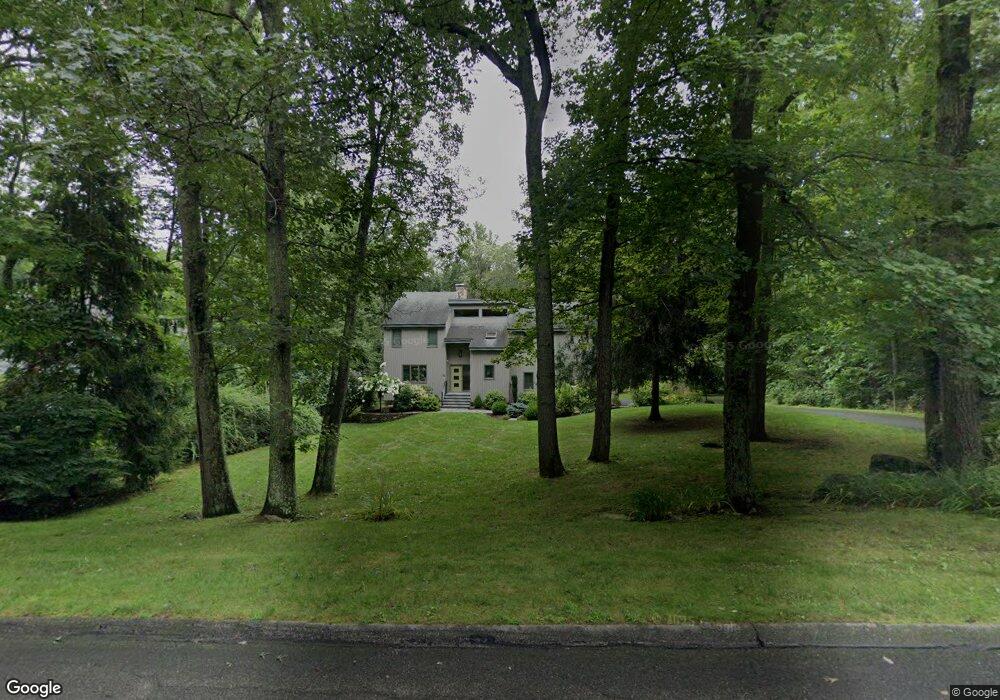
84 Denison Dr Guilford, CT 06437
Estimated Value: $714,812 - $849,000
4
Beds
3
Baths
2,314
Sq Ft
$332/Sq Ft
Est. Value
About This Home
This home is located at 84 Denison Dr, Guilford, CT 06437 and is currently estimated at $768,953, approximately $332 per square foot. 84 Denison Dr is a home located in New Haven County with nearby schools including E.C. Adams Middle School, A. Baldwin Middle School, and Guilford High School.
Ownership History
Date
Name
Owned For
Owner Type
Purchase Details
Closed on
Aug 14, 2008
Sold by
Ellis Arthur D and Ellis Joan F
Bought by
Gamache Michelle B and Cahill Maria A
Current Estimated Value
Home Financials for this Owner
Home Financials are based on the most recent Mortgage that was taken out on this home.
Original Mortgage
$348,000
Interest Rate
6.4%
Create a Home Valuation Report for This Property
The Home Valuation Report is an in-depth analysis detailing your home's value as well as a comparison with similar homes in the area
Home Values in the Area
Average Home Value in this Area
Purchase History
| Date | Buyer | Sale Price | Title Company |
|---|---|---|---|
| Gamache Michelle B | $435,000 | -- |
Source: Public Records
Mortgage History
| Date | Status | Borrower | Loan Amount |
|---|---|---|---|
| Open | Gamache Michelle B | $350,000 | |
| Closed | Gamache Michelle B | $356,000 | |
| Closed | Gamache Michelle B | $348,000 |
Source: Public Records
Tax History
| Year | Tax Paid | Tax Assessment Tax Assessment Total Assessment is a certain percentage of the fair market value that is determined by local assessors to be the total taxable value of land and additions on the property. | Land | Improvement |
|---|---|---|---|---|
| 2025 | $9,987 | $361,200 | $164,500 | $196,700 |
| 2024 | $9,601 | $361,200 | $164,500 | $196,700 |
| 2023 | $9,348 | $361,200 | $164,500 | $196,700 |
| 2022 | $9,052 | $272,230 | $148,400 | $123,830 |
| 2021 | $8,880 | $272,230 | $148,400 | $123,830 |
| 2020 | $8,796 | $272,230 | $148,400 | $123,830 |
| 2019 | $8,720 | $272,230 | $148,400 | $123,830 |
| 2018 | $8,515 | $272,230 | $148,400 | $123,830 |
| 2017 | $8,533 | $290,620 | $157,500 | $133,120 |
| 2016 | $8,332 | $290,620 | $157,500 | $133,120 |
| 2015 | $8,207 | $290,620 | $157,500 | $133,120 |
| 2014 | $7,969 | $290,620 | $157,500 | $133,120 |
Source: Public Records
Map
Nearby Homes
- 4 Copper Ridge Cir
- 16 Copper Hill Dr
- 48 Russett Dr
- 15 Copper Hill Dr Unit 15
- 106 Sconset Ln
- 14 Fox Ridge
- 60 Three Mile Course
- 51 Mill Rd
- 42 Granite Rd Unit 42
- 274 Church St Unit 3D
- 2455 Boston Post Rd Unit 9
- 401 Three Corners Rd
- 294 Church St
- 1800 Moose Hill Rd
- 7 River Colony Unit 7
- 95 Fair St
- 1941 Moose Hill Rd
- 223 Water St
- 1944 Moose Hill Rd
- LOT #22 Kenneth Cir Unit MAP 77
Your Personal Tour Guide
Ask me questions while you tour the home.