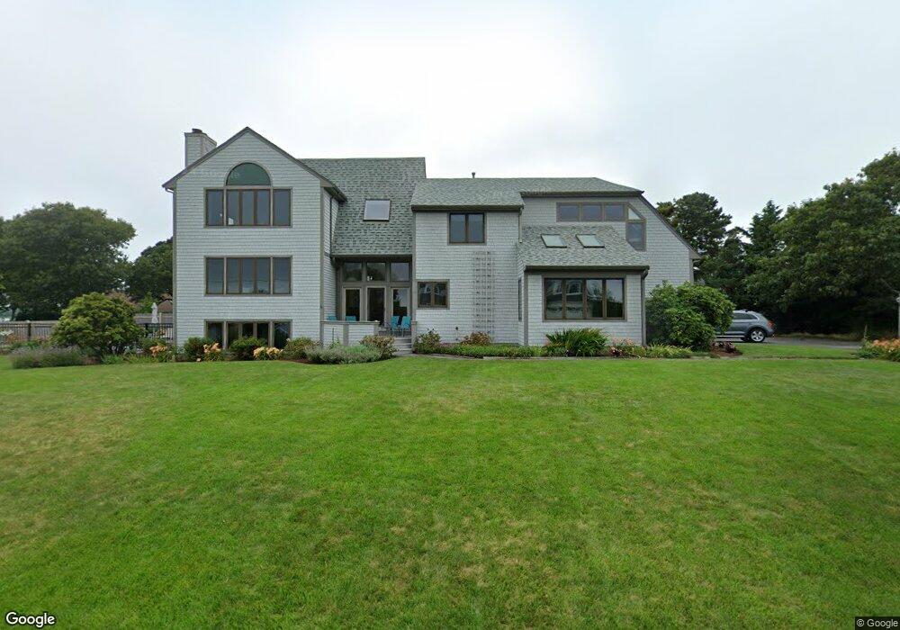
84 Elgin Rd Pocasset, MA 02559
Pocasset NeighborhoodEstimated Value: $1,422,000 - $2,185,000
3
Beds
4
Baths
3,648
Sq Ft
$484/Sq Ft
Est. Value
About This Home
This home is located at 84 Elgin Rd, Pocasset, MA 02559 and is currently estimated at $1,764,921, approximately $483 per square foot. 84 Elgin Rd is a home located in Barnstable County with nearby schools including Bourne High School and Cadence Academy Preschool - Bourne.
Ownership History
Date
Name
Owned For
Owner Type
Purchase Details
Closed on
Nov 28, 2014
Sold by
Smith Curtis R and Smith Anne B
Bought by
Curtis R Smith T R and Curtis Smith
Current Estimated Value
Purchase Details
Closed on
Apr 13, 2006
Sold by
Elgin Rt and Kisch
Bought by
Smith Anne B and Smith Curtis R
Purchase Details
Closed on
Apr 2, 2002
Sold by
Connole Rickart and Connole Joanne C
Bought by
Elgin Rt and Kisch Gleen E
Home Financials for this Owner
Home Financials are based on the most recent Mortgage that was taken out on this home.
Original Mortgage
$400,000
Interest Rate
6.88%
Mortgage Type
Purchase Money Mortgage
Create a Home Valuation Report for This Property
The Home Valuation Report is an in-depth analysis detailing your home's value as well as a comparison with similar homes in the area
Home Values in the Area
Average Home Value in this Area
Purchase History
| Date | Buyer | Sale Price | Title Company |
|---|---|---|---|
| Curtis R Smith T R | -- | -- | |
| Curtis R Smith T R | -- | -- | |
| Smith Anne B | $1,225,000 | -- | |
| Smith Anne B | $1,225,000 | -- | |
| Elgin Rt | $816,000 | -- | |
| Elgin Rt | $816,000 | -- |
Source: Public Records
Mortgage History
| Date | Status | Borrower | Loan Amount |
|---|---|---|---|
| Previous Owner | Elgin Rt | $400,000 |
Source: Public Records
Tax History Compared to Growth
Tax History
| Year | Tax Paid | Tax Assessment Tax Assessment Total Assessment is a certain percentage of the fair market value that is determined by local assessors to be the total taxable value of land and additions on the property. | Land | Improvement |
|---|---|---|---|---|
| 2025 | $10,774 | $1,379,500 | $744,500 | $635,000 |
| 2024 | $10,894 | $1,358,400 | $746,300 | $612,100 |
| 2023 | $8,588 | $974,800 | $462,400 | $512,400 |
| 2022 | $8,231 | $815,800 | $409,200 | $406,600 |
| 2021 | $7,997 | $742,500 | $372,400 | $370,100 |
| 2020 | $7,802 | $726,400 | $368,800 | $357,600 |
| 2019 | $9,541 | $907,800 | $428,100 | $479,700 |
| 2018 | $7,951 | $754,400 | $407,800 | $346,600 |
| 2017 | $8,143 | $790,600 | $447,400 | $343,200 |
| 2016 | $7,948 | $782,300 | $447,400 | $334,900 |
| 2015 | $7,878 | $782,300 | $447,400 | $334,900 |
Source: Public Records
Map
Nearby Homes
- 22 Nairn Rd
- 48 Red Brook Harbor Rd
- 3 Red Brook Pond Dr
- 1094 County Rd
- 171 Bellavista Dr
- 75 Winsor Rd
- 10 Squeteague Harbor Rd
- 34 Kenwood Rd
- 940 County Rd
- 45 Kenwood Rd
- 250 Scraggy Neck Rd
- 89 Harbor Dr
- 1234 Route 28a
- 1234 Route 28a
- 70 Wings Neck Rd
- 254 Barlows Landing Rd
- 24 Richmond Rd
- 940 County Rd
- 709 County Rd
- 14 Navajo Rd