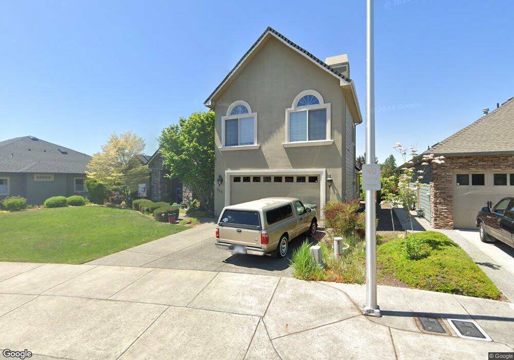
840 St Andrews Way Eagle Point, OR 97524
Estimated Value: $682,913 - $792,000
3
Beds
3
Baths
3,136
Sq Ft
$239/Sq Ft
Est. Value
About This Home
This home is located at 840 St Andrews Way, Eagle Point, OR 97524 and is currently estimated at $747,978, approximately $238 per square foot. 840 St Andrews Way is a home located in Jackson County with nearby schools including Eagle Point Middle School, White Mountain Middle School, and Eagle Point High School.
Ownership History
Date
Name
Owned For
Owner Type
Purchase Details
Closed on
Dec 30, 2021
Sold by
Camp Megan M
Bought by
Camp Megan Michelle and Megan Michelle Camp Revocable
Current Estimated Value
Purchase Details
Closed on
Dec 1, 2004
Sold by
Hoover David
Bought by
Camp Megan M
Home Financials for this Owner
Home Financials are based on the most recent Mortgage that was taken out on this home.
Original Mortgage
$399,920
Outstanding Balance
$199,213
Interest Rate
5.65%
Mortgage Type
Purchase Money Mortgage
Estimated Equity
$548,765
Purchase Details
Closed on
Apr 11, 2003
Sold by
Eagle Point Developments Llc
Bought by
Hoover David
Home Financials for this Owner
Home Financials are based on the most recent Mortgage that was taken out on this home.
Original Mortgage
$140,000
Interest Rate
5.71%
Mortgage Type
Purchase Money Mortgage
Create a Home Valuation Report for This Property
The Home Valuation Report is an in-depth analysis detailing your home's value as well as a comparison with similar homes in the area
Home Values in the Area
Average Home Value in this Area
Purchase History
| Date | Buyer | Sale Price | Title Company |
|---|---|---|---|
| Camp Megan Michelle | -- | None Available | |
| Camp Megan M | $449,900 | Lawyers Title Ins | |
| Hoover David | $140,000 | Lawyers Title Insurance Corp |
Source: Public Records
Mortgage History
| Date | Status | Borrower | Loan Amount |
|---|---|---|---|
| Open | Camp Megan M | $399,920 | |
| Previous Owner | Hoover David | $140,000 |
Source: Public Records
Tax History Compared to Growth
Tax History
| Year | Tax Paid | Tax Assessment Tax Assessment Total Assessment is a certain percentage of the fair market value that is determined by local assessors to be the total taxable value of land and additions on the property. | Land | Improvement |
|---|---|---|---|---|
| 2025 | $6,306 | $460,830 | $142,870 | $317,960 |
| 2024 | $6,306 | $447,410 | $138,710 | $308,700 |
| 2023 | $6,092 | $434,380 | $134,670 | $299,710 |
| 2022 | $5,925 | $434,380 | $134,670 | $299,710 |
| 2021 | $5,750 | $421,730 | $130,740 | $290,990 |
| 2020 | $6,109 | $409,450 | $126,930 | $282,520 |
| 2019 | $6,015 | $385,960 | $119,640 | $266,320 |
| 2018 | $5,901 | $374,720 | $116,160 | $258,560 |
| 2017 | $5,756 | $374,720 | $116,160 | $258,560 |
| 2016 | $5,644 | $353,220 | $109,490 | $243,730 |
| 2015 | $5,459 | $353,220 | $109,490 | $243,730 |
| 2014 | $5,303 | $332,960 | $103,200 | $229,760 |
Source: Public Records
Map
Nearby Homes
- 828 St Andrews Way
- 888 Arrowhead Trail
- 131 Bellerive Dr
- 875 St Andrews Way
- 118 Pebble Creek Dr
- 964 Pumpkin Ridge
- 599 Arrowhead Trail
- 162 Bellerive Dr
- 949 Arrowhead Trail
- 24 Blackstone Ct
- 997 Arrowhead Trail
- 203 Bellerive Dr
- 210 Bellerive Dr
- 220 Pine Lake Dr
- 131 Spanish Bay Ct
- 158 Prairie Landing Dr
- 522 Meadow Ln
- 323 S Shasta Ave
- 421 Stevens Rd Unit 14
- 421 Stevens Rd Unit 52
- 834 St Andrews Way
- 1099 Oak Grove Ct
- 833 St Andrews Way
- 828 St Andrews Lot 139 Way
- 1097 Oak Grove Ct
- 839 Saint Andrews Way
- 839 St Andrews Way
- 827 St Andrews Way
- 827 Saint Andrews Way
- 824 St Andrews Way
- 1091 Oak Grove Ct
- 1094 Oak Grove Ct
- 845 St Andrews Way
- 821 St Andrews Way
- 41 Aspen Ct
- 820 St Andrews Way
- 1085 Oak Grove Ct
- 851 St Andrews Way
- 35 Aspen Ct
- 815 St Andrews Way