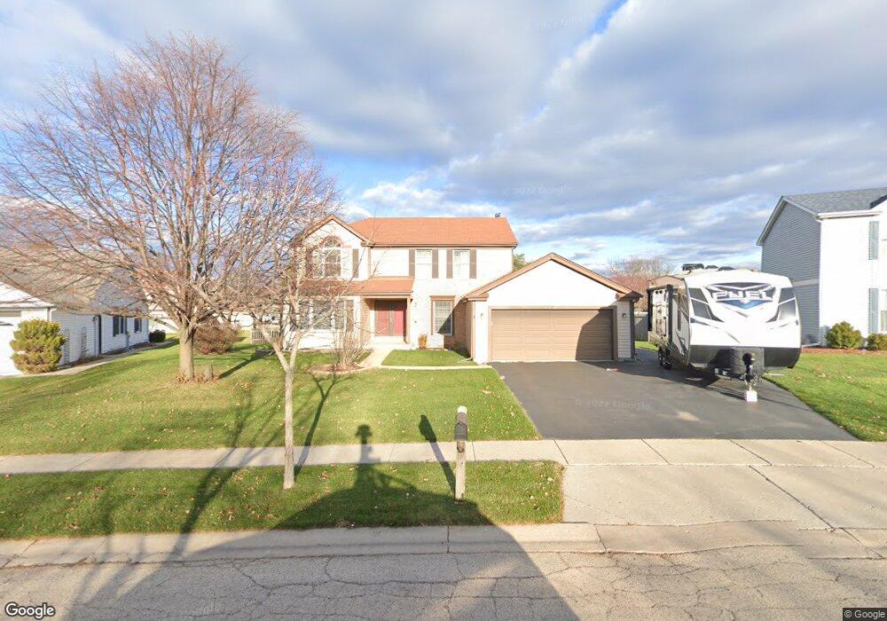
841 Providence Dr Algonquin, IL 60102
High Hill Farms NeighborhoodEstimated Value: $389,510 - $479,000
4
Beds
3
Baths
2,528
Sq Ft
$173/Sq Ft
Est. Value
About This Home
This home is located at 841 Providence Dr, Algonquin, IL 60102 and is currently estimated at $436,628, approximately $172 per square foot. 841 Providence Dr is a home located in McHenry County with nearby schools including Westfield Community School, Kenneth E Neubert Elementary School, and Harry D Jacobs High School.
Ownership History
Date
Name
Owned For
Owner Type
Purchase Details
Closed on
Jul 5, 2017
Sold by
Wisiewski Thomas J
Bought by
Wisnewski Thomas J
Current Estimated Value
Purchase Details
Closed on
Nov 15, 2016
Sold by
Wiseniewski Thomas J and Wiseniewski Delores
Bought by
Wisniewski Donald J and Wisniewski Thomas J
Purchase Details
Closed on
Feb 24, 2016
Sold by
Wisniewski Victor J and Wisniewski Thomas J
Bought by
Wisniewski Thomas J
Purchase Details
Closed on
Dec 7, 1993
Sold by
Wisniewski Victor J and Wisniewski Delores
Bought by
Wisniewski Thomas and Wisniewski Victor J
Create a Home Valuation Report for This Property
The Home Valuation Report is an in-depth analysis detailing your home's value as well as a comparison with similar homes in the area
Home Values in the Area
Average Home Value in this Area
Purchase History
| Date | Buyer | Sale Price | Title Company |
|---|---|---|---|
| Wisnewski Thomas J | -- | None Available | |
| Wisniewski Donald J | -- | None Available | |
| Wisniewski Thomas J | -- | None Available | |
| Wisniewski Thomas | -- | -- |
Source: Public Records
Tax History
| Year | Tax Paid | Tax Assessment Tax Assessment Total Assessment is a certain percentage of the fair market value that is determined by local assessors to be the total taxable value of land and additions on the property. | Land | Improvement |
|---|---|---|---|---|
| 2024 | $9,216 | $125,805 | $24,742 | $101,063 |
| 2023 | $8,749 | $112,517 | $22,129 | $90,388 |
| 2022 | $9,317 | $114,647 | $21,044 | $93,603 |
| 2021 | $8,945 | $106,807 | $19,605 | $87,202 |
| 2020 | $8,712 | $103,026 | $18,911 | $84,115 |
| 2019 | $8,504 | $98,608 | $18,100 | $80,508 |
| 2018 | $8,111 | $91,093 | $16,721 | $74,372 |
| 2017 | $7,948 | $85,815 | $15,752 | $70,063 |
| 2016 | $7,833 | $80,487 | $14,774 | $65,713 |
| 2013 | -- | $79,984 | $13,783 | $66,201 |
Source: Public Records
Map
Nearby Homes
- 1820 Crofton Dr
- 700 Fairfield Ln
- 1002 Interloch Ct Unit 152
- 760 Regal Ln
- 681 Majestic Dr
- 1 N Hubbard St
- SWC Talaga and Algonquin Rd
- 1920 Jester Ln
- 1157 Sawmill Ln
- 2380 Dawson Ln Unit 165
- 2051 Carlisle St
- 1431 Essex St
- 615 Harper Dr
- 730 Chestnut Ct
- 20 Peach Tree Ct Unit 4153
- 18 Peach Tree Ct Unit 4154
- 1354 Essex St Unit 2
- 135 Arquilla Dr
- 145 S Oakleaf Rd
- 313 Bayberry Dr
- 831 Providence Dr
- 851 Providence Dr
- 820 Roaring Brook Ln
- 810 Roaring Brook Ln
- 830 Roaring Brook Ln
- 840 Roaring Brook Ln
- 821 Providence Dr
- 861 Providence Dr
- 850 Providence Dr
- 850 Roaring Brook Ln
- 860 Providence Dr
- 800 Roaring Brook Ln
- 811 Providence Dr
- 840 Providence Dr
- 871 Providence Dr
- 860 Roaring Brook Ln
- 760 Roaring Brook Ln
- 870 Providence Dr
- 801 Roaring Brook Ln
- 1710 Westbury Dr
Your Personal Tour Guide
Ask me questions while you tour the home.