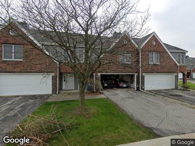
844 Kenmare Pkwy Crown Point, IN 46307
Estimated Value: $241,000 - $314,000
2
Beds
2
Baths
2,078
Sq Ft
$128/Sq Ft
Est. Value
About This Home
This home is located at 844 Kenmare Pkwy, Crown Point, IN 46307 and is currently estimated at $265,873, approximately $127 per square foot. 844 Kenmare Pkwy is a home located in Lake County with nearby schools including Timothy Ball Elementary School, Robert Taft Middle School, and Crown Point High School.
Ownership History
Date
Name
Owned For
Owner Type
Purchase Details
Closed on
Mar 22, 2007
Sold by
Balka Kelly M
Bought by
Alexander Ii Charles L
Current Estimated Value
Purchase Details
Closed on
Jun 8, 2006
Sold by
Thackerson Allen R and Thackerson Helen M
Bought by
Alexander Ii Charles L and Balka Kelly M
Home Financials for this Owner
Home Financials are based on the most recent Mortgage that was taken out on this home.
Original Mortgage
$131,500
Interest Rate
6.72%
Mortgage Type
Unknown
Create a Home Valuation Report for This Property
The Home Valuation Report is an in-depth analysis detailing your home's value as well as a comparison with similar homes in the area
Home Values in the Area
Average Home Value in this Area
Purchase History
| Date | Buyer | Sale Price | Title Company |
|---|---|---|---|
| Alexander Ii Charles L | -- | Chicago Title Insurance Co | |
| Alexander Ii Charles L | -- | Ticor Cp |
Source: Public Records
Mortgage History
| Date | Status | Borrower | Loan Amount |
|---|---|---|---|
| Open | Alexander Ii Charles L | $137,107 | |
| Previous Owner | Alexander Ii Charles L | $131,500 |
Source: Public Records
Tax History Compared to Growth
Tax History
| Year | Tax Paid | Tax Assessment Tax Assessment Total Assessment is a certain percentage of the fair market value that is determined by local assessors to be the total taxable value of land and additions on the property. | Land | Improvement |
|---|---|---|---|---|
| 2024 | $5,631 | $213,700 | $17,500 | $196,200 |
| 2023 | $2,094 | $204,900 | $17,500 | $187,400 |
| 2022 | $2,094 | $190,200 | $17,500 | $172,700 |
| 2021 | $1,788 | $168,900 | $8,700 | $160,200 |
| 2020 | $1,777 | $163,600 | $8,700 | $154,900 |
| 2019 | $1,729 | $156,700 | $8,700 | $148,000 |
| 2018 | $1,766 | $153,500 | $8,700 | $144,800 |
| 2017 | $1,574 | $140,800 | $8,700 | $132,100 |
| 2016 | $1,540 | $137,200 | $8,700 | $128,500 |
| 2014 | $1,261 | $127,700 | $8,700 | $119,000 |
| 2013 | $1,252 | $126,200 | $8,700 | $117,500 |
Source: Public Records
Map
Nearby Homes
- 2740 W 105th Ave
- 654 Harvest Ct
- 1010 Easy St Unit C
- 800 Alderbrook Ct
- 11241 Oak Ridge Ct
- 3915 W 107th Place
- 310 Pratt St
- 405 Hoffman St
- 312 Oak Cir
- 805 W North St
- 10831 Hendricks Place
- 807 N Court St
- 306 Holton Ridge
- 116 W Goldsborough St
- 7275 W 107th Ave
- 141 Vickroy Dr
- 937 Monterrey Ct Unit B
- 929 Monterrey Ct Unit C
- 10813 Lane St
- 938 Walnut Ln
- 844 Kenmare Pkwy
- 848 Kenmare Pkwy
- 840 Kenmare Pkwy
- 852 Kenmare Pkwy
- 836 Kenmare Pkwy
- 832 Kenmare Pkwy Unit 3-3
- 832 Kenmare Pkwy
- 828 Kenmare Pkwy
- 828 Kenmare Pkwy Unit 3
- 824 Kenmare Pkwy
- 843 Kenmare Pkwy
- 851 Kenmare Pkwy
- 835 Kenmare Pkwy
- 827 Kenmare Pkwy
- 810 Kenmare Pkwy
- 815 Kenmare Pkwy
- 808 Kenmare Pkwy
- 813 Kenmare Pkwy
- 804 Kenmare Pkwy
- 811 Kenmare Pkwy