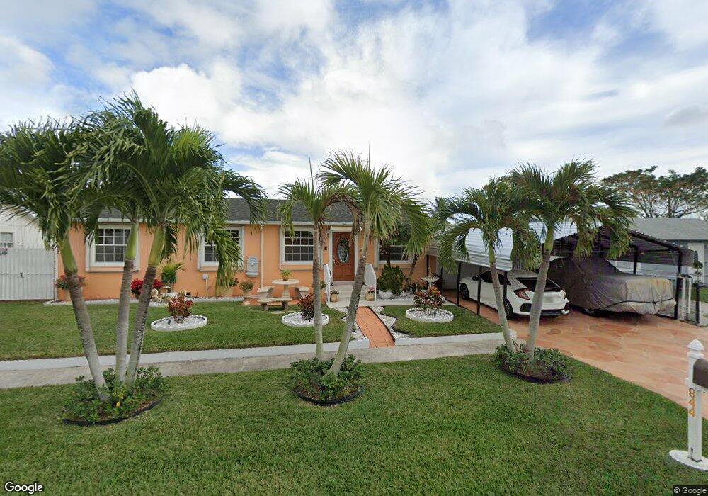
844 Scott Dr West Palm Beach, FL 33415
Cannongate NeighborhoodEstimated Value: $375,000 - $439,000
3
Beds
2
Baths
1,104
Sq Ft
$361/Sq Ft
Est. Value
About This Home
This home is located at 844 Scott Dr, West Palm Beach, FL 33415 and is currently estimated at $398,642, approximately $361 per square foot. 844 Scott Dr is a home located in Palm Beach County with nearby schools including John I. Leonard High School, Melaleuca Elementary School, and Palm Springs Middle School.
Ownership History
Date
Name
Owned For
Owner Type
Purchase Details
Closed on
Aug 27, 2004
Sold by
Alvarez Ruddy and Alvarez Elizabeth
Bought by
Ramcharran Oswald and Ramcharran Indera
Current Estimated Value
Home Financials for this Owner
Home Financials are based on the most recent Mortgage that was taken out on this home.
Original Mortgage
$162,450
Interest Rate
6.62%
Mortgage Type
Purchase Money Mortgage
Purchase Details
Closed on
Apr 13, 2001
Sold by
Cindy L Fox I
Bought by
Alvarez Ruddy and Alvarez Elizabeth
Home Financials for this Owner
Home Financials are based on the most recent Mortgage that was taken out on this home.
Original Mortgage
$91,070
Interest Rate
7.01%
Mortgage Type
FHA
Create a Home Valuation Report for This Property
The Home Valuation Report is an in-depth analysis detailing your home's value as well as a comparison with similar homes in the area
Home Values in the Area
Average Home Value in this Area
Purchase History
| Date | Buyer | Sale Price | Title Company |
|---|---|---|---|
| Ramcharran Oswald | $171,000 | Flagler Title Co | |
| Alvarez Ruddy | $92,500 | -- |
Source: Public Records
Mortgage History
| Date | Status | Borrower | Loan Amount |
|---|---|---|---|
| Previous Owner | Ramcharran Oswald | $162,450 | |
| Previous Owner | Alvarez Ruddy | $91,070 |
Source: Public Records
Tax History
| Year | Tax Paid | Tax Assessment Tax Assessment Total Assessment is a certain percentage of the fair market value that is determined by local assessors to be the total taxable value of land and additions on the property. | Land | Improvement |
|---|---|---|---|---|
| 2025 | $1,239 | $85,845 | -- | -- |
| 2024 | $1,239 | $83,426 | -- | -- |
| 2023 | $1,189 | $80,996 | $0 | $0 |
| 2022 | $1,161 | $78,637 | $0 | $0 |
| 2021 | $1,109 | $76,347 | $0 | $0 |
| 2020 | $1,085 | $75,293 | $0 | $0 |
| 2019 | $1,081 | $73,600 | $0 | $0 |
| 2018 | $1,011 | $72,228 | $0 | $0 |
| 2017 | $968 | $70,742 | $0 | $0 |
| 2016 | $972 | $69,287 | $0 | $0 |
| 2015 | $989 | $68,805 | $0 | $0 |
| 2014 | $995 | $68,259 | $0 | $0 |
Source: Public Records
Map
Nearby Homes
- 796 Hill Dr
- 821 Pipers Cay Dr
- 5076 Society Place W Unit B
- 884 Montego Dr
- 5117 Society Place W Unit C
- 1050 Summit Trail Cir Unit B
- 5130 Society Place W Unit H
- 5508 Cannon Way Unit C
- 813 Burch Dr
- 1057 Summit Trail Cir Unit B
- 1038 Summit Trail Cir Unit A
- 1139 Summit Trail Cir Unit A
- 5412 Cannon Way
- 1152 Summit Trail Cir Unit B
- 4782 Sunny Palm Cir Unit D
- 938 Sumter Rd W Unit E
- 1040 Summit Place Cir Unit B
- 5288 Bosque Ln Unit 53
- 399 Glenwood Dr
- 5053 El Claro Cir
Your Personal Tour Guide
Ask me questions while you tour the home.