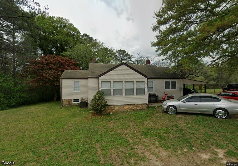
8449 Dorris Rd Douglasville, GA 30134
Estimated Value: $200,000 - $265,205
2
Beds
2
Baths
1,088
Sq Ft
$215/Sq Ft
Est. Value
About This Home
This home is located at 8449 Dorris Rd, Douglasville, GA 30134 and is currently estimated at $234,051, approximately $215 per square foot. 8449 Dorris Rd is a home located in Douglas County with nearby schools including Burnett Elementary School, Chestnut Log Middle School, and Douglas County High School.
Ownership History
Date
Name
Owned For
Owner Type
Purchase Details
Closed on
Mar 2, 2016
Sold by
Parson Jack L
Bought by
Mvp Property Holdings Llc
Current Estimated Value
Home Financials for this Owner
Home Financials are based on the most recent Mortgage that was taken out on this home.
Original Mortgage
$30,000
Outstanding Balance
$23,800
Interest Rate
3.72%
Mortgage Type
New Conventional
Estimated Equity
$210,251
Create a Home Valuation Report for This Property
The Home Valuation Report is an in-depth analysis detailing your home's value as well as a comparison with similar homes in the area
Home Values in the Area
Average Home Value in this Area
Purchase History
| Date | Buyer | Sale Price | Title Company |
|---|---|---|---|
| Mvp Property Holdings Llc | $60,000 | -- |
Source: Public Records
Mortgage History
| Date | Status | Borrower | Loan Amount |
|---|---|---|---|
| Open | Mvp Property Holdings Llc | $30,000 |
Source: Public Records
Tax History Compared to Growth
Tax History
| Year | Tax Paid | Tax Assessment Tax Assessment Total Assessment is a certain percentage of the fair market value that is determined by local assessors to be the total taxable value of land and additions on the property. | Land | Improvement |
|---|---|---|---|---|
| 2024 | $3,549 | $85,400 | $59,840 | $25,560 |
| 2023 | $3,549 | $80,760 | $56,320 | $24,440 |
| 2022 | $2,414 | $59,520 | $35,200 | $24,320 |
| 2021 | $2,176 | $53,440 | $35,200 | $18,240 |
| 2020 | $2,217 | $53,440 | $35,200 | $18,240 |
| 2019 | $2,084 | $53,040 | $35,200 | $17,840 |
| 2018 | $2,068 | $52,280 | $35,200 | $17,080 |
| 2017 | $959 | $48,280 | $33,760 | $14,520 |
| 2016 | $665 | $44,520 | $30,720 | $13,800 |
| 2015 | $702 | $44,560 | $31,040 | $13,520 |
| 2014 | $624 | $41,928 | $30,080 | $11,848 |
| 2013 | -- | $44,588 | $32,000 | $12,588 |
Source: Public Records
Map
Nearby Homes
- 6253 Hospital Way
- 8541 Westchester Dr
- 8538 Westchester Dr
- 6419 Katherine St
- 8523 Duncan St
- 6214 Hagin St
- 8546 Adair St
- 8676 Ashley Way
- 8693 Ashley Way
- 8692 Ashley Way
- 8694 Ashley Way
- 6235 Cornelia Dr
- 8738 Campbellton St
- 8612 Campbellton St
- 6339 Cornelia Dr
- 6210 Douglas Manor Ct
- 5823 Fairburn Rd
- 6648 Ridge Ave
- 6441 Rose Cir
- 8090 Colquitt St
- 8469 Dorris Rd
- 8466 Estelle St
- 8482 Estelle St
- 6304 Fairburn Rd
- 6304 Highway 92
- 8498 Estelle St
- 8453 Estelle St
- 8463 Estelle St
- 8501 Westchester Dr
- 6273 Melrose St
- 8475 Estelle St
- 6250 Hospital Way
- 8503 Westchester Dr
- 6291 Melrose St
- 6242 Hospital Way
- 8505 Westchester Dr
- 6305 Melrose St
- 8495 Estelle St
- 8507 Westchester Dr
- 8509 Westchester Dr