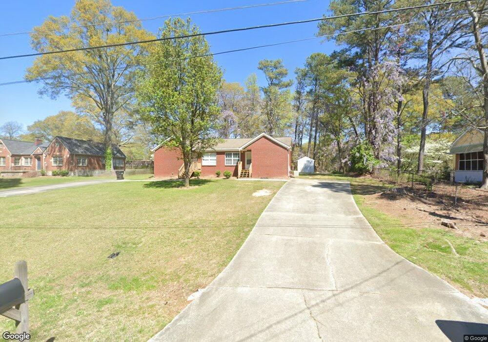
8486 Duncan St Douglasville, GA 30134
Estimated Value: $239,000 - $331,997
4
Beds
4
Baths
2,090
Sq Ft
$134/Sq Ft
Est. Value
About This Home
This home is located at 8486 Duncan St, Douglasville, GA 30134 and is currently estimated at $280,749, approximately $134 per square foot. 8486 Duncan St is a home located in Douglas County with nearby schools including Burnett Elementary School, Chestnut Log Middle School, and Douglas County High School.
Ownership History
Date
Name
Owned For
Owner Type
Purchase Details
Closed on
Jun 26, 2018
Sold by
Dempsey David
Bought by
Polston Willie A and Polston Rebecca E
Current Estimated Value
Purchase Details
Closed on
Jan 27, 2011
Sold by
Taylor Steven K
Bought by
Dempsey David
Home Financials for this Owner
Home Financials are based on the most recent Mortgage that was taken out on this home.
Original Mortgage
$97,000
Interest Rate
4.82%
Mortgage Type
New Conventional
Create a Home Valuation Report for This Property
The Home Valuation Report is an in-depth analysis detailing your home's value as well as a comparison with similar homes in the area
Home Values in the Area
Average Home Value in this Area
Purchase History
| Date | Buyer | Sale Price | Title Company |
|---|---|---|---|
| Polston Willie A | $100,000 | -- | |
| Dempsey David | $97,000 | -- |
Source: Public Records
Mortgage History
| Date | Status | Borrower | Loan Amount |
|---|---|---|---|
| Previous Owner | Dempsey David | $97,000 |
Source: Public Records
Tax History Compared to Growth
Tax History
| Year | Tax Paid | Tax Assessment Tax Assessment Total Assessment is a certain percentage of the fair market value that is determined by local assessors to be the total taxable value of land and additions on the property. | Land | Improvement |
|---|---|---|---|---|
| 2024 | $4,462 | $107,360 | $27,200 | $80,160 |
| 2023 | $4,462 | $102,120 | $25,600 | $76,520 |
| 2022 | $3,417 | $84,240 | $16,000 | $68,240 |
| 2021 | $2,873 | $70,560 | $16,000 | $54,560 |
| 2020 | $2,928 | $70,560 | $16,000 | $54,560 |
| 2019 | $1,572 | $69,120 | $16,000 | $53,120 |
| 2018 | $2,622 | $66,280 | $16,000 | $50,280 |
| 2017 | $2,295 | $57,400 | $15,360 | $42,040 |
| 2016 | $2,276 | $55,920 | $15,360 | $40,560 |
| 2015 | $2,091 | $55,120 | $15,520 | $39,600 |
| 2014 | $2,091 | $50,920 | $15,040 | $35,880 |
| 2013 | -- | $53,880 | $16,000 | $37,880 |
Source: Public Records
Map
Nearby Homes
- 8523 Duncan St
- 6419 Katherine St
- 8546 Adair St
- 8693 Ashley Way
- 8676 Ashley Way
- 8612 Campbellton St
- 8692 Ashley Way
- 8694 Ashley Way
- 6253 Hospital Way
- 6648 Ridge Ave
- 8738 Campbellton St
- 8541 Westchester Dr
- 8538 Westchester Dr
- 6787 W Strickland St
- 6214 Hagin St
- 6339 Cornelia Dr
- 6235 Cornelia Dr
- 8090 Colquitt St
- 8478 Duncan St
- 8494 Duncan St
- 6460 Katherine St
- 0 Duncan St Unit 7554546
- 0 Duncan St Unit 7460868
- 0 Duncan St Unit 7460855
- 0 Duncan St Unit 7359019
- 0 Duncan St Unit 8398964
- 0 Duncan St Unit 8389998
- 0 Duncan St
- 8500 Duncan St
- 6549 Katherine St
- 8491 Duncan St
- 8497 Duncan St
- 8465 Lynn Ave
- 8506 Duncan St
- 8479 Duncan St
- 8485 Lynn Ave
- 6444 Katherine St
- 8505 Duncan St