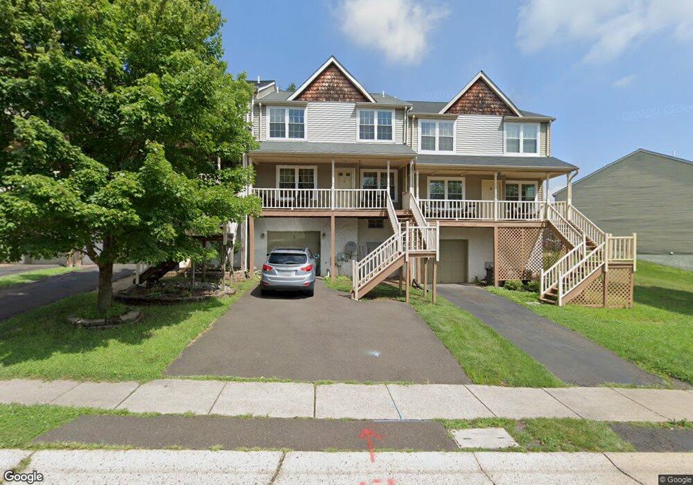
85 Mulberry Dr Southampton, PA 18966
Estimated Value: $413,000 - $498,000
4
Beds
3
Baths
1,904
Sq Ft
$246/Sq Ft
Est. Value
About This Home
This home is located at 85 Mulberry Dr, Southampton, PA 18966 and is currently estimated at $468,098, approximately $245 per square foot. 85 Mulberry Dr is a home located in Bucks County with nearby schools including Rolling Hills Elementary School, Richboro Middle School, and Council Rock High School - South.
Ownership History
Date
Name
Owned For
Owner Type
Purchase Details
Closed on
Feb 1, 2017
Sold by
Shurafa Manal
Bought by
Shurafa Manal and Al Qasem Osama A
Current Estimated Value
Home Financials for this Owner
Home Financials are based on the most recent Mortgage that was taken out on this home.
Original Mortgage
$120,000
Outstanding Balance
$99,632
Interest Rate
4.3%
Mortgage Type
New Conventional
Estimated Equity
$368,466
Purchase Details
Closed on
Nov 30, 1995
Sold by
Alban Sherry Ann and Kaplan Scott E
Bought by
Al Oasem Osama and Al Oasem Manal S
Create a Home Valuation Report for This Property
The Home Valuation Report is an in-depth analysis detailing your home's value as well as a comparison with similar homes in the area
Home Values in the Area
Average Home Value in this Area
Purchase History
| Date | Buyer | Sale Price | Title Company |
|---|---|---|---|
| Shurafa Manal | -- | None Available | |
| Al Oasem Osama | $126,000 | -- |
Source: Public Records
Mortgage History
| Date | Status | Borrower | Loan Amount |
|---|---|---|---|
| Open | Shurafa Manal | $120,000 |
Source: Public Records
Tax History Compared to Growth
Tax History
| Year | Tax Paid | Tax Assessment Tax Assessment Total Assessment is a certain percentage of the fair market value that is determined by local assessors to be the total taxable value of land and additions on the property. | Land | Improvement |
|---|---|---|---|---|
| 2025 | $5,640 | $29,280 | $3,520 | $25,760 |
| 2024 | $5,640 | $29,280 | $3,520 | $25,760 |
| 2023 | $5,315 | $29,280 | $3,520 | $25,760 |
| 2022 | $5,267 | $29,280 | $3,520 | $25,760 |
| 2021 | $5,100 | $29,280 | $3,520 | $25,760 |
| 2020 | $4,985 | $29,280 | $3,520 | $25,760 |
| 2019 | $3,498 | $29,280 | $3,520 | $25,760 |
| 2018 | $4,687 | $29,280 | $3,520 | $25,760 |
| 2017 | $4,506 | $29,280 | $3,520 | $25,760 |
| 2016 | $4,506 | $29,280 | $3,520 | $25,760 |
| 2015 | -- | $29,280 | $3,520 | $25,760 |
| 2014 | -- | $29,280 | $3,520 | $25,760 |
Source: Public Records
Map
Nearby Homes
- 2010 Barry Ct Unit 743B
- 105 Hopkins Ct Unit 744A
- 23 Brianna Rd
- 151 Knox Ct
- 6 Springwood Place
- 80 Hershey Ct
- 19 Seton Hill Ct
- 163 Leedom Way Unit 25
- 14 Chesapeake Dr
- 102 Keenan Ln
- 21019 Bennett Place Unit 7
- 2604 Beacon Hill Dr Unit 2
- 7 Bennett Place
- 281 E Village Rd
- 104 Cornell Rd
- 31 Hillcroft Way
- 9017 Heritage Place Unit 9
- 60 Signal Hill Rd
- 1011 Diamond Dr Unit 1011
- 15 Dover Place