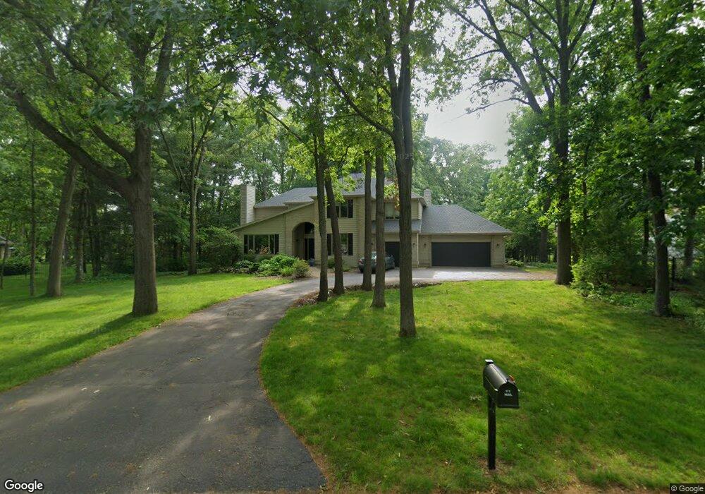
8510 Finch Dr Kalamazoo, MI 49009
Estimated Value: $556,830 - $633,000
4
Beds
5
Baths
3,570
Sq Ft
$170/Sq Ft
Est. Value
About This Home
This home is located at 8510 Finch Dr, Kalamazoo, MI 49009 and is currently estimated at $607,458, approximately $170 per square foot. 8510 Finch Dr is a home located in Kalamazoo County with nearby schools including Amberly Elementary School, Portage West Middle School, and Portage Central High School.
Ownership History
Date
Name
Owned For
Owner Type
Purchase Details
Closed on
Jun 26, 2008
Sold by
Shaull Charles D and Shaull Kathleen
Bought by
Frey Robert C and Frey Athanacia L
Current Estimated Value
Create a Home Valuation Report for This Property
The Home Valuation Report is an in-depth analysis detailing your home's value as well as a comparison with similar homes in the area
Home Values in the Area
Average Home Value in this Area
Purchase History
| Date | Buyer | Sale Price | Title Company |
|---|---|---|---|
| Frey Robert C | $342,000 | Ppr Title |
Source: Public Records
Tax History Compared to Growth
Tax History
| Year | Tax Paid | Tax Assessment Tax Assessment Total Assessment is a certain percentage of the fair market value that is determined by local assessors to be the total taxable value of land and additions on the property. | Land | Improvement |
|---|---|---|---|---|
| 2025 | $7,274 | $246,100 | $0 | $0 |
| 2024 | $2,142 | $229,600 | $0 | $0 |
| 2023 | $2,042 | $206,200 | $0 | $0 |
| 2022 | $6,603 | $190,100 | $0 | $0 |
| 2021 | $6,414 | $187,000 | $0 | $0 |
| 2020 | $6,262 | $183,700 | $0 | $0 |
| 2019 | $5,753 | $178,000 | $0 | $0 |
| 2018 | $3,575 | $169,300 | $0 | $0 |
| 2017 | -- | $169,500 | $0 | $0 |
| 2016 | -- | $169,900 | $0 | $0 |
| 2015 | -- | $161,100 | $22,500 | $138,600 |
| 2014 | -- | $161,100 | $0 | $0 |
Source: Public Records
Map
Nearby Homes
- 5727 Bob White Ave
- 5353 Chickadee Dr
- 5284 Green Pine Ln
- 5420 Whippoorwill Dr
- 8420 S 12th St
- 5191 W R Ave
- 5151 W R Ave
- 5660 Saddle Club Dr
- 7873 Shepherds Glen Ct
- 5825 Saddle Club Dr
- 8022 Magistrate St
- 6139 Delasala Ct
- 5456 Stoney Brook Rd
- 7839 Clydesdale Ave Unit 93
- 7620 Stablebrook Cir
- 6737 W Q Ave
- 4186 Vanderbilt Ave
- 4788 Norfolk Cir
- 7440 Brindle Trail Unit 194
- 6061 Equestrian Woods Ct
- 5655 Swallow Ave
- 5650 Blue Spruce Ln
- 5677 Swallow Ave
- 8551 Old Stone Cir
- 5695 Swallow Ave
- 5611 Swallow Ave
- 8535 Old Stone Cir
- 8511 Finch Dr
- 5610 Blue Spruce Ln
- 5707 Swallow Ave
- 5660 Swallow Ave
- 5680 Swallow Ave
- 5595 Swallow Ave
- 5700 Swallow Ave
- 5645 Blue Spruce Ln
- 8548 Old Stone Cir
- 5610 Swallow Ave
- 5615 Blue Spruce Ln
- 5710 Swallow Ave
- 8548 Old Oak Cir